Maps of Baden-Württemberg

Nigra Sylva XI. Nova Tabula. [Karte], in: Claud. Ptolemaeus. Geographia lat. cum mappis [...], S. 374.
1 Karte aus Atlas Münster, Sebastian [und Ptolemaeus, Claudius]
Die Landgrafschaft Nellenburg die Landvogtey Altorf
1 Karte : Kupferdruck ; 19 x 27 cm Reilly F. J. J. von Reilly
Circuli Sveviae
1 : 477000 Švábsko (Německo) Hase, Johann Matthias Homan[n]ianorum Heredum
<<[Die>> Gaugrafschaften im 11. Jahrhundert]
1 : 800000 1 Karte Wurster, Winterthur
Charte vom Churfürstenthum Schwaben
1 Karte : Kupferdruck ; 32 x 38 cm Kauffer bey A. G. Schneider u: Weigel
Charte von Schwaben
1 Karte : Radierung ; 47 x 60 cm Amman s.n.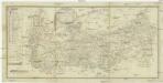
Commercial Charte
1 : 290000 Horní Rakousko (Rakousko) Eberle Walz
Circvli Sveviae Mappa
Hase, Johann Matthias Homann
Charte von dem Königreiche Wirtemberg, dem Grossherzogthume Baden und den königl. bayerschen Acquisitionen in Schwaben [et]c., oder der Ober=Rhein
1 Karte : Kupferdruck ; 44 x 49 cm im Verlage des Geograph. Instituts
Charte von Schwaben
1 : 390000 Švábsko (Německo) Amman, Ignaz Ambros von
Charte von dem Königreiche Wirtemberg und dem gros Herzogthume Baaden
1 : 800000 Bádensko (Německo)
CHARTE von dem KÖNIGREICHE WIRTEMBERG und dem GROSHERZOGTHUME BAADEN
1 : 800000 Bádensko (Německo)
Charte von Schwaben
1 Karte : Kupferdruck ; 44 x 50 cm im Verlage des Geograph. Instituts
Circvli Sveviae Mappa
1 : 470000 Mollova mapová sbírka Hase, Johann Matthias Homann, Johann Baptista - dědici
Swabia.
1 : 530000 Cary, John, ca. 1754-1835
Cercle De Souabe, dans lequel sont distingués les principaux Etats, et les Enclaves De La Maison D'Autriche
Robert de Vaugondy, Didier Remondini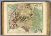
Swabia.
1 : 570000 Lizars, Daniel
Der schwæbische Kreis. nebst den österreichischen Besizungen in Schwaben
1 Karte : Kupferdruck ; 46 x 51 cm im Verlage des Industrie-Comptoirs
Circulus Suevicus complectens omnes status subdivisos ex quibus constat. edenta
1 : 555000 Bádensko-Württembersko (Německo) Valk, Gerhard G. Valk
Reise-Karte von Schwaben mit angezeigten Chausseen und Strassen
1 : 870000 Švábsko (Německo) Amman, Ignaz Ambros von Staedelen, M. L. Stettinischen Buchhandlung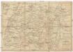
Reise-Karte von Schwaben mit angezeigten Chausseen und Strassen
1 : 800000 Švábsko (Německo) Amman, Ignaz Ambros von Staedelen, M. L. im Verlag der Stettinischen Buchhandlung
Teutzchlandes Schwaebischer Creiss samt dazugehörigen Provintzen
1 : 1900000 Mollova mapová sbírka Weigel, Christoph Weigel, Christoph I.
Deß Hayligen Römischen Reichs Schwebischen Kraysssampt seinen Vmb unnd Inligenden lannd vnnd Herrschafften
1 : 790000 Mollova mapová sbírka Mannasser, Daniel Mittnacht, Moritz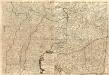
Le Theatre de la Guerre Sur le Haut Rhein Contenant l'Alsace
1 : 480000 Mollova mapová sbírka Nolin, Jean-Baptiste Rousseau, L. B. Leonard, Jean
Circvlvs Svevicvs
1 : 780000 Mollova mapová sbírka Weigel, Christoph Kauffer, Michael Weigel, Christoph I.
[Charte vom Königreich Würtemberg, und dem Grossherzogthum Baden]
Neuester Schul-Atlas Walch, Johann im Verlag bei Joh. Walch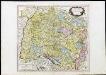
Cercle De Souabe dans lequel sont distingués les principaux Etats, et les Enclaves De La Maison D'Autriche
Robert de Vaugondy, Didier Remondini
Circulus Suevicus Complectens Omnes Status Subdivisos ex quibus constat
1 : 560000 Mollova mapová sbírka Valk, Gerhard Valck, Gerard
Theatrum Belli ad Rhenum Superior. nec non Munimentorum tum Imperialium, tum Gallicorum ichnographica exhibitio accurate tradita
1 : 375000 Mollova mapová sbírka Homann, Johann Baptist Homann, Johann Baptista - dědici
![Nigra Sylva XI. Nova Tabula. [Karte], in: Claud. Ptolemaeus. Geographia lat. cum mappis [...], S. 374.](https://images-0.georeferencer.com/images/iiif/393628289934/full/,300/0/native.jpg)

