Maps of Δήμος Μονεμβασιάς

Cerigo Insul. [Karte], in: Gerardi Mercatoris Atlas, sive, Cosmographicae meditationes de fabrica mundi et fabricati figura, S. 523.
1 Karte aus Atlas Mercator, Gerhard Montanus, Petrus
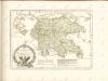
Archipelagi Insularum Aliquot Descrip., [Cerigo] [Karte], in: Theatrum orbis terrarum, S. 246.
1 Karte aus Atlas Ortelius, Abraham
Archipelagi Insularum Aliquot Descrip., [Cerigo] [Karte], in: Theatrum orbis terrarum, S. 341.
1 Karte aus Atlas Ortelius, Abraham Vrients, Jan Baptista
Porto St. Nicolo in I. Serigo
Greece Gerard van Keulen
Porto Serigo
Greece Gerard van Keulen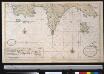
De zuijdelijkste zeekusten van Morea geleegen in de Middellandsche Zee
Greece Gerard van Keulen

Carte de la Morée anciennement Peloponnèse, 1785
Carte de la Morée anciennement Peloponnèse, 1785. Gravé par L.A. Dupuis ... Lieues communes de France, 20[ = 128 mm] [Paris]
[General-Karte der Europaeischen Türkei und des Königreiches Griechenland]
1 : 864000 osmanská říše Scheda, Joseph von Artaria & Comp.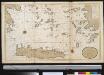
Het zuijderdeel van de Archipel Lagusche Eijlanden int groodt
Greece Gerard van Keulen
The Ionian Islands and Malta.
1 : 410000 Arrowsmith, John
Griechenland.
1 : 1600000 Meyer, Joseph, 1796-1856
Ancient Greece : southern part
1 : 1500000 published under the superintendence of the Society for the Diffusion of Useful Knowledge engraved by J. & C. Walker London : Baldwin and Cradock
Turkey III : containing the southern part of Greece and Candia
published under the superintendence of the Society for the Diffusion of Useful Knowledge engraved by J. & C. Walker London : Baldwin and Cradock
Greece.
1 : 1480000 Mitchell, Samuel Augustus
Graecia
Schul-Atlas der alten Welt bei Justus Perthes
Neueste Karte von Griechenland
Grosser Hand-Atlas über alle Theile der Erde in 170 Karten Meyer, J. Verlag des Bibliographischen Instituts
Carte De La Mer Mediterranee. XI.
Roux, Joseph
Greece and the Ionian Republic.
1 : 2000000 Colton, G.W.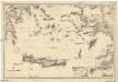
Mittelmeer
1 : 600000 Egejské moře Reichs-Marine-Amt
Turkey
1 : 6170000 Kréta (Řecko) Walker, C. Baldwin & Cradock
Turkey in Europe, N. Greece.
1 : 1457280 Letts, Son & Co.
Greece And The Ionian Republic.
1 : 1584000 Colton, G.W.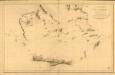
Carte réduite de la partie Méridionale de l’Archipel
Carte réduite de la partie Méridionale de l'Archipel, rédigée d'après les travaux exécutées dans les années 1818 & 1819 par M. Gauttier. [Paris] : Dépôt Général de la Marine
[Die Balkan-Halbinsel, Blatt 3]
Adolf Stieler's Handatlas über alle Theile der Erde und über das Weltgebäude Stieler, Adolf Justus Perthes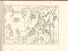

Griechenland und die Jonischen Inseln
Schul-Atlas in 36 Karten Völter, Daniel Verlag der J.M. Dannheimer'schen Buchhandlung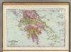
Greece.
1 : 1470000 Rand McNally and Company
GRAECIAE ANTIQUAE DESIGNATIO NOVA
Řecko Lotter, Tobias Conrad impensis T. Conr. Lotteri
![Cerigo Insul. [Karte], in: Gerardi Mercatoris Atlas, sive, Cosmographicae meditationes de fabrica mundi et fabricati figura, S. 523.](https://images-0.georeferencer.com/images/iiif/137849552206/full/,300/0/native.jpg)

