Maps of Lombardia

Brescia Episcopatus Mediolanum Ducatus [Karte], in: Gerardi Mercatoris Atlas, sive, Cosmographicae meditationes de fabrica mundi et fabricati figura, S. 444.
1 Karte aus Atlas Mercator, Gerhard Montanus, Petrus
Lombardia
1 : 250000 Lombardie (Itálie) Arrigoni, Ferdinando Artaria, Ferdinando Ferdinando Arrigoni
Jeziger Kriegs-Plan in Italien
1 : 525000 Mollova mapová sbírka
Strassen-Karte des Lombardisch-Venezianischen Koenigreiches
1 : 432000 Lombardie (Itálie)

Status Mediolanensis
1 : 460000 Mollova mapová sbírka Wolf, Jeremias Bodenehr, Gabriel
Carta geografica-postale delle province Lombarde
1 : 500000 Lombardie (Itálie)
Karte der Lombardie.mit der Eintheilung in Berg= Hügel= und Tief= Land
mapa VKOL Doležal, A. Lith. Anst. v. F. Köke
Belli typvs in Itallia, victricis aquilae progreßus in statv Mediolanensi et dvcatv Mantvae demonstrants
1 : 530000 Itálie severní Homann, Johann Baptist Io. Bapt. Homannum
Belli typvs in Itallia, victricis Aquilae progreßus in statv Mediolanensi et dvcatv Mantvae demonstrans
1 : 540000 Itálie severní Homann, Johann Baptist per Io. Bapt. Homannvm
L'Etat de Milan
1 : 440000 Mollova mapová sbírka Nolin, Jean-Baptiste Nolin, Jean Baptiste

Status Mediolanensis in principales suas parties divisas, quarum aliquae Venetorum aliae ducatorum Mantuae Parmae et Modena
1 : 462500 Mantova (Itálie) Lotter, Tobias Conrad Bodenehr, Georg Conrad Tob. Conr. Lotter
Status Mediolanensis in principales suas parties divisas, quarum aliquae Venetorum aliae ducatorum Mantuae Parmae et Modena
1 : 462500 Mantova (Itálie) Lotter, Tobias Conrad Bodenehr, Georg Conrad Tob. Conr. Lotter
Status Mediolanensis in principales suas partes divisas, quarum aliquae Venetorum aliae ducatorum Mantuae, Parmae et Modena
1 : 460000 Mantova (Itálie) Lotter, Tobias Conrad Bodenehr, Georg Conrad Tob. Conr. Lotter
Ducatus Mediolanensis
1 : 530000 Mollova mapová sbírka Seutter, Matthäus Seutter, Matthäus
L'Etat de Milan divisé en ses Principales Parties avec Partie des Etats de Venise et des Duchés de Mantoue, de Parme, et Modene &c.
1 : 440000 Mollova mapová sbírka Nolin, Jean-Baptiste Nolin, Jean Baptiste

Mailändische Feldzug
Mollova mapová sbírka Riegel, Christoph Riegel, Christoph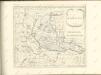

Ducatus Mediolanensis Parmensis et Montisferrati cum omnibus suis provinciis novissima descriptio
1 : 520000 Milán-oblast (Itálie) Danckerts, Justus per Iustinum Danckerts
Special Charte des Herzogthums Mayland
1 : 536000 Lombardie (Itálie) Riegel, Christoph Christoph Riegel
Ducatus Mediolanensis Parmensis et Montisferrati
1 : 500000 Mollova mapová sbírka Danckerts, Justus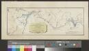
Carte de la nouvelle route depuis le Tyrol par le Col de Stilfs jusqu'a Milan
1 : 89500 1 Karte Hch Keller del ; Grimminger lith. Meyer, Zürich
Ducatus Mediolanensis Parmensis et Montisferrati cum omnibus suis provinciis novissima descriptio
1 : 500000 1 Karte : Kupferdruck ; 46 x 56 cm Danckerts, Justus [Danckerts]
Carte géologique de la Suisse
1 : 380000 1 Karte auf 4 Bl. par B. Studer et A. Escher de la Linth d'après leurs propres observations et les communications de leurs amis propriété de l'Etablissement topographique de J. Wurster & Comp., Winterthur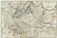
Les Estats Du Duché De Milan
1 : 840000 Mollova mapová sbírka Fer, Nicolas de Loon, Herman van Fer, Nicolas de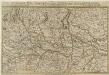
Theatrum Belli Italici. Anni 1701. Seu Novissima Tabula Geographica
1 : 530000 Mollova mapová sbírka Pauli, Georg Adam Joseph Engelbrecht, Christian
Neue Schweizerkarte von 1847
1 : 300000 1 Karte auf 4 Bl. als Wand- und Reliefkarte topisch und politisch dargestellt von Eduard Winckelmann Tobias Dannheimer, Kempten
![Brescia Episcopatus Mediolanum Ducatus [Karte], in: Gerardi Mercatoris Atlas, sive, Cosmographicae meditationes de fabrica mundi et fabricati figura, S. 444.](https://images-2.georeferencer.com/images/iiif/360980926680/full/,300/0/native.jpg)

