Maps of Regierungsbezirk Düsseldorf

Gueldre Espagnole, ou Quartier De Ruremonde Dans Le Duché De Gueldre. Avec ses Englanes dans les Pays circomvoisins. [Karte], in: Atlas nouveau, contenant toutes les parties du monde [...], Bd. 2, S. 45.
1 Karte aus Atlas Sanson, Nicolas Jaillot, Alexis Hubert und Mortier, Pieter
Gueldre Espagnole, ou Quartier de Ruremonde dans le duché de Gueldre avec ses enclaves dans les pays circomvoisins
1 : 200000 dressé sur les memoires les plus nouveaux par le S.r Sanson, geographe ordinaire du Roy. A Paris : chez H. Jaillot, joignant les grands Augustins, aux deux globes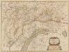
Ducatus Gelriae pars secunda Quae est Ruremondensis. [Karte], in: Novus atlas absolutissimus, Bd. 3, S. 88.
1 Karte aus Atlas Janssonius Offizin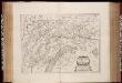
Ducatus Gelriae pars secunda quae est Ruremondensis / [Joannes Janssonius]
1 : 300000 Annotatie: Het eerst verschenen in: Des nieuwen Atlantis aenhang ... derde deel ... - Amstelodami : apud Ioannem Ianssonium, 1644; Origineel is Blad 67 in atlas factice; Annotatie geografische gegevens: Zuidoost boven Janssonius, Joannes (jr.) (1588-1664) [Amsterdam : Joannes Janssonius]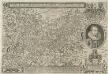
Ivliae et Cliviae Dvcatvvm descriptio Avctior nvnc et emendatior Vrbivm, Oppidorvm Pagorvm, qvibvs abvndant, veram distantiam de Monstrans
1 : 200000 Mollova mapová sbírka Quad, Matthias Bussemacher, Johann
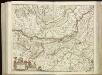
Gueldre Espagnole, ou Quartier de Ruremonde dans le Duché de Gueldre
1 : 210000 Mollova mapová sbírka Sanson, Guillaume Jaillot, Alexis Hubert
Ducatus Geldria et Zutphania Comitatus
Mollova mapová sbírka Danckerts, Justus
Ruermond het over vierdeel van Gelderlandt
1 : 250000 [Nicolaas van Geelkercken] [S.l.] : [s.n.]
Ducatus Geldriae nec non Comitatus Zutphaniae cum adjecentibus Regionibus denuo recogniti, et editi a
Mollova mapová sbírka Visscher, Nicolaes
[98][99] Tetrachia Ducatus Geldriae Ruremondana sive Hispanica, uit: Atlas sive Descriptio terrarum orbis
Annotatie: Gedigitaliseerde versie. Amsterdam. Heiloo : Picturae (vervaardiger), 2015. tiff-bestand. Gedigitaliseerd: 07-01-2015; Origineel: Universiteitsbibliotheek Vrije Universiteit (XL.05127.-) ; Netherlands; Titelpagina ontbreekt Wit, Frederik de Amsterdam : Frederick de Wit
Limburg, uit: Sterfte-atlas van Nederland over 1860-1874 / [uitgave van de Nederlandsche Maatschappij tot Bevordering der Geneeskunst]
titelvariant: Sterfte-atlas van Nederland; Annotatie: Alleen kaartbijlage aanwezig Pieter Harmen Witkamp 1816-1892; Nederlandsche Maatschappij tot Bevordering der Geneeskunst Amsterdam : van Rossen
[Kaart], uit: Sleeswijk's kaart van Limburg : naar officieële gegevens bewerkt voor wandelaars, wielrijders en automobilisten, voor school, kantoor en huiskamer : met nauwkeurige afstandsbepalingen in kilometers tusschen de plaatsen
1 : 150000 titelvariant: Limburg; Annotatie: Omslagtitel; Tweede titel boven de kaart: Limburg; In verso: plaatsnamenregister; Annotatie geografische gegevens: Schaalstok; Legenda J.A. Sleeswijk, Bussum; J. Smulders & Co., 's-Gravenhage Bussum : J.A. Sleeswijk / (Lith. J. Smulders & Co., Den Haag)
Clivia Dvcatvs et Ravestein Dominivm
1 : 230000 Mollova mapová sbírka Schenk, Pieter Schenk, Peter I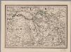
[15], uit: Hydro-Oro und Chorographische General Karte des Koenigreichs der Niederlande und der angrenzenden Länder bis Paris : mit der Angabe der Kunst und Heer-Strassen und der Entfernung der Poststationen / ... zusammengetragen und reducirt von ... Wilhelm Müller
1 : 400000 titelvariant: Generalkarte des Koenigreichs Hannover; Annotatie: 1e supplement bij: Generalkarte des Koenigreichs Hannover (1818) Müller, Wilhelm (fl. 1818) [Hannover : Wilhelm Müller]
Clivia Ducatus Et Ravestein Dominium. [Karte], in: Le théâtre du monde, ou, Nouvel atlas contenant les chartes et descriptions de tous les païs de la terre, Bd. 1, S. 314.
1 Karte aus Atlas Blaeu, Willem Janszoon und Blaeu, Joan Blaeu, Willem Janszoon
Le Duché De Cleves; La Seigneurie De Ravenstein, Et Le Comté De Meurs. [Karte], in: Atlas nouveau, contenant toutes les parties du monde [...], Bd. 1, S. 214.
1 Karte aus Atlas Sanson, Nicolas Jaillot, Alexis Hubert und Mortier, Pieter
Brabantiae pars orientalis continens territoria Oosteruici, Maselandiae, Campiniae, Peelandiae, Rauesteini, Kuyckianae, comitatus Hornanum et Meganum locumq[ue] illum paludosum de Peel nuncupatum
1 : 330000 Brabantsko Hondius, Henricus sumptibus Henricii Hondii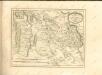

TETRARCHIA | Ducatus Gelriæ | RVRÆMVNDENSIS
[Amsterdam : Joan Blaeu]
Clivia Ducatus Et Ravestein Dominium. [Karte], in: Theatrum orbis terrarum, sive, Atlas novus, Bd. 1, S. 224.
1 Karte aus Atlas Blaeu, Joan Blaeu, Willem Janszoon
Clivia Ducatus Et Ravestein Dominium. [Karte], in: Novus atlas absolutissimus, Bd. 2, S. 130.
1 Karte aus Atlas Janssonius Offizin
Clivia Ducatus Et Ravestein Dominium. [Karte], in: Novus Atlas, das ist, Weltbeschreibung, Bd. 1, S. 285.
1 Karte aus Atlas Blaeu, Joan Blaeu, Willem Janszoon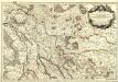
Les Duchés, de Cleves, de Iuliers et de Limbourg, le Comté de Meurs, le Quartier de Ruremonde dans le Duché de Gueldres, L'Archevesché et Eslectorat de Cologne &c.
1 : 200000 Mollova mapová sbírka Jaillot, Alexis-Hubert Jaillot, Alexis Hubert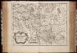
Le duché de Clèves, la seigneurie de Ravenstein, et le comté de Meurs / tirée des mémoirs les plus recents par le Sr. Sanson
1 : 200000 Annotatie: Origineel is Blad 65 in atlas factice Guillaume Sanson 1633-1703 A Paris : chez H. Iaillot
Bijlage 4, uit: Eindverslag over de onderzoekingen en uitkomsten van den Dienst der Rijksopsporing van Delfstoffen in Nederland, 1903-1916
Annotatie: Met lit. opg Departement van Landbouw, Nijverheid en Handel. Dienst der Rijksopsporing van Delfstoffen ['s-Gravenhage : Martinus Nijhoff]
23me Helmont, uit: [Nouvelle carte de la Hollande, d'après Kraijenhoff et les meilleures cartes connus] / [Ph. Vandermaelen]
1 : 130000 Annotatie: Ontbreekt: bl. 1-12 Vandermaelen, Philippe Marie Guillaume Bruxelles : Établissement Géographique
CLIVIA | DVCATVS | ET | RAVESTEIN | DOMINIVM
[Amsterdam : Joan Blaeu]
23. Peel, uit: Geologische kaart van Nederland / door W.C.H. Staring ; bew. aan de Topographische Inrichting
1 : 200000 Winand Carel Hugo Staring 1808-1877; Topographische Inrichting, 's-Gravenhage 's-Gravenhage : Belinfante
![Gueldre Espagnole, ou Quartier De Ruremonde Dans Le Duché De Gueldre. Avec ses Englanes dans les Pays circomvoisins. [Karte], in: Atlas nouveau, contenant toutes les parties du monde [...], Bd. 2, S. 45.](https://images-2.georeferencer.com/images/iiif/955547911252/full/,300/0/native.jpg)

