Maps of Alsace

[Exactissima Helvetiae, Rhaetiae, Valesiae ... tabula]
1 : 850000 9 Karten [Kopie von Adrian Braakman] [chez Pierre Schenk et Adrian Braakman], [Amsterdam]
Sect. 25: Mülhausen i/E, uit: Geologische Karte des Deutschen Reichs in 27 Blaettern / [von] Richard Lepsius ; Red. von C. Vogel
1 : 500000 Annotatie: Blad 18 ontbreekt; Een aantal bladen op linnen; Een aantal bladen gereviseerd 1913-1914; Annotatie geografische gegevens: Met schaalstokken o.a. in kilometers; Legenda Carl Vogel 1828-1897 Gotha : Justus Perthes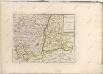

Belfort und die Vogesen aus der Vogelschau

Département du Haut Rhin
1 : 265000 Haut-Rhin (Francie) P. G. Chanlaire et Dumez
Département du Haut Rhin
1 : 250000 Haut-Rhin (Francie) Chanlaire, Pierre-Grégoire P.G. Chanlaire
Freiburg
1 : 200000 1 Karte entworfen und bearbeitet von Woerl ; in Stein gestochen unter seiner Leitung 1831 Herder, Freiburg im Breisgau
Alsatia Et Brisgoia II. Rheni Et VII. Nova Tabula. [Karte], in: Claud. Ptolemaeus. Geographia lat. cum mappis [...], S. 350.
1 Karte aus Atlas Münster, Sebastian [und Ptolemaeus, Claudius]
Carte topographique d'Allemagne contenant une partie du duché de Lorraine, d'Allsas et du margraviat superieur de Baaden-Durlach, l'évêcé de Basel, une partie de la Suisse savoir les cantons de Basel et Solothurn, le territoire de Biel, une partie de la Franche-Comté et de la Bourgogne
1 Karte fait par I.W. Iaeger chez l'auteur, Francfort sur le Mein
Alsatia Et Brisgoia II. Rheni Et VII. Nova Tabula. [Karte], in: Geographia universalis vetus et nova complectens Claudii Ptolemaei Alexandrini enarrationis libros VIII, S. 317.
1 Karte aus Atlas Münster, Sebastian [und Ptolemaeus, Claudius]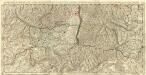
La Haute Alsace Divisée en Balliages et Seigneuries tant de ca que de la Rhin ou sont le Suntgaw le Breisgaw les quatre Villes Forestieres les Montagnes Noires Meridionales de la Souabe et des Suisses levé sur les lieuex pendatles Guerres.
1 : 250000 Mollova mapová sbírka Jaillot, Alexis-Hubert Jaillot, Alexis Hubert

Le Cours du Rhin au dessus de Strasbourg et les Pais adjacens
1 : 240000 Mollova mapová sbírka Delisle, Guillaume Liébaux L'Isle, Guillaume de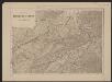
Officielle Eisenbahn-Karte der Schweiz
1 : 250000 Nordwest-Blatt [s.n.]
Cursus Rheni à Basilea usque ad Bonnam III. Sect.
1 : 260000 Mollova mapová sbírka Delisle, Guillaume Homann, Johann Baptista - dědici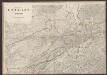
Officielle Eisenbahn-Karte der Schweiz
1 : 250000 Nordwest-Blatt Müllhaupt, Hans Heinrich [Eidg. Stabsbureau]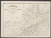
Postkarte der schweizerischen Eidgenossenschaft
1 : 300000 Nordwest-Blatt Dufour, Guillaume Henri ; Stengel, Johann Rudolf ; Mohr, Ernst Rudolf Wurster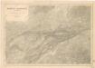
Karte der Schweiz... Blatt I.

Officielle Eisenbahn-Karte der Schweiz
1 : 250000 4 Karten gest. v. H. Müllhaupt Eidg. Stabsbureau, [Bern]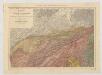
Carte du phénomène erratique et des anciens glaciers du versant nord des Alpes Suisses et de la chaîne du Mont-Blanc
1 : 250000 Nordwest-Blatt Favre, Alphonse Imp. par l'Etabl. topogr. de Wurster, Randegger et Cie.
Alsatia Landgraviatus Ober un Unter-Elsaß Sündgöw, und Brißgöw
1 : 530000 Mollova mapová sbírka Sandrart, Jakob von Sandrart, Jacob von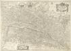
Vtriusquae Alsatiae superioris ac inferioris Nova Tabula
1 : 370000 Mollova mapová sbírka Janssonius, Johannes Janssonius, Johannes I
Alsatia Landgraviatus, cum Suntgoia et Brisgoia [Karte], in: Le théâtre du monde, ou, Nouvel atlas contenant les chartes et descriptions de tous les païs de la terre, Bd. 1, S. 291.
1 Karte aus Atlas Blaeu, Willem Janszoon und Blaeu, Joan Blaeu, Willem Janszoon
Département du Haut Rhin
1 Karte : Kupferdruck ; 48 x 48 cm Houdan au bureau de l'atlas national rue de la Harpe no. 26, et au depôt de cet atlas rue de la Monnoye no. 5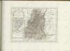

Le Theatre de Bellone :
Mollova mapová sbírka Schenk, Pieter Braakman, Adriaan
Alsatia Superior cum Svntgoia et Brisgoia
1 : 270000 Mollova mapová sbírka Schenk, Pieter Schenk, Peter I
Alsatia Superior cum Svntgoia et Brisgoia
1 : 270000 Mollova mapová sbírka Mercator, Gerhard Janssonius, Johannes I
Alsatia superior cum Suntgoia &. Brisgoia. [Karte], in: Gerardi Mercatoris et I. Hondii Newer Atlas, oder, Grosses Weltbuch, Bd. 1, S. 250.
1 Karte aus Atlas Mercator, Gerhard und Hondius, Jodocus Jansson, Jan
![[Exactissima Helvetiae, Rhaetiae, Valesiae ... tabula]](https://images-2.georeferencer.com/images/iiif/505399271696/full/,300/0/native.jpg)

