Maps of Zürich

Situationsplan vom Stadthaus
1 : 500 1 Plan
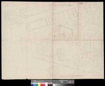
Zürich: Gassenplan der Kleinen Stadt, Blatt 2 (Talgasse-Stadthausquai)
1 : 500 Sulzberger, Johann Jakob (1802-1855), Ingenieur, von Frauenfeld TG
[Zürich]
1 : 1000 12 Pläne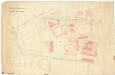
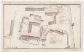
Bauplatz des Stadthauses mit Umgebung; Situationsplan
1 : 500
Projektiertes Postgebäude und neue Brücke mit Quai: Situationsplan (Nr. 2)
1 : 500 Ohne Datumsangabe. Stadler, C., Architekt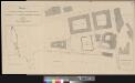
Beilage 1 zum Programm betreffend die Wettbewerbung für Entwürfe zu einem Post- & Telegraphen-Gebäude in Zürich
1 : 500 1 Plan Direktion der eidg. Bauten ; Lith. Ed. Fehlbaum, Bern
Projektiertes Schweizerisches Bundesgebäude (Bundeshaus) in Zürich: Situationsplan
Stadler, Ferdinand (1813-1870), Architekt, von Zürich, in Zürich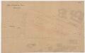
Zürich: Limmat von der Quaibrücke bis zur Münsterbrücke, projektierte Filteranlage; Situationsplan (Zürichsee-Abfluss Nr. 118)
1 : 500 Zollinger, H.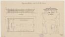
Zürich: Unterhalb des Bauschänzli, schwimmendes Bootshaus des See-Clubs; Grundriss, Ansicht und Situationsplan
1 : 2000 Mit Originalvermerk: Verfügung vom 13. Januar 1882. Ohne Erstellungsdatumsangabe. Schröder, A., Architekt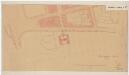
Zürich: Beim Bauschänzli, provisorische Frauenbadeanstalt; Situationsplan (Zürichsee-Abfluss Nr. 112 a)
1 : 500 Mit Originalvermerk: Regierungsbeschluss v. 17. März 1883. Ohne Erstellungsdatumsangabe. Geiser, Arnold (1844-1909), Architekt und Stadtbaumeister von Zürich, von Langenthal und Zürich Hochbaubüro der Stadt Zürich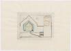
Zürich: Schanzenlehen Nr. 27 Kleine Stadt, beim Halben-Mond zwischen Grendel und Bauhaus (Bauschänzli); Grundriss
Mit Erläuterungen. Müller, Johannes (1733-1816), obrigkeitlicher Ingenieur des Zürcher Stadtstaats, von Zürich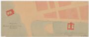
Zürich: Rechtes Limmatufer vom Ausfluss aus dem Zürichsee bis unterhalb des Bauschänzli, Männer- und Frauenbadeanstalt; Situationsplan
1 : 500 Mit Originalvermerk: Regierungsbeschluss vom 19. Mai 1883. Geiser, Arnold (1844-1909), Architekt und Stadtbaumeister von Zürich, von Langenthal und Zürich Hochbaubüro der Stadt Zürich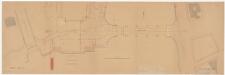
Enge: Linkes Zürichseeufer, Schanzengraben und Quaibrücke; Situationsplan (Zürichsee-Gebiet Nr. 14)
1 : 500 Mit Originalvermerk: Verfügung v. 7. August 1883. Bürkli, Arnold (1833-1894), leitender Ingenieur der Quaibaukommission der Gemeinden Enge, Zürich und Riesbach, von Zürich, in Zürich Bertschinger, Direktion der Quaibauten, in Zürich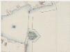
Bei der Bauschanz (Bauschänzli)
Möglicherweise: Breitinger, David (1763-1834), Feinmechaniker und Zeugherr, von Zürich
Enge: Gemeinde; Katasterpläne und Kataster-Ergänzungspläne: Ergänzungsblatt V: Gegend bei Dreikönigstrasse, Stockerstrasse, Alpen-Quai, Claridenstrasse und Glärnischstrasse; Situationsplan
1 : 500 Oppikofer, F.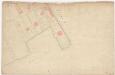
Enge: Gemeinde; Katasterpläne und Kataster-Ergänzungspläne: Blatt V: Gegend bei Stockerstrasse, Dreikönigstrasse, Glärnischstrasse, Rosau und Zürichsee; Situationsplan
1 : 500 Oppikofer, F.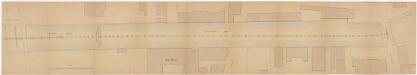
Enge, Zürich: Neue Schanzengrabenbrücke bis zum Bleicherweg, Fassungsleitung im Schanzengraben; Situationsplan (Zürichsee-Abfluss Nr. 124 b)
1 : 200 Mit Originalvermerk: Verfügung v. 20. November 1886. Ohne Erstellungsdatumsangabe. Bauverwaltung der Stadt Zürich, Ingenieurbüro
Zürich: Bauplätze zwischen Fröschengraben und Seegasse bzw. Fröschengraben und Bleicherweg; Grundriss
Ohne Datumsangabe.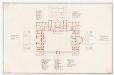
Projektiertes Schweizerisches Bundesgebäude (Bundeshaus) in Zürich: 1. Stock; Grundriss
Stadler, Ferdinand (1813-1870), Architekt, von Zürich, in Zürich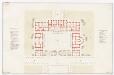
Projektiertes Schweizerisches Bundesgebäude (Bundeshaus) in Zürich: Erdgeschoss; Grundriss
Mit Legende. Stadler, Ferdinand (1813-1870), Architekt, von Zürich, in Zürich
Zürich: Beim Hotel Baur au Lac, eiserne Treppe zum Badehaus; Situationsplan, Ansicht und Grundriss
1 : 200 Katasterkopie. Mit Originalvermerk: Verfügung, dat. 7. Juni 1887. Baur, Th. Katasterbüro, in Zürich
Zürich: Landungsplatz am Fröschengraben beim Tiefenhof; Grundriss
1 : 500 Ohne Datumsangabe.
Zürich: Schanzenlehen Nr. 12 a Kleine Stadt, beim Wall nahe dem Schiffschuppen; Grundriss
Mit Erläuterungen. Müller, Johannes (1733-1816), obrigkeitlicher Ingenieur des Zürcher Stadtstaats, von Zürich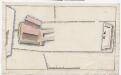
Schiffschuppen: Grundriss
Standort unbekannt, vielleicht in der Altstadt.
Detailplan des Baugartens
1 : 500 1 Plan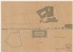
Zürich: Unterhalb des Bauschänzli, neue Frauenbadeanstalt; Situationsplan (Zürichsee-Abfluss Nr. 129)
1 : 500 Mit Originalvermerk: Reg. Beschluss, dat. 27. Oktober 1888. Geiser, Arnold (1844-1909), Architekt und Stadtbaumeister von Zürich, von Langenthal und Zürich Hochbaubüro der Stadt Zürich
Zürich: Neue Poststrasse und Fraumünsterkirche; Grundriss
Handgezeichnete Kopie eines früheren Plans unbekannter Autorschaft.
Zürich: Schanzenlehen Nr. 12 b Kleine Stadt, bei der Batterie vor dem Schiffschuppen; Grundriss
Mit Erläuterungen. Müller, Johannes (1733-1816), obrigkeitlicher Ingenieur des Zürcher Stadtstaats, von Zürich
Zürich: Dem Spital Zürich gehörende Lehen in den Fortifikationswerken; Ansichten, Grundrisse und Schnitte: Schanzenlehen Nr. 12 b Kleine Stadt, bei der Batterie vor dem Schiffschuppen; Grundriss
Mit Erläuterungen. Müller, Johannes (1733-1816), obrigkeitlicher Ingenieur des Zürcher Stadtstaats, von Zürich