Maps of Höchst
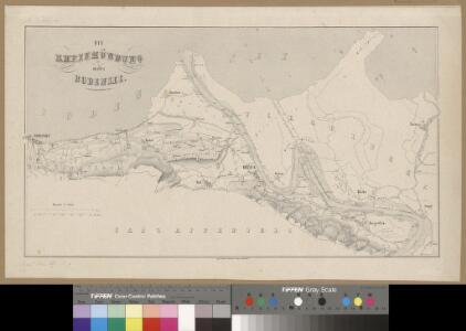
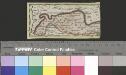
<<Die>> Rheinmündung in den Bodensee
1 : 25000 1 Karte Topogr. Anstalt v. J. Wurster u. Comp., [Winterthur]
Sargans SG bis Rheineck SG: Rheinkorrektionen; Grundrisse: Blatt 4: Rheineck
1 : 25000 Mit Querprofil sowie Kostenvoranschlag nach Gemeinden und Baugegenständen. Joh. Wurster und Comp., in Winterthur
Rhein-Correction
1 : 25000 Blatt Rheineck Topographische Anstalt von Joh. Wurster u. Comp. (Winterthur) J. Wurster u. Comp.
Rhein-Correction
1 : 25000 4 Karten J. Wurster u. Comp., Winterthur
Charte von der Gegend um Bernegg
1 : 50000 1 Karte [Johann Feer?] [Verlag nicht ermittelbar], [Erscheinungsort nicht ermittelbar]
Sankt Margrethen SG, Rheineck SG, Gaissau (Österreich): Rhein, insbesondere die über Jahre entstandenen Ufereinbrüche; Grundriss
Handgezeichnete Kopie eines im Jahr 1769 von Joh. Conrad Römer, Ingenieurhauptmann, verfertigten Originalplans. Spitteler, Sigmund (1732-1818), Ingenieur und Strassenbauinspektor des Kantons Zürich, von Läufelfingen BL und Hottingen
Situation der Fussach-Harder-Bodensee-Bucht und Darstellung ihrer Tiefenmessungen
Teutsch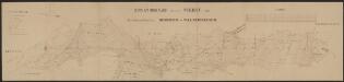
Situationsplan für das Project einer Drahtseilbahn: Rheineck - Walzenhausen
1 : 1000 Fritschi, Emil Emil Fritschi
Thal SG: Teil von Altenrhein; Situationsplan
1 : 1000 Der hier aufgrund der aufgedruckten Ortsangabe zu erwartende Handrissplan von Wilen fehlt, stattdessen ist auf diesem Plan ein Teil von Altenrhein SG abgebildet. Mit Angabe der Namen von privaten Grundeigentümern. Ohne Datumsangabe.
Specialcharte des Rheinthals
1 Karte : Kupferdruck ; 40 x 65 cm Feer; Lips; Custer s.n.
Wandkarte des Cantons Appenzell
1 : 35700 1 Karte auf 4 Blättern J.M. Müller, B. Tanner 1859 Wurster, Winterthur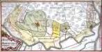
Das Rheinthal
1 Manuskriptkarte : 24 x 48 cm Bernigeroth s.n.
Topographische Karte des Kantons St. Gallen mit Einschluss des Kantons Appenzell (Eschmann-Karte): Blatt Rheineck
1 : 25000 Mit statistischer Tabelle. Aufnahme: Hennet, Théodore Hippolyte (1819-1879), Ingenieur; Merz, Johann Ludwig, andere Schreibweise: Mertz, (1772-1851), Kaufmann und Oberstleutnant, von Herisau AR Stich: Steiner, P.; Leuzinger, Rudolf (1826-1896), Kartograf und Lithograf, von Netstal GL und Mollis GL Gebirgszeichnung und Leitung des Stichs: Ziegler, Jakob Melchior (1801-1883), Kartograf Stich und Druck: Joh. Wurster und Comp., in Winterthur
Topographische Karte des Cantons St. Gallen mit Einschluss des Cantons Appenzell
1 : 25000 Blatt 4 Eschmann, Johannes ; Steiner, P. ; Randegger, Johannes ; Ziegler, Jakob Melchior Topographische Anstalt v. Joh. Wurster & Comp.
Topographische Karte des Cantons St. Gallen mit Einschluss des Cantons Appenzell
1 : 25000 16 Karten aufgenommen von J. Eschmann ... [et al.] ; gestochen von P. Steiner ; Gebirg von J. Randegger ; Gebirgszeichnung u. Leitung des Stiches durch J.M. Ziegler Topographische Anstalt v. Joh. Wurster & Comp., Winterthur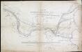
Copie der Meusburgerschen Ubersichts-Karte über den Rheinlauf von Kriesern bis zum Bodensee : Anmerkungen über die bezügl. neuen Flusslängen
Teutsch
Exkursionskarte St. Gallen, Speicher, Trogen, Heiden, Walzenhausen & Umgebung
1 : 50000 E. Wagner, Kartographie Zürich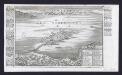
Lindau im Boden See
Bodenehr, Gabriel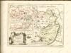
Delineatio aller Quartieren der Statt und Landschaft Zürich
1 : 200000 1 Karte von Joh. Heinr. Freytag
Pagus Helvetiae Abbatiscellanus
1 : 80000 Mollova mapová sbírka Walser, Gabriel Lotter, Tobias Conrad Seutter, Matthäus
Canton Appenzell sive Pagus Helvetiae Abbatiscellanum cum Confinibus recenter delineatus
1 : 90000 Mollova mapová sbírka Walser, Gabriel Homann, Johann Baptista - dědici
Karte des Kantons Appenzell & Umgebung
1 : 100000 1 Karte bearbeitet u. gestochen von E. Wagner [Verlag nicht ermittelbar], [Erscheinungsort nicht ermittelbar]
Reise- u. Touristen-Karte des Kantons Appenzell und Umgebung
1 : 100000 E. Wagner
Pagus Helvetiae abbatiscellanus cum com[m]unitatibus interioribus et exterioribus, ac adjacente Valle Rhenana, accurate delineatus
1 : 115000 Švýcarsko Walser, Gabriel Seutter, Matthäus sumptibus Matth. Seutteri
Karte des Kantons Appenzell
1 : 130000 1 Karte Topogr. Anstalt v. Wurster, Randegger & Cie., Winterthur
Bodensee.
from Spezialkarte der osterreichisch-ungarischen Monarchie.
Hohenems.
from Spezialkarte der osterreichisch-ungarischen Monarchie.
Bodenseekarte
1 : 50000 Ost-Blatt Eidgenössisches Topographisches Bureau Eidg. Topogr. Büreau