Maps of North Yorkshire

Ducatus Eboracensis Pars Occidentalis = The Westriding of Yorke Shire
1 : 270000 [Amstelodami] : [apud Joannem Janssonium]
Generalkarte von Zentraleuropa

EBORACENSIS Comitatus f.61
This is a map of Yorkshire by Christopher Saxton dating from 1577. It forms part of an atlas that belonged to William Cecil Lord Burghley, Elizabeth I’s Secretary of State. Lord Burghley used this atlas to illustrate domestic matters. This map is actually a proof copy of one which forms part of Christopher Saxton’s Atlas of England and Wales. This atlas was first published as a whole in 1579. It consists of 35 coloured maps depicting the counties of England and Wales. The atlas is of great significance to British cartography as it set a standard of cartographic representation in Britain and the maps remained the basis for English county mapping, with few exceptions, until after 1750. During the reign of Elizabeth I, map use became more common, with many government matters referring to increasingly accurate maps with consistent scales and symbols, made possible by advances in surveying techniques. Illustrating the increasing used of maps in government matters, Lord Burghley, who had been determined to have England and Wales mapped in detail from the 1550s, selected the cartographer Christopher Saxton to produce a detailed and consistent survey of the country. The financier of the project was Thomas Seckford, Master of Requests at the Court of Elizabeth I, whose arms appear, along with the royal crest, on each map. Burghley has annotated this map, adding several place names and has drawn a line from Hull to Welton via Willerbye, possibley in connection to Hull's defensive importance. Hull was heavily fortified by Henry VIII and these fortifications were repaired during Elizabeth's reign in readiness for the threatened Spanish invasion.The map was engraved by Augustinus Ryther, the most accomplished member of a team of seven English and Flemish engravers employed to produced the copper plates for the atlas. Saxton, Christopher Ryther, Augustinus
EBORACENSIS Comitatus Sheet 27
This map of the North Riding, Yorkshire is from the 1583 edition of the Saxton atlas of England and Wales. Yorkshire is the only county to be engraved over two separate plates, due to its size. This atlas was first published as a whole in 1579. It consists of 35 coloured maps depicting the counties of England and Wales. The atlas is of great significance to British cartography as it set a standard of cartographic representation in Britain and the maps remained the basis for English county mapping, with few exceptions, until after 1750. During the reign of Elizabeth I map use became more common, with many government matters referring to increasingly accurate maps with consistent scales and symbols, made possible by advances in surveying techniques. Illustrating the increasing used of maps in government matters, Lord Burghley, Elizabeth I’s Secretary of State, who had been determined to have England and Wales mapped in detail from the 1550s, selected the cartographer Christopher Saxton to produce a detailed and consistent survey of the country. The financier of the project was Thomas Seckford Master of Requests at the Court of Elizabeth I, whose arms appear, along with the royal crest, on each map. Here Saxton’s name appears in the decorative scale bar, as does the name of the engraver of this map, Augustine Ryther, the most accomplished of seven English and Flemish engravers employed to produced the copper plates for the atlas. The strap work cartouche is mounted by the Elizabethan coat of arms and the Seckford arms of appear in the bottom left corner. The adjacent counties are named but lack any internal detail, recording only the path of rivers that cross county boundaries. Saxton, Christopher Ryther, Augustine
EBORACENSIS Comitatus f. 27
This map of the North Riding, Yorkshire is from thefirst edition of the Saxton atlas of England and Wales. Yorkshire is the only county to be engraved over two separate plates, due to its size. This atlas was first published as a whole in 1579. It consists of 35 coloured maps depicting the counties of England and Wales. The atlas is of great significance to British cartography as it set a standard of cartographic representation in Britain and the maps remained the basis for English county mapping, with few exceptions, until after 1750. During the reign of Elizabeth I map use became more common, with many government matters referring to increasingly accurate maps with consistent scales and symbols, made possible by advances in surveying techniques. Illustrating the increasing use of maps in government matters, Lord Burghley, Elizabeth I’s Secretary of State, who had been determined to have England and Wales mapped in detail from the 1550s, selected the cartographer Christopher Saxton to produce a detailed and consistent survey of the country. The financier of the project was Thomas Seckford Master of Requests at the Court of Elizabeth I, whose arms appear, along with the royal crest, on each map. Here Saxton’s name appears in the decorative scale bar, as does the name of the engraver of this map, Augustine Ryther, the most accomplished of seven English and Flemish engravers employed to produced the copper plates for the atlas. The strap work cartouche is mounted by the Elizabethan coat of arms and the Seckford arms of appear in the bottom left corner. The adjacent counties are named but lack any internal detail, recording only the path of rivers that cross county boundaries. Saxton, Christopher
Ducatus Eboracensis Anglice York Shire. [Karte], in: Theatrum orbis terrarum, sive, Atlas novus, Bd. 4, S. 439.
1 Karte aus Atlas Blaeu, Joan Blaeu, Willem Janszoon
Ducatus Eboracensis Anglice York Shire. [Karte], in: Le théâtre du monde, ou, Nouvel atlas contenant les chartes et descriptions de tous les païs de la terre, Bd. 4, S. 379.
1 Karte aus Atlas Blaeu, Willem Janszoon und Blaeu, Joan Blaeu, Willem Janszoon
Provincia Eboracensis Yorke-Shire [Karte], in: Gerardi Mercatoris et I. Hondii Newer Atlas, oder, Grosses Weltbuch, Bd. 1, S. 87.
1 Karte aus Atlas Mercator, Gerhard und Hondius, Jodocus Jansson, Jan
Ducatus Eboracensis Anglice York Shire. [Karte], in: Theatrum orbis terrarum, sive, Atlas novus, Bd. 4, S. 439.
1 Karte aus Atlas Blaeu, Joan Blaeu, Willem Janszoon
Ducatus Eboracensis. Anglice Yorkshire. [Karte], in: Novus atlas absolutissimus, Bd. 8, S. 24.
1 Karte aus Atlas Janssonius Offizin
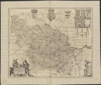
DVCATVS | EBORACENSIS | Anglice | YORK SHIRE.
[Amsterdam : Joan Blaeu]
Ducatus Eboracensis Pars Occidentalis; The Westriding Of Yorke Shire. [Karte], in: Novus atlas absolutissimus, Bd. 8, S. 27.
1 Karte aus Atlas Janssonius Offizin
The County of York Survey'd in MDCCLXVII, VIII, IX, and MDCCLXX
London : T. Jefferys

Ducatus Eboracensis anglice Yorkshire
1 : 430000 [Amstelodami] : [apud Joannem Janssonium]
Ducatus Eboracensis Pars Occidentalis; The Westriding Of Yorke Shire. [Karte], in: Theatrum orbis terrarum, sive, Atlas novus, Bd. 4, S. 442.
1 Karte aus Atlas Blaeu, Joan Blaeu, Willem Janszoon
Ducatus Eboracensis Pars Occidentalis; The Westriding Of Yorke Shire. [Karte], in: Theatrum orbis terrarum, sive, Atlas novus, Bd. 4, S. 442.
1 Karte aus Atlas Blaeu, Joan Blaeu, Willem Janszoon
Ducatus Eboracensis Pars Occidentalis; The Westriding Of Yorke Shire. [Karte], in: Le théâtre du monde, ou, Nouvel atlas contenant les chartes et descriptions de tous les païs de la terre, Bd. 4, S. 382.
1 Karte aus Atlas Blaeu, Willem Janszoon und Blaeu, Joan Blaeu, Willem Janszoon
An accurate map of the County of York
1 Karte : Kupferdruck ; 52 x 69 cm Bowen; Hinton; Walker sold by J Hinton at the Kings Arms in St. Pauls Church Yard
Dvcatvs Eboracensis. anglice Yorkshire
1 Karte : Kupferdruck ; 37 x 47 cm Valck; Schenk venundantur â Gerardo Valk et Petro Schenk
Dvcatvs Eboracensis anglice York Shire
1 Karte : Kupferdruck ; 38 x 49 cm Blaeu Joan Blaeu
Sheet 3 England, North East, uit: Maps of England & Wales : scale 4 miles to 1 inch / Ordnance Survey
1 : 253440 titelvariant: Maps of England and Wales; Annotatie: Titel op cassette; Met bladoverzicht op de achterzijde van de cassette; Annotatie geografische gegevens: Hoogtelijneninterval 200 ft Ordnance Survey, United Kingdom Southampton : Ordnance Survey Office
England and Wales 1:253,440
Ordnance Survey
delineation of the strata of England and Wales, with part of Scotland
1 : 320000 Blatt 4 Smith, William Cary
DVCATVS | EBORACENSIS | PARS OCCIDENTALIS; | THE WESTRIDING OF | YORKE SHIRE.
[Amsterdam : Joan Blaeu]
Dvcatvs Eboracensis pars occidentalis
1 Karte : Kupferdruck ; 39 x 47 cm Valck; Schenk venundantur â Gerardo Valk et Petro Schenk
Dvcatvs Eboracensis pars occidentalis
1 Karte : Kupferdruck ; 37 x 48 cm Blaeu Joan Blaeu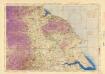
Ordnance Survey of England and Wales (Aeronautical map)
Great Britain. War Office. General Staff. Geographical Section [London] : [Air Ministry],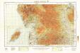
England and Wales 1:253,440
Ordnance Survey