Maps of Gelderland

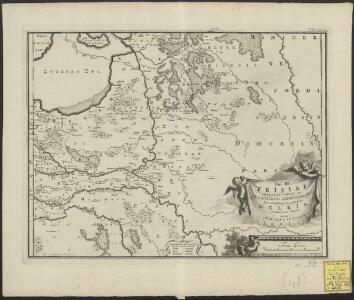
Pars III Frisiae haereditariae seu Trajectini episcopatus dicio, cis et ultra Isalam, maxima ex parte, una cum Gelria, ad Henricorum tempora
1 : 560000 auctore Mensone Alting Ger. de Broen fecit. [Amstelaedami] : [apud Henricum Wetstenium]
Geldria et Transysulana [Karte], in: Gerardi Mercatoris Atlas, sive, Cosmographicae meditationes de fabrica mundi et fabricati figura, S. 305.
1 Karte aus Atlas Mercator, Gerhard Montanus, Petrus

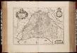
Geldria et Transysulana
1 : 400000 per Gerardum Mercatorem. [Amsterdam] : [Henricus Hondius]
Clivia dvcatvs et Ravestein dominivm
1 : 230000 Kleve-oblast (Německo)
[Kaart], uit: Gelderland / door W.J. Geerling
1 : 200000 titelvariant: Gemeentekaart van Gelderland; Annotatie: Omslagtitel: Gemeentekaart van Gelderland Geerling, W.J. 's-Gravenhage : Smulders
[Kaart], uit: Overijssel en Gelderland
1 : 300000 titelvariant: Midden-Nederland; Ten Brink's reiskaart van Overijssel, Gelderland, Utrecht (oostelijk) en 't Gooi; Annotatie: Ook onder de titel: Midden-Nederland; Titel op omslag: Ten Brink's reiskaart van Overijssel, Gelderland, Utrecht (oostelijk) en 't Gooi Arnhem : Ten Brink
Ducatus Geldriae et Zutphaniae comitatus
1 : 500000 per Nicolaum Visscher. [Amsterdam] : N. Visscher
Ducatus Geldria et Zutphania Comitatus. [Karte], in: Novus atlas absolutissimus, Bd. 3, S. 82.
1 Karte aus Atlas Janssonius Offizin
[Kaart], uit: Amsterdam - Nijmegen
1 : 200000 Annotatie: Omslagtitel; Annotatie geografische gegevens: Legenda in het Frans, Engels en Nederlands Amsterdam : Nederlandsche Bandenindustrie Michelin
Ducatus Geldriae et Zutphaniae comitatus
1 : 305000 per Nicolaum Visscher. [Amsterdam] : nunc apud P. Schenk Junior
Ducatus Gelriae pars quarta quae est Arnhemiensis, sive Velavia / [Joannes Janssonius]
1 : 275000 Annotatie: Het eerst verschenen in: Novi Atlantis Anhang ... - Amstelodami : apud Ioannem Ianssonium, 1641; Origineel is Blad 60 in atlas factice; Annotatie geografische gegevens: Zuidoost boven Janssonius, Joannes (jr.) (1588-1664) Amstelodami : apud Johannem Janssonium
DUCATUS GELDRIA et ZUTPHANIA Comitatus
1 : 340000 Geldern-oblast (Německo) Visscher, Nicolaus gedruckt by Nicolaes Visscher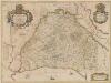
Ducatus Gelriae pars Quarta Quae est Arnhemiensis, Sive Velavia. [Karte], in: Novus atlas absolutissimus, Bd. 3, S. 97.
1 Karte aus Atlas Janssonius Offizin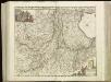
[94][95] Ducatus Geldriae et Comitatus Zutphaniae, tabula, uit: Atlas sive Descriptio terrarum orbis
Annotatie: Gedigitaliseerde versie. Amsterdam. Heiloo : Picturae (vervaardiger), 2015. tiff-bestand. Gedigitaliseerd: 07-01-2015; Origineel: Universiteitsbibliotheek Vrije Universiteit (XL.05127.-) ; Netherlands; Titelpagina ontbreekt Wit, Frederik de Amsterdam : Frederick de Wit
Ducatus Geldriae et comitatus Zutphaniae nova tabula in tetrarchias Noviomagi, Arnhemii, Ruremondae et Zutphaniae distincta ...
1 : 350000 I. Condet sc. Amstelodami : edita a Covens et Mortier
Ducatus Geldriae, et Comitatus Zutphaniae, tabula
1 : 310000 auctore F. de Wit. Gedruckt 't Amsterdam : bij I. Covens en C. Mortier
Ducatus Geldriae nova tabula in tetrarchias Noviomagi, Arnhemii, Ruremondae ac Zutphaniae Comitatum
1 : 350000 distincta et edita a Tob. Conrado Lottero geographo. Aug[ustae] Vind[elicorum] : a Tob. Conrado Lottero
Ducatus Geldriae Batavae et Hispanicae, in tetrarchias Noviomagi, Arnhemii, Ruremondae & Zutphaniae comitatus
1 : 320000 distinctae et editae, a Carolo Allard A.A. f. [= Abraham Allard fecit.] Amst. Bat. : Carolus Allard
Charte von Gelderland und der dazugehörigen Grafschaft Zutphen
1 : 240000 Zutphen (Nizozemsko) Güssefeld, Franz L. Homannischen Erben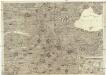
Grundrichtiger Entwurff und Abriß eines Theils des Rheinstroms von Orsoyan bis zu dessen außlauff ins Meer und beyderseits angelegner oder angzäntzender Landschafften worbey auch eine leswürdige Beschreibung solcher Länder, Stätte und Vestungen in einem kurzgefassten Buchlein zu finden
Nizozemsko I.H.S. Hipschmann, Sigmund Gabriel Johann Hofmann
Ducatus Geldriae nova tabula in tetrarchias Noviomagi, Arnhemii, Ruremondae, in Zutphaniae comitatûm distincta
1 : 320000 et edita à auctore Joachimo Ottens geographo Amstelodamensi. Amstelodami : edita a auctore Joachim Ottens
Ducatus Geldriae nova tabula in tetrarchias Noviomagi, Arnhemii, Ruremondae ac Zutphaniae Comitatum
1 : 350000 distincta et edita a Tob. Conrado Lottero geographo Aug[ustae] Vind[elicorum] : a Tob. Conrado Lottero
Ducatus Geldriae Nova Tabula
1 : 330000 Mollova mapová sbírka Ottens, Joachim
Nouvelle discription du duché de Gueldres comprennant aussy le comté de Zutphen avecq le duché de Cleves, la Mayerie de Bois-le-Duc etc. = Nieuwe beschryvinge van het Hertogdom van Gelre begrypende mede het Graefschap Zutphen met het Hertogdom van Cleef en andere bygelegen landen.
1 : 165000 A Amsterdam : chez Jean Cóvens et Corneille Mortier
Ducatus Geldriae, Et Comitatus Zuphaiae, Tabula
1 : 340000 Mollova mapová sbírka Wit, Frederik de Covens, Johannes I
5de blad Bladwijzer, uit: Topographische kaart van de provincie Gelderland / vervaardigd door W. Kuyk Jzn. ; op steen gegrav. door A. Bayly en J.M. Huart ; gelithogr. door J.M. Huart
1 : 50000 titelvariant: Kaart der provincie Gelderland; Annotatie: Omslagtitel: Kaart der provincie Gelderland; Vervaardigd in opdracht van de Staten van Gelderland; Met register van trigonometrische punten (bl. 4) en bladwijzer (bl. 5) W. Kuyk Jzn fl. 1843; Bayly, A.; Huart, J. M. [S.l. : s.n.]