Maps of South Holland

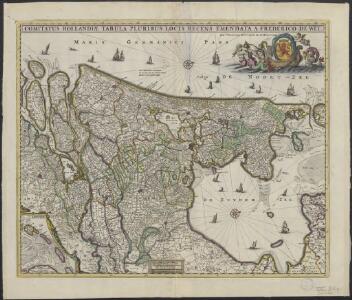
Comitatus Hollandiae tabula
1 : 300000 pluribus locis recens emendata a Frederico de Wit. [Amsterdam] : ex officina I. C
Comitatus Hollandiæ tabula pluribus locis recens
1 : 300000 pluribus locis recens emendata a Frederico de Wit. Gedruckt 't Amsterdam : by Frederick de Wit ...
Comitatus Hollandiæ tabula pluribus locis recens
1 : 300000 pluribus locis recens emendata a Nicolao Visscher. [Amsterdam] : nunc apud Petrum Schenk junior
Comitatus Hollandiæ tabula pluribus locis recens
1 : 320000 pluribus locis recens emendata a Justo Danckerts. [Amsterdam] : Justus Danckerts
Comitatus Hollandiae tabula / pluribus locis recens emendata a Nicolao I. Visschero
1 : 300000 Annotatie: Origineel is Blad 50 in atlas factice; Annotatie geografische gegevens: West boven Visscher, Claes Jansz. [Amsterdam : C.J. Visscher excudit]
Comitatus Hollandiae tabula
1 : 300000 pluribus locis recens emendata a Nicolao Visscher. [Amsterdam : Nicolaus Visscher]
Condado de Olanda
1 : 1000000 [Jacques Harrewijn] [Madrid] : [Francisco Laso]
Comitatus Hollandiæ tabula pluribus locis recens
1 : 300000 pluribus locis recens emendata a Francisco Caroli J. Bormeester. eccu. Amstel' : Petrum Schenk exc.
Comitatus Hollandiæ
1 : 980000 Harrewijn fecit. [Antwerpen] : J. Peeters. ex.
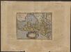
HOLLANDIA | COMITATVS
Apud Guiljelmum Blaeu
Comitatus Hollandiæ nova descriptio, ex optimis & novißimis delineationibus designata
1 : 350000 Geeraerd Coeck sculpsit. [Amsterdam] : [apud Gerardum Valk, et Petrum Schenk]
Comitatus Hollandiæ tabula denuo in lucem
1 : 300000 edita à Carolo Allard Amstelodami. 't Amsterdam : gedruckt by, Carel Allard. caart en constverkooper op den Dam inde Caartwinkel
Comitatus Hollandiae novissima descriptio
1 : 760000 designatore Balth. Flor. a Berckenr. Amstelodami : sumptibus Henrici Hondii.
Comitatus Hollandiae pluribus locis recens emendata / a Frederico de Wit
1 : 300000 Annotatie: Deze derde staat van de koperplaat is te herkennen aan het cijfer "I" rechtsboven (net als de tweede staat) en aan het feit dat de plattegrond van Amsterdam is ingevuld (bij de eerste en tweede staat van de koperplaat is dit niet het geval); Annotatie geografische gegevens: West boven Wit, Frederik de Amsterdam : Frederick de Wit

Comitatus Hollandiæ nova descriptio, ex optimis & novißimis delineationibus designata
1 : 350000 Geeraerd Coeck sculpsit. Amstelodami : apud Joannem Janssonium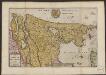
Le Comte de Hollande
1 : 750000 auctore Baltha: Florentius de Berkenrode. [Amsterdam] : La Feuille exc.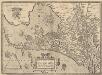
Hollandiae Antiquorum Catthorum Sedis Nova Descriptio [Karte], in: Theatrum orbis terrarum, S. 192.
1 Karte aus Atlas Ortelius, Abraham Vrients, Jan Baptista
Comitatus Hollandiæ nova descriptio
1 : 900000 A: de Winter schulp. A Amsterdam : chez Henri Wetstein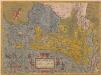
Hollandiae Antiquorum Catthorum Sedis Nova Descriptio [Karte], in: Theatrum orbis terrarum, S. 52.
1 Karte aus Atlas Ortelius, Abraham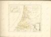
Hollandiæ comitatus Hollant grafschaftt
1 : 1000000 [Frans Hogenberg] [Keulen] : [s.n.]
Comitatus Hollandiae Tabula Pluribus Locis [...] [Karte], in: Novus atlas absolutissimus, Bd. 3, S. 162.
1 Karte aus Atlas Janssonius Offizin
Hollandia Comitatus
1 : 520000 [Caspar Merian] [Frankfurt am Main] : Caspar Merian]
Hollandia
1 : 1100000 [Zacharias Heyns] [Amsterdam] : [Zacharias Heyns]
Les provinces de Hollande et d'Utrecht
1 : 800000 [Georges-Louis Le Rouge] [Paris] : G. Le Rouge

Charte von Holland
1 : 300000 nach astronomischen Beobachtungen, den Messungen des Schnellius &.c.c. und den vorzüglichsten Specialcharten neu entworfen von F.L. Güssefeld. Nürnberg : bey den Hom[ännischen Erben]
Comitatus Hollandiae tabula
1 : 300000 pluribus locis recens emendata a Francisco Caroli J. Bormeester. eccu. Amstel' : Petrum Schenk exc.