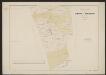
Maps of Amsterdam
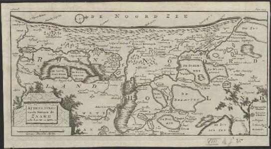
Afbeeldinge vande reviere de Zaane inde Jare MC en MCCL &c.
1 : 300000 [S.l.] : [s.n.]
Vernieuwde kaart van Noordholland en Westfriesland, benevens het voornaamste gedeelte van Rhynland en daar aan grenzende landen
1 : 80000 met alle naauwkeurigheid gevolgd naar de caerte van Joost Jansz Beelsnyder Ao. 1575, door Jan van Jagen, 1778 C. Bogerts sculps. Te Amsterdam : uitgeg. by Yntema en Tieboel
Nieuwe kaart van het departement van Texel, verdeeld in VII ringen
1 : 400000 C. Covens del. C. van Baarsel sculp. Te Amsterdam : bij Mortier Covens en Zoon
Algemeen kaartje, aantonende de uitgestrektheid en verdeling der bladen van de Kaart van een gedeelte der Departementen van Amstelland, Maasland en Utrecht
1 : 530000 onder directie en naar de geodesische waarnemingen van ... C.R.T. Krayenhoff ... te zamen gesteld en getekend door ... J.E. van Gorkum C. van Baarsel, sculp. Amsterdam : Mortier, Covens en Zoon
La Rhinlande Amstellande et terres circõvosines
1 : 300000 auctore Balt[hasar] Flo: a Berkêrode. [Amsterdam] : [Jacob Aertsz. Colom]
Rhinolandiæ Amstelandiæ et circumjacent. aliquot territoriû accurata descriptio
1 : 360000 Auctore Balth. Florentio a Berckenrode. Amstelodami : sumptibus Henrici Hondii.

Rhenolandia, Amstelandia et circumjacentia aliquot territoria, cum aggeribus omnibus, terminisq[ue] suis / accurate et distincte edita per Nicolaum Visscher
1 : 180000 Annotatie: Cum privilegio Ordinum Hollandiae et West-Frisiae; Met opdracht van Nicolaus Visscher aan Johannes Hudde; Annotatie geografische gegevens: West boven; Met 2 schaalstokken Nicolaes Jansz Visscher sr 1618-1679 [Amsterdam : Nicolaus Visscher]
Rhenolandia, Amstelandia Et Circumiacentia aliquot Territoria, cum Aggeribus omnibus, Terminisque suis. [Karte], in: Novus atlas absolutissimus, Bd. 3, S. 179.
1 Karte aus Atlas Janssonius Offizin
Rhenolandia, Amstelandia et circumjacentia aliquot territoria, cum aggeribus omnibus terminisque suis
1 : 180000 accurate et distincte edita per Nicolaum Visscher. [Amsterdam] : [N. Visscher]
Hollandiae Pars Septentrionalis, Vulgo Westvriesland en 'T Noorder Quartier. [Karte], in: Le théâtre du monde, ou, Nouvel atlas contenant les chartes et descriptions de tous les païs de la terre, Bd. 1, S. 422.
1 Karte aus Atlas Blaeu, Willem Janszoon und Blaeu, Joan Blaeu, Willem Janszoon
HOLLANDIÆ | PARS SEPTENTRIONALIS, | Vulgo | WESTVRIESLAND en | 'T NOORDER QVARTIER.
Amsterdami | Apud Guiljelmum et Ioannem Blaeu.
Hollandiæ pars septentrionalis, vulgo Westvriesland en 't Noorder Quartier
1 : 115000 [Willem Jansz. en Joan Blaeu] Amsterdami : apud Guiljelmum et Joannem Blaeu
Hollandiae Pars Septentrionalis, Vulgo Westvriesland en 'T noorder Quartier. [Karte], in: Theatrum orbis terrarum, sive, Atlas novus, Bd. 1, S. 424.
1 Karte aus Atlas Blaeu, Joan Blaeu, Willem Janszoon
Hollandiae Pars Septentrionalis, Vulgo Westvriesland en 'T Noorder Quartier. [Karte], in: Novus Atlas, das ist, Weltbeschreibung, Bd. 1, S. 391.
1 Karte aus Atlas Blaeu, Joan Blaeu, Willem Janszoon
Rhinolandiae, Amstelandiae et circumiacent. aliquot territorumque, accurat desc. [Karte], in: Gerardi Mercatoris et I. Hondii Newer Atlas, oder, Grosses Weltbuch, Bd. 1, S. 451.
1 Karte aus Atlas Mercator, Gerhard und Hondius, Jodocus Jansson, Jan
Rhinolandiae, Amstelandiae, et circumiacent. aliquot territorium, accurata desc. [Karte], in: Novus atlas absolutissimus, Bd. 3, S. 174.
1 Karte aus Atlas Janssonius Offizin
Rhinolandiae, Amstelandiae, et circumiacent. aliquot territorioräu accurata desc. / auct. Balthazaro Flor. a Berckenrode
1 : 100000 Berckenrode, Balthasar Florisz. van Amstelodami : apud Frederick de Wit
Rhenolandia, Amstelandia et circumjacentia aliquot territoria, cum aggeribus omnibus, terminisq. suis
1 : 180000 accurate et distincte edita per Nicolaum Visscher. [Amsterdam] : nunc apud Petrum Schenk Junior
Rhinolandiae, Amstelandiae, et circumjacent. aliquot territoriorũ, accurata desc.
1 : 100000 Auct. Balthazaro Flor. a Berckenrode. Amstelodami : Sumptibus Henrici Hondii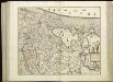
[102[104] Rhinolandiae, Amstelandiae, ..., uit: Atlas sive Descriptio terrarum orbis
Annotatie: Gedigitaliseerde versie. Amsterdam. Heiloo : Picturae (vervaardiger), 2015. tiff-bestand. Gedigitaliseerd: 07-01-2015; Origineel: Universiteitsbibliotheek Vrije Universiteit (XL.05127.-) ; Netherlands; Titelpagina ontbreekt Wit, Frederik de Amsterdam : Frederick de Wit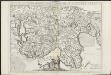
Parte septtentrionale dell'Hollanda, vulgo Westvriesland en tNoorder quartier
1 : 120000 nel laboratorio del P. cosmografo Coronelli, in Venetia. Venetia : Coronelli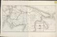
Algemeene kaart van het Groot Amsterdamsch Kanaal door Noord Holland: ... ondernomen in 1819 en voltooid in 1825
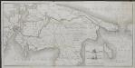
Algemeene kaart van het Groot Amsterdamsch Kanaal door Noord Holland : voor de koopvaardijvaart en s' Konings Marine tusschen het Y en de reede van Texel, ondernomen in 1819 en voltooid in 1825
1 : 85000 gegraveerd naar eene kaart daar toe met goedvinden van Z.M. den Koning verstrekt, door den staatsraad ... J. Blanken Jansz. C. van Baarsel & Zoon sculps Te Amsterdam : bij de Wed. Gerd. Hulst van Keulen
Kennemaria et Westfrisia vulgo et vernacule Noord-Holland tam in minores quam praecipuas ditiones
1 : 150000 peraccurate distincta et edita per Nicolaum Visscher Amst. Bat. Amst. Bat. : per Nicolaum Visscher
't Hoogh-Heemraetschap vande uytwaterende sluysen in Kennemerlandt ende West-Vrieslandt

Hollandiae pars Septentrionalis, Vulgo Westvriesland en 'tnoorder quartier. [Karte], in: Novus atlas absolutissimus, Bd. 3, S. 182.
1 Karte aus Atlas Janssonius Offizin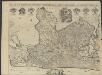
't Hoog-Heemraetschap van de uytwaterende sluysen in Kennemerlant ende West-Frieslant
1 : 60000 [opgemeten door Jan Jansz. Dou] [S.l] : [s.n]