Maps of Overijssel

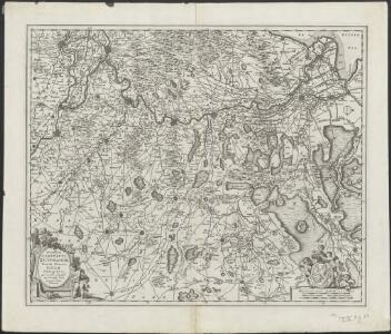
Novissima Comitatus Zutphaniae totiusque fluminis Isulae descriptio
1 : 190000 per Nic. Visscher. [Amsterdam : Nicolaus Visscher]
Novissima Comitatus Zutphaniae totiusque fluminis Isulae descriptio
1 : 190000 per Nic. Visscher. [Amsterdam : Nicolaus Visscher]
Novissima Comitatus Zutphaniae totiusq fluminis Isulae descriptio / [Nicolaes Visscher]
1 : 193000 Annotatie: Origineel is Blad 59 in atlas factice; Annotatie geografische gegevens: West boven Visscher, Nicolaes (1649-1702) [Amsterdam : ex officina Nicolai Visscher]
Novissima Comitatus Zutphaniae, Totiusque Fluminis Insulae Descriptio [Karte], in: Novus atlas absolutissimus, Bd. 3, S. 94.
1 Karte aus Atlas Janssonius Offizin
Comitatus Zutphaniae sive Geldriae Tetrachiae Zutphaniensis Isalaeque fluvii correctissima descriptio
1 : 170000 de novo revisa, accurate divisa et edita per F. de Witt Amstelodami. Amstelodami : apud I. Covens et C. Mortier
[95][96] Comitatus Zutphaniae et fluminis insulae nova, uit: Atlas sive Descriptio terrarum orbis
Annotatie: Gedigitaliseerde versie. Amsterdam. Heiloo : Picturae (vervaardiger), 2015. tiff-bestand. Gedigitaliseerd: 07-01-2015; Origineel: Universiteitsbibliotheek Vrije Universiteit (XL.05127.-) ; Netherlands; Titelpagina ontbreekt Wit, Frederik de Amsterdam : Frederick de Wit
Novissima Comitatus Zutphaniae, Totiusque Fluminis Isulae Descriptio
1 : 190000 Mollova mapová sbírka Visscher, Nicolaes Schenk, Peter II
Comitatus Zutphaniae
1 : 180000 Mollova mapová sbírka Wit, Frederik de Covens, Johannes I
Comitatus Zutphania
1 : 400000 Nizozemsko Visscher, Claes Jansz. Vißcher
Ducatus Geldriae et Zutphaniae Comitatus
1 : 340000 Mollova mapová sbírka Visscher, Nicolaes Schenk, Peter II
Het Graeffschap Zutphen : driede vierdeel van Gelderlandt
1 : 200000 [Nicolaas van Geelkercken] [S.l.] : [s.n.]
Zwolle 56, uit: Special-Karte von Mittel-Europa / nach amtlichen Quellen bearbeitet von W. Liebenow
1 : 300000 titelvariant: W. Liebenow's Mittel-Europa; Annotatie: Titel boven de bladen: W. Liebenow's Mittel-Europa Johannes Wilhelm Liebenow 1822-1897 Frankfurt a. M. : Ludwig Ravenstein
Zutphania Comitatus. [Karte], in: Le théâtre du monde, ou, Nouvel atlas contenant les chartes et descriptions de tous les païs de la terre, Bd. 1, S. 408.
1 Karte aus Atlas Blaeu, Willem Janszoon und Blaeu, Joan Blaeu, Willem Janszoon
Zwolle 56, uit: [W. Liebenow's Special-Karte von Mittel-Europa]
1 : 300000 titelvariant: W. Liebenow's Mittel-Europa; Annotatie: Titel boven de bladen: W. Liebenow's Mittel-Europa Johannes Wilhelm Liebenow 1822-1897 Hannover : Hermann Oppermann
Zutphania Comitatus. [Karte], in: Novus Atlas, das ist, Weltbeschreibung, Bd. 1, S. 379.
1 Karte aus Atlas Blaeu, Joan Blaeu, Willem Janszoon
Zutphania Comitatus. [Karte], in: Theatrum orbis terrarum, sive, Atlas novus, Bd. 1, S. 410.
1 Karte aus Atlas Blaeu, Joan Blaeu, Willem Janszoon
Comitatus Zutphania [Karte], in: Novus atlas absolutissimus, Bd. 3, S. 91.
1 Karte aus Atlas Janssonius Offizin
Kaart der Provincie Overijssel, afgedeeld in III administratieve kwartieren
1 : 240000 gegraveerd door Hs. en Dl. Veelwaard Junior. Te Amsterdam : bij Mortier, Covens & Zoon


Comitatus Zutphania
1 : 160000 excudit Joannes Janssonius. [Amsterdam] : [Joannes Janssonius]
ZVTPHANIA | COMITATVS, | sive | Ducatus Gelriæ | TETRARCHIA | Zutphaniensis
[Amsterdam : Joan Blaeu]
Nieuwe kaart van 't kwartier Zutphen
1 : 175000 J. Keizer fecit 1741. Uitgegeven te Amsterdam : by Isaak Tirion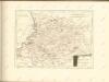
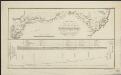
Kaartje van de rivier den IJssel, waarop aangewezen zijn, de nieuw te graven mond met de vereischte afsnijdingen en verbreedingen, welke dezelve zal moeten ondergaan, ten einde, bij eventuele afsluiting van de rivier de Leck al het water en ijs te kunnen ontvangen ...
1 : 200000 gegraveerd door C. van Baarsel en Zoon. [S.l] : [s.n.]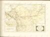
Central Europe 1:1,000,000, Bocholt
Sheet P1 of the 287 sheet series: Central Europe. 1 : 100,000. G.S.G.S. No. 4416. AMS. M641, M651, M671. [London?] ; Washington, D.C. : War Office : Army Map Service, U.S. Army.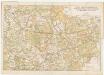
[Kaart], uit: Kaart van de rijwielpaden, wandelwegen en ruiterwegen in Twenthe en Salland
1 : 100000 's-Gravenhage [etc.] : A.N.W.B., Toeristenbond voor Nederland
Bijlage 8, uit: Eindverslag over de onderzoekingen en uitkomsten van den Dienst der Rijksopsporing van Delfstoffen in Nederland, 1903-1916
Annotatie: Met lit. opg Departement van Landbouw, Nijverheid en Handel. Dienst der Rijksopsporing van Delfstoffen ['s-Gravenhage : Martinus Nijhoff]