Maps of Smith County

Smith Center
1 : 125000
Smith Center
1 : 125000
Smith Center
1 : 125000
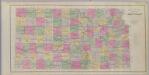
Smith Co., Kansas.
1 : 140800 L.H. Everts & Co.
Gaylord SW
1 : 24000
Harlan
1 : 24000
Portis
1 : 24000
Downs North
1 : 24000
Downs North
1 : 24000
Cedar
1 : 24000
Gaylord
1 : 24000
Portis NE
1 : 24000
Portis NW
1 : 24000
Athol
1 : 24000
Smith Center
1 : 24000
Bellaire
1 : 24000
Lebanon
1 : 24000
Bachelors Run
1 : 24000
Reamsville
1 : 24000
Mc Cracken Branch
1 : 24000
Cora
1 : 24000
Smith Center
1 : 100000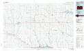
Smith Center
1 : 100000
Beloit
1 : 250000
Beloit
1 : 250000
Beloit
1 : 250000
Beloit
1 : 250000
Osborne Co. ; Osborne, Bethany (Portis), Kansas.
1 : 142560 Pearson, Alva H.
Campaign map of the department of the Platte. sheet no. 1 : comprising that portion of Nebraska
1 : 600000 Jones, William Albert 1841-1914; États-Unis. Corps of Engineers [Omaha, Nebr.] : Engineer Dept., U.S. Army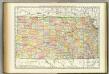
Kansas.
1 : 1030000 Rand McNally and Company