Maps of Westport
Westport
1 : 25000
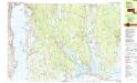
Tiverton
1 : 24000
Tiverton
1 : 24000
Tiverton
1 : 24000
Tiverton
1 : 24000
Tiverton
1 : 31680
Tiverton
1 : 31680
Tiverton
1 : 31680
Fall River
1 : 62500
Fall River
1 : 62500
Fall River
1 : 62500
Fall River
1 : 62500
Fall River
1 : 62500
Fall River
1 : 62500
Fall River
1 : 62500
Fall River
1 : 62500
Fall River
1 : 62500
34. Fall River sheet.
1 : 62500 Massachusetts. Topographical Survey Commission
Fall River
1 : 62500
R.I. sheet 6.
1 : 62500 Geological Survey (U.S.)
Map of the town of Tiverton, Newport County, R.I
1 : 21200 Borden, William G Lith. of Friend & Aub
Fall River quadrangle, Massachusetts
1 : 62500 Geological Survey (U.S.) U.S. Geological Survey
Bristol County.
1 : 158400 Gray, Ormando Willis; Walling, H. F.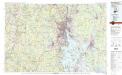
Providence
1 : 100000
A topographical chart of the bay of Narraganset in the province of New England : with all the isles contained therein, among which Rhode Island and Connonicut have been particularly surveyed, shewing the true position & bearings of the banks, shoals, rocks &c. as likewise the soundings, to which have been added the several works & batteries raised by the Americans
1 : 50000 Blaskowitz, Charles Engraved & printed for Wm. Faden
Siege of Newport, Rhode Island.
1 : 140000 Marshall, John
Position des Armees Americaine et Britannique, au Siege de Newport, et a l'affaire de 29 Aout 1778.
1 : 150000 Marshall, John
Topographical Chart of the Bay of Narraganset.
1 : 50700 Faden, William, 1750?-1836
Map of the town of Dartmouth, Bristol County Mass. : made by order of the town
1 : 25000 Walling, Henry Francis, 1825-1888 [s.n.]

