Maps of Chihuahua

Kent
1 : 125000
Boracho
1 : 24000
Fencepost Draw
1 : 24000
Kent
1 : 24000
Gomez Peak
1 : 24000
Gomez Peak
1 : 24000
East Hunter Canyon
1 : 24000
Iron Mountain
1 : 24000
Panther Canyon
1 : 24000
San Martine
1 : 24000
Dome Hill
1 : 24000
Hopper Draw West
1 : 24000
Hopper Draw East
1 : 24000
Burnt Spring Hills SE
1 : 24000
Loneman Mountain
1 : 24000
Dellahunt Draw West
1 : 24000
Dellahunt Draw East
1 : 24000
Burnt Spring Hills
1 : 24000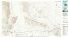
Van Horn
1 : 100000
Van Horn
1 : 100000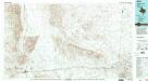
Van Horn
1 : 100000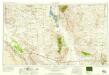
Van Horn
1 : 250000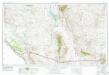
Van Horn
1 : 250000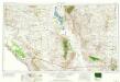
Van Horn
1 : 250000
District of New Mexico
1 : 1200000 Morrison, Charles Clifford 184.-1894 Fort Leavenworth : [éditeur inconnu]
Chihuahua.
1 : 1950000 Garcia Cubas, Antonio, 1832-1912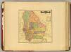
Chihuahua.
1 : 2000000 Garcia Cubas, Antonio, 1832-1912
New Mexico.
1 : 2300000 Cram, George Franklin; Davis, Ellis Arthur
New Mexico.
1 : 3000000 Holdredge, Sterling M.

