Maps of West Bradford Township

Unionville
1 : 24000
Unionville
1 : 24000
Unionville
1 : 24000
Unionville
1 : 24000
Unionville
1 : 24000
Unionville
1 : 24000
West Chester
1 : 62500
West Chester
1 : 62500
West Chester
1 : 62500
West Chester
1 : 62500
West Chester
1 : 62500
West Chester
1 : 62500
West Chester
1 : 62500
West Chester
1 : 62500
West Chester
1 : 62500
West Chester
1 : 62500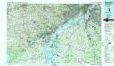
Wilmington
1 : 100000
Fac-simile of a portion of Holme's map of the Province of Pennsylvania : with names of original purchasers from William Penn 1681
Holme, Thomas, d. 1695 L. H. Everts & co.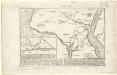
Plan der landung der Gebrüdere Howe, bey dem ausfluss des Elk Strom ...Lords Cornwallis
Will, Johann Martin Will, Johann Martin
A mapp of ye improved part of Pensilvania in America, divided into countyes, townships, and lotts / surveyed by Tho. Holme.
from Whole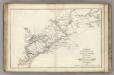
Armees Americaine et Britannique en 1776 et 1777 dans le Maryland.
1 : 450000 Marshall, John
Wilmington
1 : 250000
Wilmington
1 : 250000
Wilmington
1 : 250000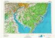
Wilmington
1 : 250000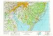
Wilmington
1 : 250000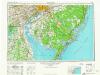
Wilmington
1 : 250000
Wilmington
1 : 250000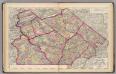
Chester, Dauphin, Berks, Lebanon, York, Lancaster counties.
1 : 300000 Gray, Ormando Willis; Walling, H. F.

