Maps of Paupack Township

Hawley
1 : 24000
Hawley
1 : 24000
Hawley
1 : 24000
Hawley
1 : 24000
Hawley
1 : 24000
Hawley
1 : 62500
Hawley
1 : 62500
Hawley
1 : 62500
Hawley
1 : 62500
Hawley
1 : 62500
Pocono
1 : 125000
Scranton
1 : 100000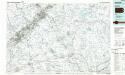
Scranton
1 : 100000
Wayne, Pike counties.
1 : 300000 Gray, Ormando Willis; Walling, H. F.
Scranton
1 : 250000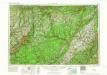
Scranton
1 : 250000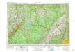
Scranton
1 : 250000
Scranton
1 : 250000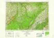
Scranton
1 : 250000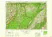
Scranton
1 : 250000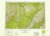
Scranton
1 : 250000
Scranton
1 : 250000
Map of the county of Ulster / by David H. Burr ; engd. by Rawdon, Clark & Co., Albany, & Rawdon, Wright & Co., New York.
from An atlas of the state of New York : containing a map of the state and of the several counties / by David H. Burr.
Map no. II : [to accompany A bill in the chancery of New Jersey, at the suit of John, Earl of Stair ... against Benjamin Bond].
from A bill in the chancery of New-Jersey, at the suit of John earl of Stair, and others, proprietors of the eastern-division of New-Jersey; against Benjamin Bond. and some other persons of Elizabeth-Town, distinguished by the name of the Clinker lot right men. With three large maps, done from copper-plates. To which is added; the publications of the Council of proprietors of East New-Jersey, and Mr. Nevill's speeches to the General assembly, concerning the riots committed in New-Jersey, and the pretences of the rioters, and their seducers. These papers will give a better light into the history and constitution of New-Jersey, than any thing hitherto published, the matters whereof have been chiefly collected from records. Published by subscription:
Map of the city and county of New York.
From Manhattan
Nova Svecia, eller the Swenska Revier [now Delaware River] in India Occicentalis
from Delaware
New York.
1 : 614000 Hammond, C.S.
A New and accurate map of the province of Pennsylvania in North America, from the best authorities.
from Whole Hinton, John,
Province de New-York : en 4 feuilles / par Montrésor.
from (A-Z)

