Maps of Blue Ridge

Cluster Springs
1 : 24000
Cluster Springs
1 : 24000
Cluster Springs
1 : 24000
South Boston
1 : 62500
South Boston
1 : 62500
South Boston
1 : 62500
South Boston
1 : 62500
South Boston
1 : 62500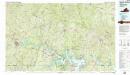
South Boston
1 : 100000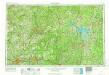
Greensboro
1 : 250000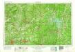
Greensboro
1 : 250000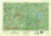
Greensboro
1 : 250000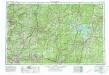
Greensboro
1 : 250000
North-Carolina.
Scott, Joseph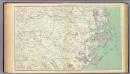
Gen. map III.
1 : 633600 United States. War Department
North Carolina With Part Of Virginia & South Carolina.
1 : 506880 Colton, J. H.
War telegram marking map
1 : 490000 L. Prang & Co Lith. of J. Bien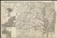
Strategic war points of the United States

A new and accurate map of North Carolina in North America
1 : 1147000
Prang's Naval Expedition Maps: North Carolina coast line
Prang's Naval Expedition Maps: North Carolina coast line L. Prang & Co.
Map Of The Seat Of War.
1 : 633600 Monk, Jacob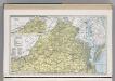
Virginia.
1 : 1271000 Hammond, C.S.
One Hundred & Fifty Miles Around Richmond.
1 : 887040 Magnus, Charles
Map Of North And South Carolina With Their Indian Frontiers. (Northern Section)
1 : 530000 Jefferys, Thomas
Shell Highway Map of Delaware - Maryland, Virginia, W. Virginia. (western portion).
1 : 950400 Shell Oil Company
State of North Carolina.
1 : 1300000 Winterbotham, W.
Map of the most Inhabited part of Virginia containing ... Maryland. (Southern Section)
1 : 650000 Jefferys, Thomas
Carte de la Virginie et du Maryland dressée sur la grande carte angloise de Mrs. Josué Fry et Pierre Jefferson, / par le Sr. Robert de Vaugondy, géographe; Groux.
from John H. Levine Collection Robert de Vaugondy; Mrs. Josué Fry et Pierre Jefferson,


