Maps of Narbonne
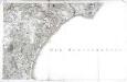
[Narbonne]
1 Blatt : 56 x 89 cm Dupain-Triel; Bourgoin s.n.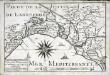
Capitainerie garde coste de Narbonne et partie de celle d'Agde
1 Karte : 22 x 33 cm de Fer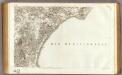
58 Narbonne.
1 : 86400 Cassini family; Cassini, Cesar-Francois, 1714-1784
Govverneme[n]t de Narbonne
1 Karte : Kupferdruck ; 11 x 15 cm Sebastian Cramoisy
Gowernement de Laucatte
1 Karte : Kupferdruck ; 11 x 15 cm Sebastian Cramoisy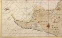
Baija de Agde in Langedoc bij Narbona
France Gerard van Keulen
Carte du diocese de Narbonne
1 Karte : Kupferdruck ; 38 x 45 cm, Bildgrösse 46 x 61 cm Lafont; L'Isle chéz G. Del'Isle sur le quai de l'Horloge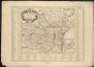
Carte du Diocese de Narbonne
1 : 220000
Le canal royal de Languedoc, pour la ionction de l'ocean et de la mer Mediterranée, 3
1 Blatt : 63 x 50 cm Nolin
Afteekening van de reede Dagde of plan du molle Dagde aen de kust van Provence in de Golf van Narbone in de Middelansche Zee
France Gerard van Keulen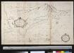
Afteekening van de reede Dagde of plan du molle Dagde aen de kust van Provence in de Golf van Narbone in de Middellansche Zee
France Gerard van Keulen
Govvernement de Pezenas
1 Karte : Kupferdruck ; 11 x 15 cm Sebastian Cramoisy
Lavcatte
1 Plan : Kupferdruck ; 11 x 15 cm Sebastian Cramoisy
Gallia Narbonens. [Karte], in: Theatrum orbis terrarum, S. 89.
1 Karte aus Atlas Ortelius, Abraham
Partie occidentale du Languedoc
1 Karte : Kupferdruck ; 11 x 15 cm Sebastian Cramoisy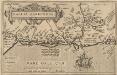
Gallia Narbonens. [Karte], in: Theatrum orbis terrarum, S. 146.
1 Karte aus Atlas Ortelius, Abraham Vrients, Jan Baptista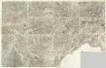
Composite 15: Carte de France.
1 : 86400 Cassini family; Cassini, Cesar-Francois, 1714-1784
Mittelmeer
1 : 150000 Francie Reichs-Marine-Amt
Carte du diocese de Narbonne
1 Karte : Kupferdruck ; 37 x 44 cm, Bildgrösse 45 x 59 cm Lafont; L'Isle chez J. Cóvens et C. Mortier geographes
40) XI.S.E. ''Montpellier'', uit: Carte géologique de France
1 : 500000 Annotatie: Voor aanwezige bladen zie bladoverzicht [S.l : s.n.]
[Languedoc]
Languedoc (Francie) Valk, Gerhard G. Valk
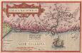
Galliae Narbonensis ora maritima recenter descripta
1 Karte : Kupferdruck ; 29 x 21 cm Ortelius s.n.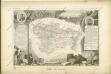

Département de l'Herault
1 Karte : Kupferdruck ; 48 x 53 cm Houdan; Dumez chez Dumez directeur de l'Atlas national rue de la Harpe no. 26, et au dépôt de cet atlas placé au cabinet bibliograph. rue de la Monnoye no. 5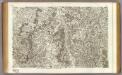
51 Gannat, St. Pourcain.
1 : 86400 Cassini family; Cassini, Cesar-Francois, 1714-1784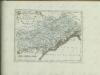

Département de l'Aude
1 Karte : Kupferdruck ; 34 x 41 cm Capitaine s.n.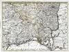
Partie des Sevennes, et le bas Vivarais, le diocese de Monpelliers, et de Nismes [et]c
1 Karte : Kupferdruck ; 42 x 57 cm chez I. Cóvens et C. Mortier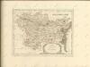
![[Narbonne]](http://biblio.unibe.ch/web-apps/maps/zoomify.php?pic=Ryh_2305_18.jpg&col=ryh)

