Maps of Scarborough

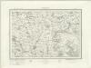
Dvcatvs Eboracensis pars borealis
1 Karte : Kupferdruck ; 37 x 48 cm Blaeu Joan Blaeu
Ducatus Eboracensis Pars Borealis = The Northridinge of Yorkshire
1 : 250000 [Amstelodami] : [apud Joannem Janssonium]
DVCATVS | EBORACENSIS | PARS BOREALIS | THE NORTHRIDING | OF YORK SHIRE.
[Amsterdam : Joan Blaeu]
Ducatus Eboracensis Pars Borealis The Northriding Of York Shire. [Karte], in: Le théâtre du monde, ou, Nouvel atlas contenant les chartes et descriptions de tous les païs de la terre, Bd. 4, S. 394.
1 Karte aus Atlas Blaeu, Willem Janszoon und Blaeu, Joan Blaeu, Willem Janszoon
Ducatus Eboracensis Pars Borealis The Northriding Of York Shire. [Karte], in: Theatrum orbis terrarum, sive, Atlas novus, Bd. 4, S. 458.
1 Karte aus Atlas Blaeu, Joan Blaeu, Willem Janszoon
Ducatus Eboracensis Pars Borealis The Northriding Of York Shire. [Karte], in: Theatrum orbis terrarum, sive, Atlas novus, Bd. 4, S. 458.
1 Karte aus Atlas Blaeu, Joan Blaeu, Willem Janszoon
Ducatus Eboracensis Pars Borealis. The Northridinge of Yorkeshire. [Karte], in: Novus atlas absolutissimus, Bd. 8, S. 43.
1 Karte aus Atlas Janssonius Offizin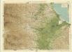
Durham, Sheet 4 - Bartholomew's "Half Inch to the Mile Maps" of England & Wales
1 : 126720 Topographic maps Bartholomew, John George John Bartholomew & Co
York & Scarborough, Sheet 7 - Bartholomew's "Half Inch to the Mile Maps" of England & Wales
1 : 126720 Topographic maps Bartholomew, John George John Bartholomew & Co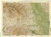
Harrogate, Sheet 6 - Bartholomew's "Half Inch to the Mile Maps" of England & Wales
1 : 126720 Topographic maps Bartholomew, John George John Bartholomew & Co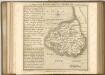

Redcar and Whitby - OS One-Inch Map
1 : 63360 Topographic maps Ordnance Survey Ordnance Survey
Pickering - OS One-Inch Map
1 : 63360 Topographic maps Ordnance Survey Ordnance Survey
Ripon - OS One-Inch Map
1 : 63360 Topographic maps Ordnance Survey Ordnance Survey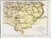
The county palatine of Durham, 4
1 Blatt : 53 x 71 cm R. Sayer & T. Jefferys
Durham - OS One-Inch Map
1 : 63360 Topographic maps Ordnance Survey Ordnance Survey
Harrogate[Map of the county ten miles round] (1832)
Anty. Pickard, Benjn. Jackson Junr. and Geo. Kemp the Proprietors.
Wensleydale - OS One-Inch Map
1 : 63360 Topographic maps Ordnance Survey Ordnance Survey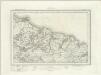
Guisborough (Outline) - OS One-Inch Revised New Series
1 : 63360 Topographic maps Ordnance Survey Ordnance Survey
Guisborough (Hills) - OS One-Inch Revised New Series
1 : 63360 Topographic maps Ordnance Survey Ordnance Survey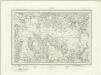
Egton (Outline) - OS One-Inch Revised New Series
1 : 63360 Topographic maps Ordnance Survey Ordnance Survey
Egton (Hills) - OS One-Inch Revised New Series
1 : 63360 Topographic maps Ordnance Survey Ordnance Survey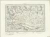
Pickering (Outline) - OS One-Inch Revised New Series
1 : 63360 Topographic maps Ordnance Survey Ordnance Survey
Pickering (Hills) - OS One-Inch Revised New Series
1 : 63360 Topographic maps Ordnance Survey Ordnance Survey
York (Hills) - OS One-Inch Revised New Series
1 : 63360 Topographic maps Ordnance Survey Ordnance Survey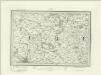
York (Outline) - OS One-Inch Revised New Series
1 : 63360 Topographic maps Ordnance Survey Ordnance Survey
Stockton on Tees (Hills) - OS One-Inch Revised New Series
1 : 63360 Topographic maps Ordnance Survey Ordnance Survey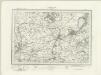
Stockton on Tees (Outline) - OS One-Inch Revised New Series
1 : 63360 Topographic maps Ordnance Survey Ordnance Survey
Northallerton (Hills) - OS One-Inch Revised New Series
1 : 63360 Topographic maps Ordnance Survey Ordnance Survey