Maps of okres Nymburk

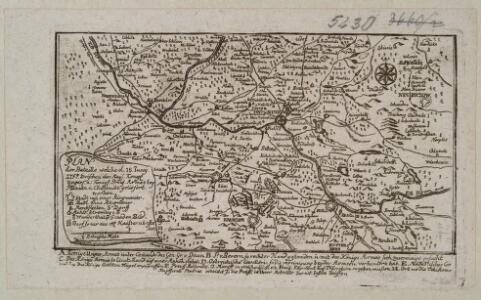
Plan der Bataille welche d. 18. Juny 1757. zwischen der Kays. Königl. Ungar. u. Königl. Preus. Armee bey Planian und Chotemitz geliefert worden

Special - Karte des Koenigreiches Boehmen

Karte der Gemeindegrenzen

187 Prag, uit: Topographische Special-Karte von Deutschland (von Central-Europa) / begründet von D.G. Reymann ; [entworfen und gezeichn. von Heinrich Berghaus... [et al.]]
1 : 200000 Annotatie: Lit.: Daniel Gottlob Reymann und die "Topographische Special-Karte von Deutschland" / von Wolfgang Scharfe, in: Kartographische Nachrichten, 39 (1989), Heft I, p. 1-10; Handgeschreven titel: Reymann's Deutschland : 24 Sectionen: Jena, Penig, Dresden, Zittau, Hirschberg, Breslau, Brieg, Andernach, Coblenz, Giessen, Fulda, Schleusingen, Plauen, Zwickau, Teplitz, Jung Bunzlau, Hohenelbe, Glatz, Neisse, Simmern, Prag, Luxemburg, Birkenfeld; Aanwezig: 23 bladen Reymann, Daniel Gottlob; Berghaus, Heinrich [Berlin : 2. Departement des Kriegsministeriums, Bureau für Plan- und Kartenzeichnung]
Prag
1 : 200000 Praha-oblast (Česko) Fils Brose, Heinrich
Umgebungen von Brandeis und Neu Kolin
1 : 144000 Brandýs nad Labem (Česko) Lang, A.
II. vojenské mapování 14
1 : 144000
Generální mapa okresního hejtmanství Poděbradského
1 : 220000 Poděbrady-oblast (Česko) Wagner, Jan Eduard F. Kytka
Neu-Kolin.
from Spezialkarte der osterreichisch-ungarischen Monarchie.
Okres poděbradský
1 : 100000 Poděbrady-oblast (Česko) Myška, Josef Mapový ateliér Ed. Fastra
Podrobná mapa Království českého
1 : 100000 Kolín (Česko : oblast) Srp, Jan Jaroslav Bursík
Vilímkovy místopisné mapy zemí Koruny české
1 : 100000 Kolín (Česko : oblast) Srp, Jan Jos. R. Vilímek
Generální mapa okresního hejtmanství Kolínského
1 : 220000 Kolín-oblast (Česko) Wagner, Jan Eduard Štumper, Karel J. Šváb
Generální mapa okresního hejtmanství Kolínského
1 : 220000 Kolín-oblast (Česko) Wagner, Jan Eduard F. Kytka
Vilímkovy podrobné mapy politických okresů

Generální mapa okresního hejtmanství Českobrodského
1 : 220000 Český Brod-oblast (Česko) Wagner, Jan Eduard F. Kytka
Prag (Bohmen).
from Spezialkarte der osterreichisch-ungarischen Monarchie.
Generální mapa okresního hejtmanství Karlínského
1 : 220000 Karlín (Praha, Česko) Wagner, Jan Eduard Mareš, František F. Kytka
Generální mapa okresního hejtmanství Karlínského
1 : 220000 Karlín (Praha, Česko) Wagner, Jan Eduard F. Kytka
Generální mapa okresního hejtmanství Karlínského
1 : 220000 Karlín (Praha, Česko) Wagner, Jan Eduard F. Kytka
Übungs-Rayon
1 : 144000 Hradec Králové (Česko : oblast)
Soubor přehledných map pro plánování a statistiku: 3954 – Kolín

Indikační skica mapy stabilního katastru pro město Přelouč VI.
1 : 2880
Okresní hejtmanství Karlínské : samosprávný okres: Karlín
1 : 100000
Hejtmanství kolínské
1 : 150000 Kolín-oblast (Česko) Tůma, Josef
Podrobná mapa Království českého
1 : 100000 Praha (Česko : oblast) Srp, Jan Jos. R. Vilímek
Podrobná mapa Království českého
1 : 100000 Praha (Česko : oblast) Srp, Jan Jaroslav Bursík
Juncbunzlau und Liban.
from Spezialkarte der osterreichisch-ungarischen Monarchie.
Milovice a okolí
1 : 75000 Nymburk (Česko : oblast) Vojenský zeměpisný ústav