Maps of Gatineau
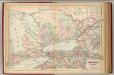
Plan shewing the distribution of the plumbago & phosphate of Lime Rocks : and the position of the most important mining locations in the townships of Buckingham, Portland and Templeton
1 : 88000 Vennor, Henry George 1840-1884 Montréal : The Burland-Desbarats Litho. Compy.
Downtown Ottawa.
Shell Oil Company
Shell Metropolitan Ottawa and Vicinity.
1 : 63360 Shell Oil Company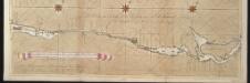
La riviere de Canada ou de St. Laurens de I. de Montreal jusqu'à le lac Ontario aux Nord de l'Amérique
Canada Gerard van Keulen
Survey of the several routes for a rail road from Ogdensburgh to Lake Champlain : made in pursuance of an act of the State of New York, passed May 14th, 1840 / by Edw H. Brodhead, chief engineer ; J.H. Jackson, H. Thomas & V. Whitney, commissrs.
from (A-Z)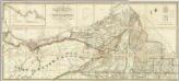
Map of the District Of Montreal, Lower Canada.
1 : 174240 Wyld, James, 1812-1887
Ontario No. 2.
1 : 1110000 Rand McNally and Company
(Canada, Louisiane et Terres Angloises. Southeast section) Le Fleuve Saint-Laurent.
1 : 910000 Anville, Jean Baptiste Bourguignon d, 1697-1782
The provinces of New York, and New Jersey : with part of Pensilvania, and the governments of Trois Rivieres, and Montreal / drawn by Capt. Holland ; engraved by Thomas Jefferys, geographer to His Majesty.
from Parts
The Provinces of New York, and New Jersey; with part of Pensilvania.
1 : 633600 Jefferys, Thomas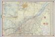
Shell Highway Map of Quebec.
1 : 950400 Shell Oil Company
The provinces of New York, and New Jersey : with part of Pensilvania, and the governments of Trois Rivieres, and Montreal / drawn by Capt. Holland ; engraved by Thomas Jefferys, geographer to His Majesty.
from Parts
Quebec.
1 : 1280000 Asher & Adams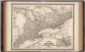
Ontario.
1 : 1350000 Johnson, A.J.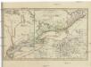
CHARTE Der neuen Niederlassungen in OBER CANADA
Ontario, jezero (New York a Ontario) Smyth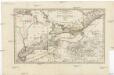
Charte der neuen Niederlassungen in Ober Canada
Ontario, jezero (New York a Ontario) Smyth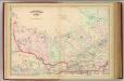
Quebec, part.
1 : 1267200 Asher & Adams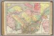
Quebec.
1 : 1204000 Rand McNally and Company
Ontario, Canada.
1 : 1584000 Smith, J. Calvin
Upper Canada.
1 : 2280960 Burr, David H., 1803-1875
Upper Canada.
1 : 1980000 Goodrich, S.G.
Upper Canada.
1 : 1900800 Bradford, Thomas G.
West Part of Canada.
1 : 2250000 Greenleaf, Jeremiah
Upper Canada.
1 : 2250000 Greenleaf, Jeremiah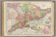
Ontario.
1 : 1140000 Rand McNally and Company
The provinces of New York, and New Jersey; with part of Pensilvania, and the province of Quebec
1 : 700000 drawn by major Holland, surveyor general, of the Northern district in America corrected and improved from the original materials by govern.r Pownall, member of parliament London : printed for Rob.t Sayer & John Bennett [...]
Map of the northern, or, New England states of America, comprehending Vermont, New Hampshire, District of Main, Massachusetts, Rhode Island, and Connecticut

Canada West or Upper Canada.
1 : 1950000 Colton, G.W.
Canada West.
1 : 1850000 Morse, Sidney E. (Sidney Edwards), 1794-1871