Maps of Winterthur
Kyburg, Töss, Illnau-Effretikon (damals Illnau), Schlatt: Staatswaldung: Kyburg, Töss: Bannhalden; Grundriss
Erstellt auf der Basis der im Jahr 1818 von Kaspar Obrist, Forstmeister und Geometer, von Zollikon, durchgeführten Planaufnahme. Hertenstein, Jakob, von Kyburg
Kyburg, Töss, Illnau-Effretikon (damals Illnau), Schlatt: Staatswaldung: Kyburg, Töss: Bannhalden; Grundriss (Nr. 1)
Obrist, Kaspar (1791-1869), Forstmeister und Geometer, von Zollikon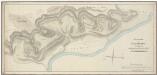
Kyburg, Töss, Illnau-Effretikon (damals Illnau), Schlatt: Staatswaldung: Kyburg, Töss, Illnau-Effretikon (damals Illnau): Bannhalden mit Chämletertobel (Kämleter Tobel), Grossholz, Homelholz (Homelacker Hölzli), Leisacher (Leisacker); Grundriss
Mit handschriftlichen Eintragungen und Einzeichnungen, welche nach der eigentlichen Zeichnung des Plans, d. h. nach 1818, angebracht wurden. Obrist, Kaspar (1791-1869), Forstmeister und Geometer, von Zollikon
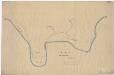
Kyburg: Dem Schloss gehörende Güter; Grundriss
Mit Erläuterungen. Ohne Datumsangabe.
Winterthur, Töss: Von unterhalb der oberen Au bis Tössrain, Tösskorrektion; Situationsplan (Töss-Gebiet Nr. 7, Blatt 4)
1 : 2000 Kilometer 28.560 bis 29.910. Messtischblatt. Ohne Datumsangabe.
Kyburg, Töss, Illnau-Effretikon (damals Illnau), Schlatt: Staatswaldung: Illnau-Effretikon (damals Illnau), Töss: Benneboden, Grossholz, Chämletertobel (Kemleter Tobel), Buchärgeten, Grosswiese, Homelholz (Homelacker), Leisacher (Leissacker); Grundriss (Nr. 20 b)
1 : 2400 Hertenstein, Jakob, Forstmeister des 2. Kreises des Kantons Zürich, von Kyburg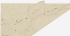
Kyburg, Töss, Illnau-Effretikon (damals Illnau), Schlatt: Staatswaldung: Illnau-Effretikon (damals Illnau): Grossholz, Buchärgeten (Buchärget), Homelholz (Homeläcker Hölzli); Grundriss (Nr. 20 b)
Ohne Datumsangabe. Vermutlich: Obrist, Kaspar (1791-1869), Forstmeister und Geometer, von Zollikon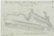
Kyburg, Töss, Illnau-Effretikon (damals Illnau), Schlatt: Staatswaldung: Kyburg: Chämletertobel (Kämmleter Tobel); Grundriss (Nr. 20 a)
Vorderseite: Plan, mit Angabe des Flächeninhalts; Rückseite: Beschreibung. Obrist, Kaspar (1791-1869), Forstmeister und Geometer, von Zollikon
Kyburg, Töss, Winterthur: Von unterhalb der oberen Au bis zur mittleren Au, Tösskorrektion; Situationsplan (Töss-Gebiet Nr. 20, Blatt 10)
1 : 1000 Kilometer 28.625 bis 29.700. Messtischblatt. Aufnahme: Stadelmann, G.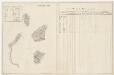
Töss: Dem Amt Winterthur gehörende Waldung (Waldbezirke Homelholz, Homelackerholz, Grossholz, Ober Niesenberg und Haldenholz); Grundrisse (XIV. Planche)
Mit Verzeichnissen der Beschaffenheit der Waldung bei der Visitation 1795 sowie der jährlichen Holzabgabe und Anpflanzung 1795-1819. Aufnahme: Bosshard, Heinrich, andere Schreibweisen: Bosshardt, Bossart, (1748-1815), Bauer und Geometer, von Rümikon Zeichnung: Diezinger, Rudolf (1770-1847), Geometer, von Wädenswil, in Wädenswil
Kyburg, Winterthur: Von Sennschür bzw. Ganser bis unterhalb der oberen Au, Tösskorrektion; Situationsplan (Töss-Gebiet Nr. 20, Blatt 9)
1 : 1000 Kilometer 27.730 bis 28.640. Messtischblatt. Sieber, A.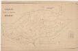
Kyburg, Töss, Illnau-Effretikon (damals Illnau), Schlatt: Staatswaldung: Kyburg, Töss, Illnau-Effretikon (damals Illnau): Chämleten (Kämleten) mit Benneboden, Brandrütitobel, Chämleterwald, (Kämleter Wald), Weieracher (Weyeracker), Bannhalden, Leisacher (Leisäcker), Aspholz; Grundriss
1 : 2000 Mit Verzeichnis der Flächeninhalte. Aufnahme: Kantonales Technikum Winterthur, Geometerschule, in Winterthur Abnahme: Stambach, J. J., Ingenieur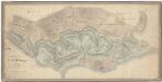
Kyburg, Töss, Illnau-Effretikon (damals Illnau), Schlatt: Staatswaldung: Kyburg: Bennenbodenholz, Chämletertobel (Kemmleter Tobel), Buchärgetenholz, Grossholz, Homelholz, Leissacherholz, Aspholz, Bannhaldenholz, Weieracher (Weyeracker); Grundriss
Mit handschriftlichen Eintragungen und Einzeichnungen, welche nach der eigentlichen Zeichnung des Plans, insbesondere im Rahmen der Revision im Jahr 1916, angebracht wurden. Hertenstein, Jakob, Forstmeister des 2. Kreises des Kantons Zürich, von Kyburg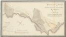
Kyburg, Töss, Illnau-Effretikon (damals Illnau), Schlatt: Staatswaldung: Kyburg, Töss, Illnau-Effretikon (damals Illnau): Grossholz, Buchärgeten, Homelholz (Homelacher), Leisacher (Leissacker), Aspholz (Aspholzli); Grundriss
Teilweise erstellt auf der Basis der im Jahr 1817 von Kaspar Obrist, Forstmeister und Geometer, von Zollikon, durchgeführten Planaufnahme. Mit Verzeichnis der Flächeninhalte. Mit handschriftlichen Eintragungen und Einzeichnungen, welche nach der eigentlichen Zeichnung des Plans, d. h. nach 1823, angebracht wurden. Auftraggebung: Oberforstamt Aufnahme: Hertenstein, Jakob, von Kyburg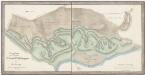
Kyburg, Töss, Illnau-Effretikon (damals Illnau), Schlatt: Staatswaldung: Illnau-Effretikon (damals Illnau), Kyburg, Töss: Bennenbodenholz, Grossholz, Bannhaldenholz, Chämletertobel (Kemleter Tobel), Buchärgetenholz, Homelholz, Leisacherholz (Leissacker Holz), Asphölzli, Weyeracker; Grundriss
Mit handschriftlichen Eintragungen und Einzeichnungen, welche nach der eigentlichen Zeichnung des Plans, d. h. nach 1836, mit Graphitstift angebracht wurden. Hertenstein, Jakob, Forstmeister des 2. Kreises des Kantons Zürich, von Kyburg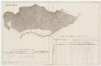
Kyburg: Dem Amt Winterthur gehörende Schlosswaldung (Waldbezirk Bannhalden); Grundriss (XXI. Planche)
Mit Verzeichnissen der Beschaffenheit der Waldung bei der Visitation 1796 sowie der jährlichen Holzabgabe 1796-1819. Diezinger, Rudolf (1770-1847), Geometer, von Wädenswil, in Wädenswil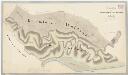
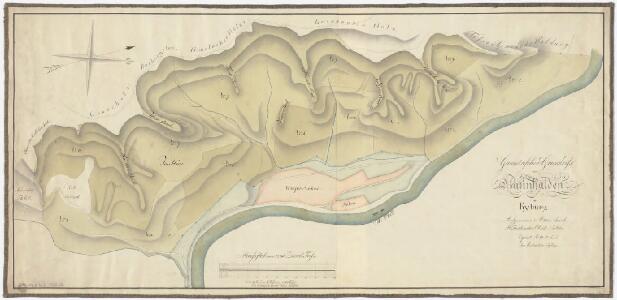
Kyburg, Töss, Illnau-Effretikon (damals Illnau), Schlatt: Staatswaldung: Illnau, Kyburg, Töss: Chämleterwald (Kämmleterwaldung), Bannhalden; Grundriss
Hertenstein, Wilhelm Friedrich (1825-1888), Forstmeister des 2. Kreises des Kantons Zürich, von Kyburg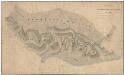
Kyburg, Töss, Illnau-Effretikon (damals Illnau), Schlatt: Staatswaldung: Kyburg: Chämleterwald (Kämmleter Waldung), Bannhalden, Bennenboden, Buchägerten, Homel, Leisacher (Leissacker), Aspholz, Chämletertobel (Kämmleter Tobel), Im Riet, Weieracher (Weyeracker); Grundriss
Mit handschriftlichen Eintragungen und Einzeichnungen, welche nach der eigentlichen Zeichnung des Plans, d. h. nach 1856, angebracht wurden. Hertenstein, Wilhelm Friedrich (1825-1888), bzw. Forstmeister des 2. Kreises des Kantons Zürich, von Kyburg
Kyburg, Töss, Illnau-Effretikon (damals Illnau), Schlatt: Staatswaldung: Kyburg, Illnau-Effretikon (damals Illnau), Töss: Chämleterwald (Kämmleten), Bannhalden, Schlosshalden; Grundriss
1 : 2400 Erstellt auf der Basis der im Jahr 1856 von Friedrich Hertenstein, Forstmeister des 2. Kreises des Kantons Zürich, von Kyburg, durchgeführten Planaufnahme. Reinacher, Forstadjunkt
Kyburg: Staatswaldungen Aspholz, Im Leisacker, Homel, Bennenboden, In der Bannhalde, Kämletertobel, Zimmermannstobel, Ahornboden, Espi (Espiberg), Müllitobel, Weidtobel, Schlosshalden, Tössacker; Grundriss
1 : 5000 Erstellt auf der Basis der am Ende des 19. Jahrhunderts von der Geometerschule des kantonalen Technikums Winterthur verfertigten und im Jahr 1940 von E. Angst und W. Hirzel revidierten Pläne sowie des im Jahr 1919 erstellten Grundbuchplans 2. Mit Verzeichnis der Flächeninhalte. Aeschbach, W.
Kyburg, Töss, Illnau-Effretikon (damals Illnau), Schlatt: Staatswaldung: Kyburg, Töss, Illnau-Effretikon (damals Illnau): Tössacher, Stoffelweg, Sennschür, Espiberg, Weidtobel, Mülitobel (Müllitobel), Ahornboden, Zimmermannstobel, Bännenboden (Bennenboden), Chämleten (Kemleten), Homel, Leisacher, Bannhalden; Grundriss (Blatt 2)
1 : 5000 Kopie eines im Juli 1917 von H. Sch. verfertigten Originalplans. Ohne Erstellungsdatumsangabe.
Kyburg, Töss, Illnau-Effretikon (damals Illnau), Schlatt: Staatswaldung: Kyburg, Töss, Illnau-Effretikon (damals Illnau): Tössacher, Stoffelweg, Sennschür, Espiberg, Weidtobel, Mülitobel (Müllitobel), Ahornboden, Zimmermannstobel, Bännenboden (Bennenboden), Chämleten (Kemleten), Homel, Leisacher, Bannhalden; Grundriss (Blatt 2)
1 : 5000 Kopie eines im Juli 1917 von H. Sch. verfertigten Originalplans. Ohne Erstellungsdatumsangabe. Mit nachträglich angebrachten Eintragungen und farbigen Einzeichnungen.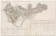
Kyburg: Dem Amt Winterthur gehörende Schlosswaldung (Waldbezirke Kuhhalden, Schlosshalden, Mühletobel, Staudenholz und Zimmermannstobel); Grundriss (XX. Planche)
Mit Verzeichnissen der Beschaffenheit der Waldung bei der Visitation 1796 sowie der jährlichen Holzabgabe und Anpflanzung 1796-1819. Diezinger, Rudolf (1770-1847), Geometer, von Wädenswil, in Wädenswil
Kyburg, Töss, Illnau-Effretikon (damals Illnau), Schlatt: Staatswaldung: Kyburg, Töss, Illnau-Effretikon (damals Illnau): Chämleten (Kämleten) mit Benneboden, Brandrütitobel, Chämleterwald, (Kämleter Wald), Weieracher (Weyeracker), Bannhalden, Leisacher (Leisäcker), Aspholz; Grundriss
1 : 5000 Kantonales Technikum Winterthur, Geometerschule, in Winterthur
Kyburg: Staatswaldungen Zimmermannstobel, Ahornboden, Espi (Espiberg), Mülitobel (Mühletobel), Weidtobel (Waidtobel), Brandrüti, Unter dem Staffelweg, Sennschür (Sennscheuer), Maregg (Marseck), Tössackerrain; Grundriss
1 : 5000 Erstellt auf der Basis der in den Jahren 1896 bis 1897 von der Geometerschule des kantonalen Technikums Winterthur durchgeführten Planaufnahmen. Kantonales Technikum Winterthur, Geometerschule, in Winterthur; Nicod, L.
Kyburg, Töss, Illnau-Effretikon (damals Illnau), Schlatt: Staatswaldung: Kyburg: Tössacher, Tössackerrein, Maregg, Sännschür (Sennscheuer), Unter dem Stoffelweg, Brandrüti, Mülitobel (Mühletobel), Weidtobel, Espiberg, Ahornboden, Zimmermannstobel; Grundriss
1 : 5000 Aufnahme: Kantonales Technikum Winterthur, Geometerschule, in Winterthur Zeichnung: Künzli, Otto Abnahme: Stambach, J. J., Ingenieur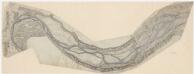
Kyburg, Winterthur, Töss: Töss von Sennschür bis oberhalb der Einmündung der Kempt; Situationsplan (Töss-Gebiet Nr. 8 b bzw. 2. Blatt)
1 : 2000 Hegner, Salomon (1789-1869), Ingenieur, von Winterthur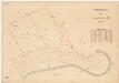
Winterthur, Lindau: Gemeindewaldungen: Winterthur: Burgstal, Langenriemen (Im langen Riemen), Hinterer Tössrain; Grundriss
1 : 2000 Mit Verzeichnis der Flächeninhalte. Ausgangsplan: Grundbuchplan 106 der Gemeinde Winterthur.