Maps of Winterthur
Töss: Gemeinde- und Genossenschaftswaldungen: Am Fusse der Bannhalde gelegene, von der Tösskorrektion betroffene Waldungen; Grundriss
1 : 2400 Erstellt auf der Basis von Plänen der Tösskorrektion. Zeichnung: Hartmann, Karl, Forstadjunkt im Zürcher Oberforstamt, von Aarau, in Unterstrass
Töss: Gemeinde- und Genossenschaftswaldungen: Gemeindewaldungen Bannhalden, Bretscherrain, Riet, früheres Tössbett, Meisholz, Hinterweid, Im Hau, Im hinteren Nägelseeholz, Im vorderen Nägelseeholz; Grundrisse (Tab. I)
Mit Verzeichnis der Flächeninhalte. Mit handschriftlichen Eintragungen und Einzeichnungen, welche nach der eigentlichen Zeichnung des Plans, d. h. nach 1841, mit Tinte und Grafitstift angebracht wurden. Aufnahme und Zeichnung: Hertenstein, Jakob, Forstmeister des 2. Kreises des Kantons Zürich, von Kyburg
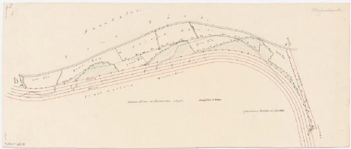
Winterthur, Töss: Von Tössrain bis zur Einmündung der Kempt, Tösskorrektion; Situationsplan (Töss-Gebiet Nr. 7, Blatt 5)
1 : 2000 Kilometer 29.740 bis 31.100. Messtischblatt. Ohne Datumsangabe.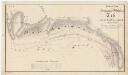
Töss: Gemeinde- und Genossenschaftswaldungen: Gemeindewaldungen Bannhalden, Bretscherrain, Riet; Grundriss (Tab. I)
1 : 2400 Auftraggebung: Forstkommission Aufnahme und Zeichnung: Hertenstein, Jakob, Forstmeister des 2. Kreises des Kantons Zürich, von Kyburg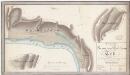
Töss: Gemeinde- und Genossenschaftswaldungen: Gemeindewaldungen Bannhalden, Bretscherrain, Riet, früheres Tössbett, Meisholz, Hinterweid; Grundrisse (Tab. I)
1 : 2400 Mit Verzeichnis der Flächeninhalte. Mit handschriftlichen Eintragungen und Einzeichnungen, welche nach der eigentlichen Zeichnung des Plans, d. h. nach 1841, mit schwarzer und roter Tinte und Grafitstift angebracht wurden. Auftraggebung: Forstkommission Aufnahme und Zeichnung: Hertenstein, Jakob, Forstmeister des 2. Kreises des Kantons Zürich, von Kyburg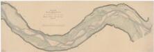
Winterthur: Töss von unterhalb der oberen Au bis zur Einmündung der Kempt; Situationsplan (Töss-Gebiet Nr. 21 b bzw. II. Blatt)
1 : 1000 Kilometer 28.250 bis 31.100. Aufnahme: Wimmersberger, Jakob (1815-1860), Ingenieur, von Wülflingen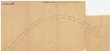
Töss: Töss oberhalb der Einmündung der Kempt; Situationsplan (Töss-No. 113)
1 : 1000 Kilometer 30.340 bis 31.140.
Töss, Winterthur: Von der unteren Au bis oberhalb des Exerzierplatzes, Tösskorrektion; Situationsplan (Töss-Gebiet Nr. 22, Blatt 1)
1 : 1000 Kilometer 29.920 bis 30.460. Messtischblatt. Mit Angabe der Namen der Grundeigentümer. Aufnahme: Stadelmann, G.
Töss, Winterthur: Von oberhalb des Exerzierplatzes bis zur Einmündung der Kempt, Tösskorrektion; Situationsplan (Töss-Gebiet Nr. 22, Blatt 2)
1 : 1000 Kilometer 30.450 bis 31.100. Messtischblatt. Mit Angabe der Namen der Grundeigentümer. Aufnahme: Stadelmann, G.
Töss: Töss beim Kiesplatz in der Bannhalde; Situationsplan (Töss IV)
1 : 1000 Kopie eines früheren Originalplans unbekannter Autorschaft. Mit Originalvermerk: Verfügung vom 16. Sept. 1912 No. 1716. Kopie: Nyffeler, A.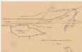
Töss: Gemeinde- und Genossenschaftswaldungen: Genossenschaftswaldungen Bretscherrain, Rossberg; Grundriss
1 : 1000 Erstellt auf der Basis der Eisenbahn-Katasterpläne. Zeichnung: Hartmann, Karl, Forstadjunkt im Zürcher Oberforstamt, von Aarau, in Unterstrass
Töss: Kempt bei der Einmündung in die Töss, Steg über die Kempt; Situationsplan, Grundriss, Längsschnitt, Querschnitt und Detail (Tösszuflüsse linkes Ufer, Nr. 10 b)
1 : 1000 Kilometer 10.450. Mit Berechnungen. Zeichnung: Boxler, H.
Töss: Kempt bei der Einmündung in die Töss, Steg über die Kempt; Längsschnitt, Grundriss, Querschnitt, Situationsplan und Details
1 : 1000 Zeichnung: Boxler, H.
Töss: Kempt bei der Einmündung in die Töss, Steg über die Kempt; Grundriss und Ansichten (Tösszuflüsse linkes Ufer, Nr. 10 a)
1 : 100 Enthält original Bleistiftvermerk: Nicht ausgeführt. Schmid, Rudolf, Geometer und Wasserbau-Assistent im Tiefbauamt des Kantons Zürich, von Zürich, in Zürich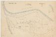
Töss: Bannhalden (In der Bannalde), Leisacher (Im Leisacker); Grundriss
1 : 2000 Mit Verzeichnis der Flächeninhalte. Ausgangsplan: Grundbuchplan 2 der Gemeinde Töss. Sutter, J., Ingenieurbüro und Bauunternehmung, in Zürich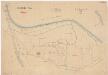
Kyburg, Töss, Illnau-Effretikon (damals Illnau), Schlatt: Staatswaldung: Töss: Aspholz, Bannhalden (In der Bannhalde), Im Leisacher; Grundriss
1 : 2000 Ohne Erstellungsdatumsangabe. Mit Verzeichnis der Flächeninhalte. Ausgangsplan: Grundbuchplan 2 der Gemeinde Töss. Sutter, J., Ingenieurbüro und Bauunternehmung, in Zürich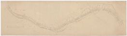
Töss, Winterthur: Von Bannhalden bis zur Einmündung der Kempt, Tösskorrektion; Situationsplan (Töss-Gebiet Nr. 42 e)
1 : 1000 Kilometer 283800 bis 30.090. Mit Angabe der Namen der Grundeigentümer.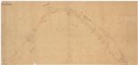
Töss: Töss von oberhalb Tössrain bis zur Brücke der Schweizerischen Nordostbahn NOB und der Schweizerischen Nordbahn SNB; Situationsplan (Töss-No. 130)
1 : 1000 Kilometer 29.616 bis 32.094. Ohne Datumsangabe.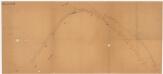
Töss: Töss von oberhalb Tössrain bis zur Brücke der Schweizerischen Nordostbahn NOB und der Schweizerischen Nordbahn SNB; Situationsplan (Töss-No. 129)
1 : 1000 Kilometer 29.616 bis 32.094. Ohne Datumsangabe.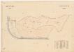
Winterthur, Lindau: Gemeindewaldungen: Winterthur: Hangentobel, Holgass (Hohlgasse), Langenberg, Vorderer Tössrain; Grundriss
1 : 2000 Mit Verzeichnis der Flächeninhalte. Ausgangsplan: Grundbuchplan 107 der Gemeinde Winterthur.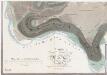
Winterthur, Oberwinterthur, Wülflingen, Turbenthal: Stadtwaldung Winterthur: Südlicher Teil: Tössrain, Flöhrain, Holgass (Hahlgass), Hangentobel, Langenriemen, Burgstal, Chalberweid; Grundriss (Tab. II)
1 : 3000 Erstellt auf der Basis der in den Jahren 1835 und 1836 von Jakob Melchior Ziegler (1801-1883), Kartograf, durchgeführten Planaufnahme. Zeichnung: Hertenstein, Wilhelm Friedrich (1825-1888), Forstadjunkt im Zürcher Oberforstamt, von Kyburg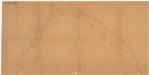
Töss: Töss von oberhalb Tössrain bis zur Brücke der Schweizerischen Nordostbahn NOB und der Schweizerischen Nordbahn SNB; Situationsplan (Töss-No. 131)
1 : 1000 Kilometer 29.616 bis 32.094. Ohne Datumsangabe.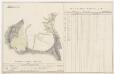
Töss: Dem Amt Winterthur gehörende Waldung (Waldbezirke Leisackerholz, Asphölzli, Bügli, Kollgrub, Im Winkel und Scheitshölzli); Grundrisse (XII. Planche)
Mit Verzeichnissen der Beschaffenheit der Waldung bei der Visitation 1795 sowie der jährlichen Holzabgabe und Anpflanzung 1795-1819. Diezinger, Rudolf (1770-1847), Geometer, von Wädenswil, in Wädenswil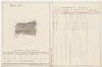
Töss: Dem Amt Winterthur gehörende Waldung (Waldbezirk Maisholz); Grundriss (XI. Planche)
Mit Verzeichnissen der Beschaffenheit der Waldung bei der Visitation 1795 sowie der jährlichen Holzabgabe und Anpflanzung 1795-1819. Aufnahme: Fehr, Johannes, andere Schreibweise: Feer, (1763-1823), Ingenieur und Astronom, von Zürich Zeichnung: Diezinger, Rudolf (1770-1847), Geometer, von Wädenswil, in Wädenswil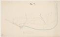
Winterthur, Töss: Töss von Untere Au bis zur Brücke der Schweizerischen Nordostbahn NOB und der Schweizerischen Nordbahn SNB, projektierter Kanal am Tössrain; Situationsplan (II. Blatt)
1 : 2000 Kilometer 26.26 bis 29.000. Mit Originalvermerk: Regierungsbeschluss 19. Wintermt. 1864. Ohne Datumsangabe.
Kyburg, Töss, Illnau-Effretikon (damals Illnau), Schlatt: Staatswaldung: Töss: Bügliholz; Grundriss (Nr. 22 a)
Mit handschriftlichen Eintragungen, welche nach der eigentlichen Zeichnung des Plans, d. h. nach den Jahren 1856 und 1857, mit Grafitstift angebracht wurden. Hertenstein, Wilhelm Friedrich (1825-1888), Forstmeister des 2. Kreises des Kantons Zürich, von Kyburg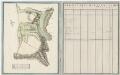
Töss: Dem Amt Töss gehörendes Lehen zu Rossberg; Grundriss und Tabelle (Tab. I)
Lehenmänner: Jacob Schenkel, Vater und Sohn. Mit Angabe der Namen, Grössen und Qualität der einzelnen Güter. Ohne Datumsangabe.
Töss, Winterthur: Von oberhalb der Einmündung der Töss bis zur Brücke bei der Bodmermühle (später Wespimühle), projektierte Tösskorrektion; Situationsplan (Töss-Gebiet Nr. 8 c bzw. 3. Blatt)
1 : 2000 Hegner, Salomon (1789-1869), Ingenieur, von Winterthur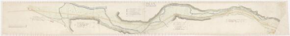
Töss: Strasse von der Bleike (Bleiche) in Kemptthal über Kemptwis bis zu den Christenwiesen beim Tösssteig; Situationsplan
Mit Angabe der Namen von Grundeigentümern.