Maps of Winterthur

Winterthur, Oberwinterthur, Wülflingen, Turbenthal: Stadtwaldung Winterthur: Winterthur: Eschenberg; Übersichtsplan
1 : 12000 Mit Legende der verwendeten Zeichen. Mit Verzeichnis der Flächeninhalte und der Art des Baumbestandes. Aufnahme: Ziegler, Jakob Melchior (1801-1883), Kartograf Stich und Druck: Joh. Wurster und Comp., in Winterthur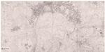
Winterthur: Südlicher Teil der Gemeinde; Übersichtsplan (Schweizerische Grundbuchvermessung)
1 : 5000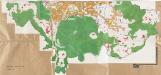
Winterthur: Südlicher Teil der Definition der Siedlungen für die eidgenössische Volkszählung am 01.12.1960; Siedlungskarte Nr. 102 b
1 : 5000 Auf Ausgangskarte angebrachte farbige Einzeichnungen und Eintragungen. Ohne Erstellungsdatumsangabe.
Winterthur, Oberwinterthur, Wülflingen, Turbenthal: Stadtwaldung Winterthur: Winterthur: Eschenberg; Übersichtsplan
1 : 12000 Mit Legende der verwendeten Zeichen. Mit Verzeichnis der Flächeninhalte und der Art des Baumbestandes. Aufnahme: Ziegler, Jakob Melchior (1801-1883), Kartograf Stich und Druck: Joh. Wurster und Comp., in Winterthur
Plan der Stadtwaldung Eschenberg
1 : 10000 1 Karte fortgeführt durch das Städt. Kataster Bureau
Plan des Waldes Eschenberg
1 : 12000 1 Karte aufgenommen u. gez. v. J.M. Ziegler 1835 ; reduzirt u. gest. in der topogr. Anstalt v. J. Wurster u. Comp.
[Stadtplan von Winterthur]
1 : 25000 1 Plan
Winterthur mit der umliegenden Gegend Ao. 1292
1 : 15000 1 Karte
Winterthur, Oberwinterthur, Wülflingen, Turbenthal: Stadtwaldung Winterthur: Winterthur: Eschenberg; Übersichtsplan
1 : 9000 Mit Legende der verwendeten Zeichen. Mit Verzeichnis der Flächeninhalte und der Art des Baumbestandes. Aufnahme und Zeichnung: Ziegler, Jakob Melchior (1801-1883), Kartograf Verkleinerung und Steingravur: Wurster, Johann Ulrich (1814-1880) Lithografie: Studer, C.
Winterthur, Oberwinterthur, Wülflingen, Turbenthal: Stadtwaldung Winterthur: Winterthur: Eschenberg; Übersichtsplan
1 : 9000 Mit Legende der verwendeten Zeichen und Farben. Mit Verzeichnis der Flächeninhalte und der Art des Baumbestandes. Aufnahme und Zeichnung: Ziegler, Jakob Melchior (1801-1883), Kartograf Verkleinerung und Steingravur: Wurster, Johann Ulrich (1814-1880) Lithografie: Studer, C.
Winterthur, Oberwinterthur, Wülflingen, Turbenthal: Stadtwaldung Winterthur: Winterthur: Eschenberg; Übersichtsplan
1 : 9000 Mit Legende der verwendeten Zeichen. Mit Verzeichnis der Flächeninhalte und der Art des Baumbestandes. Aufnahme und Zeichnung: Ziegler, Jakob Melchior (1801-1883), Kartograf Verkleinerung und Steingravur: Wurster, Johann Ulrich (1814-1880) Lithografie: Studer, C.
Winterthur, Oberwinterthur, Wülflingen, Turbenthal: Stadtwaldung Winterthur: Winterthur: Eschenberg; Übersichtsplan
1 : 9000 Mit Legende der verwendeten Zeichen. Mit Verzeichnis der Flächeninhalte und der Art des Baumbestandes. Aufnahme und Zeichnung: Ziegler, Jakob Melchior (1801-1883), Kartograf Verkleinerung und Steingravur: Wurster, Johann Ulrich (1814-1880) Lithografie: Studer, C.
Situations-Plan des Waldes Eschenberg
1 : 9000 1 Karte aufgenommen & gezeichnet von J.M. Ziegler ; reducirt & auf Stein gravirt von Joh. Wurster 1837 ; Lith. v. C. Studer
Situations-Plan des Waldes Eschenberg & Bestandes-Karte für 1836
1 : 9000 1 Karte aufgenommen & gezeichnet von J.M. Ziegler ; reducirt & auf Stein gravirt von Joh. Wurster 1837 ; Lith. v. C. Studer
Situations-Plan des Waldes Eschenberg & Bestandes-Karte für 1936
1 : 9000 1 Karte aufgenommen & gezeichnet von J.M. Ziegler ; reducirt & auf Stein gravirt von Joh. Wurster 1837 ; Lith. v. C. Studer
Winterthur: Einteilung der Stadtwaldungen im Revier I-IV (Eschenberg); Übersichtsplan
1 : 10000 Ohne Erstellungsdatumsangabe. Joh. Wurster und Comp., in Winterthur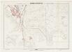
Winterthur: Definition der Siedlungen für die eidgenössische Volkszählung am 01.12.1970; Siedlungskarten: Teilkarte VII
1 : 5000 Auf Ausgangskarte angebrachte farbige Einzeichnungen und Eintragungen. Mit Legende. Ohne Erstellungsdatumsangabe. Ausgangskarte: Übersichtsplan (Schweizerische Grundbuchvermessung) der Gemeinde Winterthur. Ausgangskarte: Vermessungsbüro der Stadt Winterthur
Winterthur, Oberwinterthur, Wülflingen, Turbenthal: Stadtwaldung Winterthur: Winterthur: Eschenberg; Übersichtsplan
1 : 5000
Plan der Stadtwaldung Eschenberg
1 : 10000 1 Karte hrsg. von der Topographischen Anstalt Winterthur
Plan der Stadtwaldung Eschenberg
1 : 10000 Topographische Anstalt Winterthur J. Schlumpf Topogr. Anstalt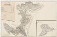
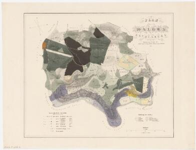
Kyburg: Dem Amt Winterthur gehörende Schlosswaldung (zehn Waldbezirke); Grundrisse (XV. Planche)
Mit Verzeichnis der Namen und Flächeninhalte der zehn Waldbezirke. Aufnahme: Hotz, Heinrich (1768-1813), Forstmeister des Kantons Zürich, von Oberrieden Zeichnung: Hirzel, Hans Caspar (1756-1841), Ober- bzw. Kantonsforstinspektor, von Zürich
Winterthur, Oberwinterthur, Wülflingen, Turbenthal: Stadtwaldung Winterthur: Winterthur: Eschenberg; Übersichtsplan
Mit Verzeichnis der Flächeninhalte. Keller, H., von Eglisau
Winterthur, Oberwinterthur, Wülflingen, Turbenthal: Stadtwaldung Winterthur: Winterthur: Eschenberg; Übersichtsplan
1 : 10000 Mit Legende der verwendeten Zeichen. Wurster, Randegger und Cie., in Winterthur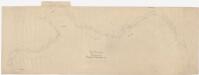
Kyburg, Seen, Töss: Von oberhalb der gedeckten Brücke in Kyburg bis zur Brücke der Schweizerischen Nordostbahn NOB oberhalb Töss, Tösskorrektion; Situationsplan (Töss-Gebiet Nr. 40 m)
1 : 2000 Kilometer 25.971 bis 32.118. Mit Originalvermerk: Nach dem Hochwasser v. 11-13 Juni 1876.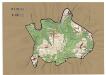
Kyburg: Definition der Siedlungen für die eidgenössische Volkszählung am 01.12.1950; Siedlungskarte
1 : 10000 Auf Ausgangskarte angebrachte farbige Einzeichnungen und Eintragungen. Ohne Erstellungsdatumsangabe.
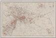
[Winterthur]
1 : 25000 1 Plan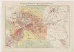
Winterthur, Oberwinterthur, Seen, Töss, Veltheim: Stadtgemeinde und umliegende Gemeinden; Übersichtsplan
1 : 10000 Beilage zu den Vorschriften für die Bebauung der äusseren Quartiere der Stadtgemeinde. Kartographia Winterthur AG, in Winterthur
Elsau, Oberwinterthur, Seen: Manöverfeld östlich von Winterthur mit Lagerplätzen; Grundriss
1 : 10000 Mit Erläuterungen zu den für tauglich befundenen Lagerplätzen entlang des Mattenbachs und der Eulach sowie zum "Manövrierfeld". Biedermann, Leutnant
Vorlagen für die Topographische Karte des Kantons Zürich (Wild-Karte): Pausen mit Gewässern, Eisenbahn, Strassen: Originalblatt XI: Sektion Kyburg
1 : 25000