Maps of Glattfelden
Glattfelden: Glatt von den Hundigwiesen oberhalb Glattfelden bis zur Einmündung in den Rhein; Situationsplan (Glatt-Gebiet Nr. 40)
1 : 5000 Nach dem Hochwasser vom 10.-12.06.1876. Aufnahme: Pfister, K.
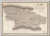
Glattfelden: Gemeinde; Ortsplan
1 : 5000 Mit Legende.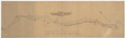
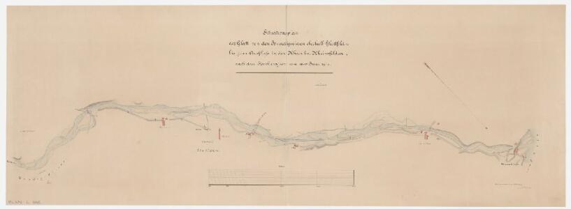
Glattfelden: Glatt von den Hundigwiesen oberhalb Glattfelden bis zur Einmündung in den Rhein; Situationsplan
1 : 5000 Nach dem Hochwasser vom 10.-12.06.1876. Vermutlich: Pfister, K.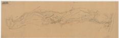
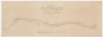
Glattfelden: Glatt von den Eglisauerwiesen bis zur Einmündung in den Rhein; Situationsplan
1 : 5000 Handgezeichnete Kopie eines Plans der Nordost-Bahn (NOB). Mit Flurnamen und Höhenkurven. Ohne Datumsangabe.
Glattfelden: Definition der Siedlungen für die eidgenössische Volkszählung am 01.12.1970; Siedlungskarte
1 : 5000 Auf Ausgangskarte angebrachte farbige Einzeichnungen und Eintragungen. Mit Legende. Ohne Erstellungsdatumsangabe. Ausgangskarte: Übersichtsplan (Schweizerische Grundbuchvermessung) der Gemeinde Glattfelden. Vermutlich: S., R. Ausgangskarte: Meliorations- und Vermessungsamt des Kantons Zürich Ausgangskarte fotomechanische Reproduktion und Druck: Ed. Aerni-Leuch, in Bern
Glattfelden: Gemeinde; Übersichtsplan (Schweizerische Grundbuchvermessung)
1 : 5000 Fotomechanische Reproduktion und Druck: Ed. Aerni-Leuch, in Bern
Glattfelden: Gemeinde; Übersichtsplan (Schweizerische Grundbuchvermessung)
1 : 5000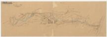
Glattfelden: Eglisauermatte bis zur Einmündung in den Rhein, Glattkorrektion; Situationsplan
1 : 5000 Projektvariante 1. Mit Flurnamen, Höhenkurven sowie Korrektionsachse ab dem Wehr Ryffel. Ohne Datumsangabe.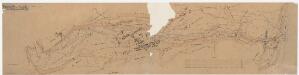
Glattfelden: Eglisauermatte bis zur Einmündung in den Rhein, Glattkorrektion; Situationsplan
1 : 5000 Projektvariante 2. Mit Flurnamen, Höhenkurven sowie Korrektionsachse ab dem Wehr Ryffel. Ohne Datumsangabe.
Glattfelden: Gemeinde; Übersichtsplan (Schweizerische Grundbuchvermessung)
1 : 5000
Glattfelden: Gemeinde; Übersichtsplan (Schweizerische Grundbuchvermessung)
1 : 5000
Glattfelden: Gemeinde; Übersichtsplan (Schweizerische Grundbuchvermessung)
1 : 5000 Mit Legende.
Glattfelden: Zehntenbezirke Glattfelden und Schachen, zehntenpflichtig dem Bischof von Konstanz; Grundriss
1 : 2250 Mit Verzeichnis der Flächeninhalte. Dänniker, Joh. Heinrich
Vorlagen für die Topographische Karte des Kantons Zürich (Wild-Karte): Bezirk Dielsdorf: Kartenbild-Pausen für Grenzen: Stadel und Glattfelden
Enderli, Heinrich (1830-1902), Zeichner, von Wipkingen (gemäss Angabe von Alfred Oberli in seinem Aufsatz in Cartographica Helvetica, Bd. 1-2 (1990): Die Wild-Karte des Kantons Zürich 1852-1868, S. 31)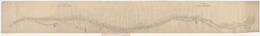
Glattfelden: Glatt vom Spinnereiwehr oberhalb Glattfelden bis zur Einmündung in den Rhein; Situationsplan
1 : 1000 Kilometer 31.960 bis 35.710. Mit Eigentümerangaben und Legende. Vermutlich: Nussbaumer, K., andere Schreibweise: C., Geometer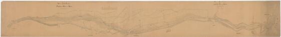
Glattfelden: Oberhalb des Wehrs der Spinnerei Ryffel in Glattfelden bis zur Einmündung in den Rhein, Glattkorrektion, alter Glattlauf; Situationsplan
1 : 1000 Kilometer 31.860 bis 35.760. Mit Eigentümerangaben. Mit Originalvermerk: Reg. Beschluss vom 26. Jenner 1878. Wetli, Kaspar, andere Schreibweise: Wethli, (1822-1889), Kantonsingenieur, von Männedorf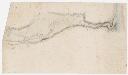
Glattfelden: Glatt, Blatt 5: Glattfelden bis zur Einmündung in den Rhein; Situationsplan-Entwurf (Glatt 3)
1 : 6000 Ohne Datumsangabe. Frei, J. J.
Glattfelden: Zehntenbezirk Zweidlen, zehntenpflichtig der Herrschaft Eglisau: Generalplan; Grundriss
1 : 4860 Ohne Datumsangabe. Fehr, Johannes, andere Schreibweise: Feer, (1763-1823), Ingenieur und Astronom, von Zürich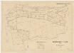
Glattfelden: Gemeindewaldung: Gemeindewaldungen im südwestlichen Teil der Gemeinde; Grundriss
1 : 2000 Mit Verzeichnis der Flächeninhalte. Ausgangsplan: Grundbuchplan 9 der Gemeinde Glattfelden. Meier, Robert, Grundbuchgeometer, in Glattfelden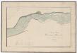
Glattfelden: Hundigwiesen bis mittlere Wiesen, Glattlauf, Korrektion von 1813; Situationsplan
1 : 400 Ohne Datumsangabe. Breitinger, David (1763-1834), Feinmechaniker und Zeugherr, von Zürich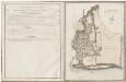
Glattfelden: Zehntenbezirk Zweidlen, zehntenpflichtig der Herrschaft Eglisau: Tab. I: Nördlicher Teil; Grundriss und tabellarische Beschreibung
1 : 4860 Kopie eines von Johannes Fehr verfertigten Originalplans. Mit Verzeichnis der geografischen Beschreibungen, der Beschaffenheit und der Flächeninhalte der einzelnen Güter. Ohne Datumsangabe. Fehr, Johannes, andere Schreibweise: Feer, (1763-1823), Ingenieur und Astronom, von Zürich
Glattfelden: Zehntenbezirk Zweidlen, zehntenpflichtig der Herrschaft Eglisau: Generalplan; Grundriss
1 : 4860 Kopie eines von Johannes Fehr verfertigten Originalplans. Ohne Datumsangabe. Fehr, Johannes, andere Schreibweise: Feer, (1763-1823), Ingenieur und Astronom, von Zürich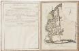
Glattfelden: Zehntenbezirk Zweidlen, zehntenpflichtig der Herrschaft Eglisau: Tab. I: Nördlicher Teil; Grundriss und tabellarische Beschreibung
1 : 2240 Mit Verzeichnis der geografischen Beschreibungen, der Beschaffenheit und der Flächeninhalte der einzelnen Güter. Ohne Datumsangabe. Fehr, Johannes, andere Schreibweise: Feer, (1763-1823), Ingenieur und Astronom, von Zürich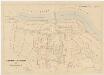
Glattfelden: Gemeindewaldung: Gemeindewaldungen im nordwestlichen Teil der Gemeinde sowie beim Zweidler Graben; Grundrisse
1 : 2000 Mit Verzeichnis der Flächeninhalte. Ausgangsplan: Grundbuchplan 6 der Gemeinde Glattfelden. Meier, Robert, Grundbuchgeometer, in Glattfelden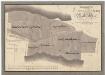
Glattfelden: Gemeindewaldung: Üsserhau (Äusserer Hau), Hinterhau, Chüestellihau (Kühstellehau), Sigristenhau, Lenibuck (Lehmenbuckhau), Chatzenstig (Katzensteighau), Franzenhau; Grundriss
1 : 2400 Mit Verzeichnis der Flächeninhalte. Mit handschriftlichen Eintragungen und Einzeichnungen, welche nach der eigentlichen Zeichnung des Plans, d. h. nach 1847, mit roter und schwarzer Tinte und Grafitstift angebracht wurden. Auftraggebung: Forstkommission Aufnahme und Zeichnung: Meister, Hans Ulrich (1801-1874), Forstmeister des 3. Kreises des Kantons Zürich, von Benken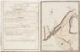
Glattfelden: Zehntenbezirk Zweidlen, zehntenpflichtig der Herrschaft Eglisau: Tab. II: Südöstlicher Teil; Grundriss und tabellarische Beschreibung
1 : 2240 Kopie eines von Johannes Fehr verfertigten Originalplans. Mit Verzeichnis der geografischen Beschreibungen, der Beschaffenheit und der Flächeninhalte der einzelnen Güter. Ohne Datumsangabe. Fehr, Johannes, andere Schreibweise: Feer, (1763-1823), Ingenieur und Astronom, von Zürich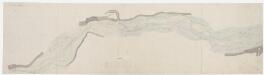
Glattfelden: Brunnenwiese bis unterhalb der Staatsbrücke, Glattkorrektion; Grundriss (Glatt Nr. 4)
1 : 2000 Ohne Datumsangabe.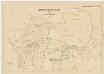
Glattfelden: Gemeindewaldung: Gemeindewaldungen im nordöstlichen Teil der Gemeinde sowie beim Oberschwendli (Oberes Schwendli); Grundrisse
1 : 2000 Mit Verzeichnis der Flächeninhalte. Ausgangsplan: Grundbuchplan 4 der Gemeinde Glattfelden. Meier, Robert, Grundbuchgeometer, in Glattfelden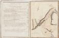
Glattfelden: Zehntenbezirk Zweidlen, zehntenpflichtig der Herrschaft Eglisau: Tab. II: Südöstlicher Teil; Grundriss und tabellarische Beschreibung
1 : 2240 Mit Verzeichnis der geografischen Beschreibungen, der Beschaffenheit und der Flächeninhalte der einzelnen Güter. Ohne Datumsangabe. Fehr, Johannes, andere Schreibweise: Feer, (1763-1823), Ingenieur und Astronom, von Zürich