Maps of Adliswil
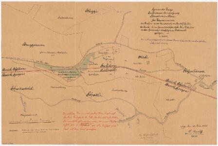
Adliswil, Stallikon, Enge: Beim Albis, Expropriationen für Quellwasserbeschaffung in der Enge; Situationsplan
1 : 2000 Erstellt auf der Basis eines Plans über die Staatswaldung Schattli. Mit Originalvermerk: Reg. Beschluss v. 26. Septb. 1885. Mit Angabe der Namen von Grundeigentümern. Unmuth, A., Gemeindeingenieur von Enge
Stallikon, Adliswil, Aeugst am Albis, Langnau am Albis: Staatswaldung Buechenegg: Stallikon, Adliswil: Fülimatt, Bruggenmoos, Husacher, Vorder Buechenegg, Näfenhüser, Müsli; Grundriss
1 : 2000
Stallikon, Adliswil, Aeugst am Albis, Langnau am Albis: Staatswaldung Buechenegg: Stallikon, Adliswil, Aeugst am Albis: Staatswaldung Buechenegg; Grundriss (Blatt 2)
1 : 2000
Stallikon, Adliswil, Aeugst am Albis, Langnau am Albis: Staatswaldung Buechenegg: Stallikon, Adliswil: Projektierte Strassen durch die Waldungen Bliggi, Rifen, Näfenhüser; Grundriss
1 : 1000 Ohne Erstellungsdatumsangabe. Aufnahme und Zeichnung: Kramer, Gottlieb, Forstmeister des 1. Kreises des Kantons Zürich, von Berg am Irchel
Stallikon, Adliswil, Aeugst am Albis, Langnau am Albis: Staatswaldung Buechenegg: Stallikon: Landabtausch im Müsli mit Otto Huber, im Näfenhaus; Grundriss
1 : 2000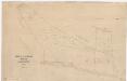
Stallikon, Adliswil, Aeugst am Albis, Langnau am Albis: Staatswaldung Buechenegg: Adliswil, Stallikon: Joh. Huber gehörende Privatwaldung im Näfenhüser; Grundriss
1 : 1000 Zeichnung: Naef, Paul, Forstadjunkt im Zürcher Oberforstamt, von Zürich, in Zürich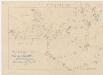
Stallikon, Adliswil, Aeugst am Albis, Langnau am Albis: Staatswaldung Buechenegg: Adliswil: Weier, Schattli; Grundriss (Nr. 2)
1 : 1000 Aufnahme und Zeichnung: Honegger, Huldreich, Forstadjunkt im Zürcher Oberforstamt, von Zürich, in Zürich
Stallikon, Adliswil, Aeugst am Albis, Langnau am Albis: Staatswaldung Buechenegg: Adliswil, Stallikon, Aeugst am Albis, Langnau am Albis: Pflanzgarten in der Staatswaldung Buechenegg; Grundriss
1 : 500
Stallikon, Adliswil, Aeugst am Albis, Langnau am Albis: Staatswaldung Buechenegg: Adliswil: Waldung zwischen Hermen und Löchli; Situationsplan
1 : 5000 Zeichnung: J. Meyer, Ingenieurbüro, Adliswil
Stallikon, Adliswil, Aeugst am Albis, Langnau am Albis: Staatswaldung Buechenegg: Adliswil: Angekaufte Höfe Weier und Schattli; Grundriss (Blatt I)
1 : 2000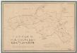
Stallikon, Adliswil, Aeugst am Albis, Langnau am Albis: Staatswaldung Buechenegg: Adliswil: Schattli, Weier; Grundriss
1 : 2000 Polygonometrische und tachymetrische Vermessung. Zeichnung: Honegger, Huldreich, Forstadjunkt im Zürcher Oberforstamt, von Zürich, in Zürich
Stallikon, Adliswil, Aeugst am Albis, Langnau am Albis: Staatswaldung Buechenegg: Stallikon, Adliswil, Aeugst am Albis: Staatswaldung Buechenegg; Grundriss (Blatt 4)
1 : 2000 Ohne Erstellungsdatumsangabe.
Stallikon, Adliswil, Aeugst am Albis, Langnau am Albis: Staatswaldung Buechenegg: Adliswil: Waldungen zwischen Rätzeren und Bruggenmoos; Situationsplan
1 : 2000 J. Meyer, Ingenieurbüro, Adliswil
Stallikon, Adliswil, Aeugst am Albis, Langnau am Albis: Staatswaldung Buechenegg: Stallikon: Auf der Buechenegg befindliche Liegenschaften im Besitz des in der Schipfe in Zürich wohnhaften Herrn Bluntschli; Grundriss
1 : 1000 Mit zwei Verzeichnissen der Flächeninhalte. Mit Angabe der Namen von privaten Grundeigentümern. Mit handschriftlichen Eintragungen und Einzeichnungen, welche nach der eigentlichen Zeichnung des Plans, d. h. nach 1857, mit rotem und grünem Farbstift angebracht wurden. Aufnahme und Zeichnung: Frei, A., Ingenieur
Stallikon, Adliswil, Aeugst am Albis, Langnau am Albis: Staatswaldung Buechenegg: Stallikon, Adliswil, Aeugst am Albis: Rifen, Näfenhüser, Stüpfer, Müsli, Grossholz, Bruggenmoos; Grundriss
1 : 5000 Ohne Datumsangabe. Aufnahme: Keller, Heinrich, Forstmeister des 2. Kreises des Kantons Zürich, von Truttikon, in Veltheim; Kramer, Gottlieb, Forstmeister des 1. Kreises des Kantons Zürich, von Berg am Irchel; Fierz, Werner, Forstadjunkt im Zürcher Oberforstamt, von Herrliberg, in Zürich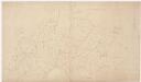
Stallikon, Adliswil, Aeugst am Albis, Langnau am Albis: Staatswaldung Buechenegg: Stallikon, Adliswil, Aeugst am Albis: Stüpfer, Bliggi, Schattli; Grundriss
1 : 2000 Ohne Datumsangabe.
Stallikon, Adliswil, Aeugst am Albis, Langnau am Albis: Staatswaldung Buechenegg: Adliswil, Stallikon, Aeugst am Albis, Langnau am Albis: Buechenegg; Übersichtsplan
1 : 5000 Mit Verzeichnis der Flächeninhalte aller elf Abteilungen.
Stallikon, Adliswil, Aeugst am Albis, Langnau am Albis: Staatswaldung Buechenegg: Adliswil, Stallikon, Aeugst am Albis, Langnau am Albis: Staatwaldung Buechenegg; Übersichtsplan
1 : 5000 Mit Verzeichnis der Flächeninhalte aller zwölf Abteilungen sowie Angabe der Beschaffenheit und des Alters des Baumbestands. Bayer, P., Fortsingenieur
Stallikon, Adliswil, Aeugst am Albis, Langnau am Albis: Staatswaldung Buechenegg: Stallikon, Adliswil, Aeugst am Albis: Stüpfer, Forchbüel, Schattli; polygonometrisches Netz
1 : 5000 Aufnahme und Zeichnung: Honegger, Huldreich, Forstadjunkt im Zürcher Oberforstamt, von Zürich, in Zürich
Stallikon, Adliswil, Aeugst am Albis, Langnau am Albis: Staatswaldung Buechenegg: Adliswil, Stallikon, Aeugst am Albis, Langnau am Albis: Staatwaldung Buechenegg; Übersichtsplan
1 : 5000 Mit Verzeichnis der Flächeninhalte aller zwölf Abteilungen sowie Angabe der Beschaffenheit und des Alters des Baumbestands. Bayer, P., Fortsingenieur
Stallikon, Adliswil, Aeugst am Albis, Langnau am Albis: Staatswaldung Buechenegg: Stallikon, Adliswil: Hinter Buechenegg, Rifen, Näfenhüser, Müsli, Bliggi, Grossholz, Bruggenmoos; Luftaufnahme
Ohne Erstellungsdatumsangabe. Eidgenössische Landestopographie, in Köniz-Wabern
Stallikon, Adliswil, Aeugst am Albis, Langnau am Albis: Staatswaldung Buechenegg: Adliswil, Stallikon, Aeugst am Albis, Langnau am Albis: Wasserversorgungsnetz der Stadt Zürich in der Staatswaldung Buechenegg; Grundriss
1 : 5000 Projektverfasser: Steiner, W., Forstingenieur; Kindhauser, J.
Stallikon, Adliswil, Aeugst am Albis, Langnau am Albis: Staatswaldung Buechenegg: Adliswil, Stallikon, Aeugst am Albis, Langnau am Albis: Wegnetz in der Staatswaldung Buechenegg; Grundriss
1 : 5000 Projektverfasser: Steiner, W., Forstingenieur; Kindhauser, J.
Stallikon, Adliswil, Aeugst am Albis, Langnau am Albis: Staatswaldung Buechenegg: Adliswil, Stallikon, Aeugst am Albis, Langnau am Albis: Generelles Wegnetz in der Staatswaldung Buechenegg; Grundriss
1 : 5000 Projektverfassung: Kindhauser, J.
Stallikon, Adliswil, Aeugst am Albis, Langnau am Albis: Staatswaldung Buechenegg: Stallikon, Adliswil, Aeugst am Albis, Langnau am Albis: Näfenhüser, Müsli, Bliggi, Grossholz, Bruggenmoos, Sprächerberg, Reifholz; Luftaufnahme
Ohne Erstellungsdatumsangabe. Eidgenössische Landestopographie, in Bern
Stallikon, Adliswil, Aeugst am Albis, Langnau am Albis: Staatswaldung Buechenegg: Stallikon, Adliswil, Aeugst am Albis: Schattli, Weier, Bliggi, Stüpfer; Grundriss, Übersichtsplan
1 : 5000 Mit Verzeichnis der Flächeninhalte.
Stallikon, Adliswil, Aeugst am Albis, Langnau am Albis: Staatswaldung Buechenegg: Stallikon, Adliswil, Aeugst am Albis: Staatswaldung Buechenegg mit Schattli, Weier, Bliggi, Stüpfer; Übersichtsplan
1 : 5000 Mit aufgeklebtem Verzeichnis der Flächeninhalte. Mit handschriftlichen Eintragungen und Einzeichnungen, welche nach der eigentlichen Zeichnung des Plans, d. h. nach ca 1897, mit Tinte angebracht wurden. Zeichnung: Honegger, Huldreich, Forstadjunkt im Zürcher Oberforstamt, von Zürich, in Zürich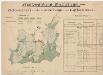
Stallikon, Adliswil, Aeugst am Albis, Langnau am Albis: Staatswaldung Buechenegg: Stallikon, Adliswil, Aeugst am Albis: Erwerbungen und Aufforstungen in den Waldungen Schattli, Weier, Bliggi, Stüpfer; Grundriss
1 : 5000 Mit Verzeichnis der Verkäufer, des Kaufpreises, der Flächeninhalte sowie Angabe der Beschaffenheit der Waldabteilungen. Mit Angabe der Namen der privaten Grundeigentümer. Zeichnung: Honegger, Huldreich, Forstadjunkt im Zürcher Oberforstamt, von Zürich, in Zürich
Adliswil: Definition der Siedlungen für die eidgenössische Volkszählung am 01.12.1970; Siedlungskarte
1 : 5000 Auf Ausgangskarte angebrachte farbige Einzeichnungen und Eintragungen. Mit Legende. Ohne Erstellungsdatumsangabe. Vermutlich: S., R.