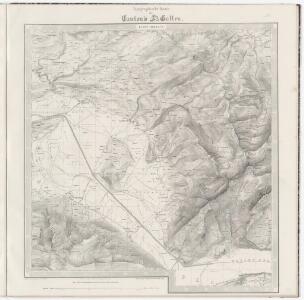
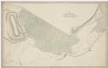
Maps of Schänis

Topographische Karte des Kantons St. Gallen mit Einschluss des Kantons Appenzell (Eschmann-Karte): Blatt Schänis
1 : 25000 Aufnahme: Eschmann, Johannes (1808-1852), Geodät und Mathematiker, von Zürich; Eberle, Joseph Meinrad (1809-1896), Ingenieur Stich: Steiner, P.; Leuzinger, Rudolf (1826-1896), Kartograf und Lithograf, von Netstal GL und Mollis GL; Randegger, Johannes (1830-1900), Kartograf Gebirgszeichnung und Leitung des Stichs: Ziegler, Jakob Melchior (1801-1883), Kartograf Stich und Druck: Joh. Wurster und Comp., in Winterthur
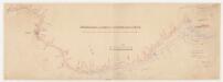
Plan des Ausflusses des Wallen Sees und des Laufs der Linth bis in den Zürich See
1 : 47000 1 Karte gezeichnet von H. Conr. Escher
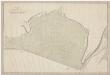
Karte des jetzigen und früheren Zustandes vom untern Linththale
1 : 40000 Legler, Gottlieb Heinrich Schmid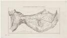
Mollis GL bis Schmerikon SG: Alter und neuer Zustand der Linth; Situationsplan (Zürichsee-Gebiet Nr. 10 b)
1 : 40000 Mit Originalvermerk: Verfügung 30.X.1867. Mit Originalvermerk: Reg. Beschl. 12.IV. 1874. Legler, G. H., Linthingenieur Wurster, Randegger und Cie., in Winterthur
Topographische Karte des Cantons St. Gallen mit Einschluss des Cantons Appenzell
1 : 25000 Blatt 11 Eschmann, Johannes ; Steiner, P. ; Randegger, Johannes ; Ziegler, Jakob Melchior Topographische Anstalt v. Joh. Wurster & Comp.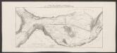
Carte des unteren Linththales und der zu Entsumpfung der Thalebene ausgeführten Canäle
1 : 43200 Pestalozzi, Heinrich ; Goll, Johann Jakob Schmid
Topographische Karte des Cantons St. Gallen mit Einschluss des Cantons Appenzell
1 : 25000 16 Karten aufgenommen von J. Eschmann ... [et al.] ; gestochen von P. Steiner ; Gebirg von J. Randegger ; Gebirgszeichnung u. Leitung des Stiches durch J.M. Ziegler Topographische Anstalt v. Joh. Wurster & Comp., Winterthur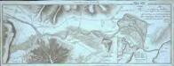
Plan des Ausflusses des Wallensees und des Laufs der Linth bis in den Zürich See
1 Karte : Kupferdruck ; 15 x 41 cm Escher von der Linth s.n.
Weesen SG bis Tuggen SZ: Memoire über die Ableitung des Walensees durch Verbesserung des Abflusses der Weesener Linth bei der Ziegelbrücke: Niederurnen GL bis Tuggen SZ: Lauf der Linth zwischen der Ziegelbrücke und Schloss Grynau samt Situation der umliegenden Gegend; Grundriss
Handgezeichnete Kopie eines im Jahr 1785 von Sigmund Spitteler, Ingenieur, von Läufelfingen BL und von Hottingen, verfertigten Originalplans. Verfassung des Memoires: Hirzel, Hans Caspar (1756-1841), Landschreiber zu Altstetten, Mitglied der Forst- und Waldkommission, von Zürich Kopie des Plans: Hirzel, Hans Caspar (1756-1841), Landschreiber zu Altstetten, Mitglied der Forst- und Waldkommission, von Zürich
Hans Konrad Gyger's Züricher-Cantons-Carte
1 : 32000 Blatt 8 Gyger, Hans Conrad ; Zeller-Werdmüller, Heinrich Hofer & Burger
Grosse Landtafel des Zürcher Gebiets: Blatt 8: Reichenburg und Umgebung
Möglicherweise: Wagner, Johann (1675-1714)
Hans Konrad Gyger's Züricher-Cantons-Carte
1 : 32000 Blatt 7 Gyger, Hans Conrad ; Zeller-Werdmüller, Heinrich Hofer & Burger
Hans Konrad Gyger's Züricher-Cantons-Carte 1667
1 : 32000 1 Karte in 56 Teilen Hans Konrad Gyger
Grosse Landtafel des Zürcher Gebiets: Blatt 7: Uznach und Umgebung
Möglicherweise: Wagner, Johann (1675-1714)
Wesen und Umgebungen
1 : 45000 1 Karte J. Goll del et sc. [Feuerwerker Gesellschaft], [Zürich]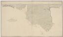
Niederurnen GL bis Benken SG: Linthkanal von der Ziegelbrücke bis zum Giessen, insbesondere sämtliche Güter rechts des Kanals; Grundriss
Benken SG bis Schmerikon SG: Linthkanal vom Giessen bis an den Zürichsee, insbesondere sämtliche Güter rechts des Kanals; Grundriss
Bilten GL bis Schmerikon SG: Grenze zwischen den Kantonen Glarus und Schwyz bis zur Einmündung in den Zürichsee, alte und neue Linth; Situationsplan
1 : 6083 Mit Parzellennummerierung.
Hans Konrad Gyger's Züricher-Cantons-Carte 1667
1 : 32000 1 Karte in 56 Teilen Hans Konrad Gyger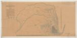
Benken SG, Tuggen, SZ, Uznach SG: Oberhalb Grinau SZ, Linthkorrektion, linkes Ufer; Situationsplan und Polygonzug
1 : 6155 Mit Höhenkurven. Wimmersberger, Jakob (1815-1860), Ingenieur, von Wülflingen Zeichnung: Benz., I.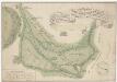
Schübelbach SZ bis Tuggen SZ: Linthgebiet; Situationsplan (Zürichsee-Gebiet Nr. 1)
1 : 8000 Handgezeichnete Kopie eines im Jahr 1759 von Niederöst, Hauptmann, verfertigten Originalplans. Kopie: Albertin, Johann Heinrich (1713-1790), Vermesser, Kartograf und Artilleriehauptmann, von Zürich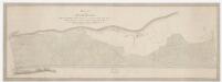
Niederurnen GL, Bilten GL: Linthkanal von der Ziegelbrücke bis zur Grenze zwischen Schwyz und Glarus, insbesondere sämtliche Güter links des Kanals; Grundriss

<<Das>> Schloss Grynau mit der Umgegend
1 : 21000 1 Karte [Feuerwerker-Gesellschaft], [Zürich]
Weesen SG bis Tuggen SZ: Memoire über die Ableitung des Walensees durch Verbesserung des Abflusses der Weesener Linth bei der Ziegelbrücke: Weesen SG, Mollis GL, Oberurnen GL, Niederurnen GL, Schänis SG: Vereinigung der Weesener Linth und der Glarner Linth samt Projekten zur Verhinderung des Aufschwellens des Walensees; Grundriss
Handgezeichnete Kopie eines im Jahr 1785 von Andreas Lanz (1740-1803), Ingenieur, von Rohrbach BE, verfertigten Originalplans. Mit Nivellement. Verfassung des Memoires: Hirzel, Hans Caspar (1756-1841), Landschreiber zu Altstetten, Mitglied der Forst- und Waldkommission, von Zürich Kopie des Plans: Hirzel, Hans Caspar (1756-1841), Landschreiber zu Altstetten, Mitglied der Forst- und Waldkommission, von Zürich
Mollis GL: Molliser Kanal, insbesondere sämtliche angrenzende Güter; Grundriss
Mit Nachträgen zum Plan von ca. 1827. Ohne Datumsangabe.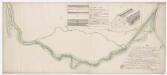
Benken SG, Tuggen SZ: Spettlinth und Rieselgiessen samt projektiertem Damm und Wuhr entlang des Einlaufkanals von der Langen Wuhr bis zum Lignizer Steg; Grundriss und Profile
Ohne Datumsangabe. Spitteler, Sigmund (1732-1818), Ingenieur und Strassenbauinspektor des Kantons Zürich, von Läufelfingen BL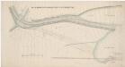
Benken SG bis Schmerikon SG: Oberhalb Grinau SZ bis zur Einmündung in den Zürichsee, alte und korrigierte Linth samt Variante nach Schmerikon; Situationsplan (Zürichsee-Gebiet Nr. 7 a)
1 : 2000 Handgezeichnete Kopie eines von G. H. Legler, Ingenieur der Linthpolizeikommission, verfertigten Originalplans. Kopie: Benz, J.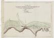
Weesen SG bis Tuggen SZ: Memoire über die Ableitung des Walensees durch Verbesserung des Abflusses der Weesener Linth bei der Ziegelbrücke: Niederurnen GL, Schänis SG: Projektierte Teilung der Glarner Linth von der Weesener Linth bei der Ziegelbrücke; Grundriss
Verfassung des Memoires: Hirzel, Hans Caspar (1756-1841), Landschreiber zu Altstetten, Mitglied der Forst- und Waldkommission, von Zürich Zeichnung des Plans: Städelin, David Anton, andere Schreibweisen: Städeli, Stedelin, (1737-1830), Goldschmied, Ingenieur- bzw. Artilleriehauptmann, Landschaftsvermesser, Ratsherr, Landesfürsprech sowie Richter im Neunergericht, von Schwyz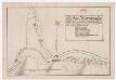
Niederurnen GL: Linth oberhalb und unterhalb der Ziegelbrücke mit Angabe der projektierten Werke; Grundriss
Städelin, David Anton, andere Schreibweisen: Städeli, Stedelin, (1737-1830), Goldschmied, Ingenieur- bzw. Artilleriehauptmann, Landschaftsvermesser, Ratsherr, Landesfürsprech sowie Richter im Neunergericht, von Schwyz