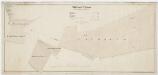
Maps of Bezirk Andelfingen

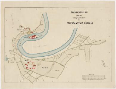
Pflegeanstalt Rheinau: Liegenschaften; Übersichtsplan
1 : 4000 Erstellt auf der Basis der im Jahr 1891 von J. Giezendanner, Ingenieur und Kataster-Verifikator des Kantons Zürich, erstellten Planaufnahmen.
Pflegeanstalt Rheinau: Liegenschaften; Übersichtsplan
1 : 4000 Erstellt auf der Basis der im Jahr 1891 von J. Giezendanner, Ingenieur und Kataster-Verifikator des Kantons Zürich, erstellten Planaufnahmen.
Pflegeanstalt Rheinau: Liegenschaften mit elektrischen Leitungen; Übersichtsplan
1 : 4000 Mit Legende. Ausgangsplan: Übersichtsplan über die Liegenschaften der Pflegeanstalt Rheinau, erstellt auf der Basis der im Jahr 1891 von J. Giezendanner, Ingenieur und Kataster-Verifikator des Kantons Zürich, erstellten Planaufnahmen. Hofer Ausgangsplan: Katasterbüro des Kantons Zürich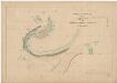
Pflegeanstalt Rheinau: Situationspläne: Liegenschaften der Pflegeanstalt
1 : 4000 Giezendanner, J., Ingenieur und Kataster-Verifikator des Kantons Zürich, von Zürich, in Zürich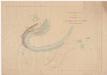
Jestetten (Deutschland), Altenburg (Deutschland), Rheinau: Liegenschaften der Pflegeanstalt Rheinau; Situationsplan
1 : 4000 Ohne Datumsangabe.
Pflegeanstalt Rheinau: Liegenschaften; Übersichtsplan
1 : 4000 Erstellt auf der Basis der in den Jahren 1891-1892 von J. Giezendanner, Ingenieur und Kataster-Verifikator des Kantons Zürich, und H. Landolt, Geometer, erstellten Planaufnahmen. Gebrüder Hoesch
Pflegeanstalt Rheinau: Liegenschaften; Übersichtsplan
1 : 4000 Benz, B.; Benz, Joh., Ingenieur und Kataster-Verifikator des Kantons Zürich, von Schwamendingen und Zürich, in Zürich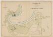
Pflegeanstalt Rheinau: Liegenschaften; Übersichtsplan
1 : 4000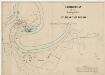
Pflegeanstalt Rheinau: Liegenschaften; Übersichtsplan
1 : 4000 Mit Bleistift-Notizen. Ausgangsplan: Übersichtsplan über die Liegenschaften der Pflegeanstalt Rheinau, erstellt auf der Basis der im Jahr 1891 von J. Giezendanner, Ingenieur und Kataster-Verifikator des Kantons Zürich, erstellten Planaufnahmen. Ausgangskarte: Katasterbüro des Kantons Zürich
Kloster Rheinau: Güter vor dem Oberen Tor; Grundriss
Mit Legende.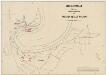
Pflegeanstalt Rheinau: Liegenschaften mit Wasserleitungen; Übersichtsplan
1 : 4000 Ausgangsplan: Übersichtsplan über die Liegenschaften der Pflegeanstalt Rheinau, erstellt auf der Basis der im Jahr 1891 von J. Giezendanner, Ingenieur und Kataster-Verifikator des Kantons Zürich, erstellten Planaufnahmen. Ausgangsplan: Katasterbüro des Kantons Zürich
Pflegeanstalt Rheinau: Wasserversorgungsanlage; Situationsplan IV
1 : 1000 Rohrer, Alb., Nachfolger von C. Weinmann, Ingenieur, Winterthur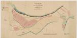
Pflegeanstalt Rheinau: Güter im Rheinauerfeld; Grundriss
1 : 2000 Mit Legende. Benz, Joh., Ingenieur und Kantonsgeometer, von Schwamendingen und Zürich, in Zürich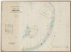
Kloster Rheinau: Waldung in Altenburg (Deutschland); Grundriss
1 : 4000 Mit Legende. Schupp, A., Geometer
Gemeinde Rheinau: Generelles Kanalisationsprojekt mit Kraftwerk; Situationsplan
1 : 2500 Mit Legende. Stauber, M., Ingenieurbüro, Zürich
Gemeinde Rheinau: Städtchen mit Umgebung; Grundriss
1 : 5000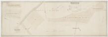
Kloster Rheinau: Güter in Rheinau; Grundriss
1 : 1000 Güter: Franzhausen-, Mühle-, Tugstein-, Schocken-, Spitz- und Breitenwegacker und in Nägelis Halden. Mit Legende. Peter, R., Ingenieur, in Unterstrass
Pflegeanstalt Rheinau: Liegenschaften mit projektierter Kolonie; Grundriss
Mit Legende.
Kloster Rheinau: Waldungen im Schwaben; Grundriss

Pflegeanstalt Rheinau: Verbindung der Wasserleitungen der alten und neuen Anstalt; Grundriss
1 : 4000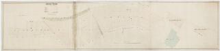
Kloster Rheinau: Güter in Rheinau; Grundriss
1 : 1000 Güter: Eichelhag, Sewerben, Breitenwegbuch, im Boden, Unter und Ober Bergacker und Bergwiese. Mit Legende. Peter, R., Ingenieur, in Unterstrass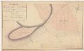
Rheinau: Gemeinde-, Kloster- und Genossenschaftswaldungen: Gemeindewaldungen Seewerben, Eichelhag; Grundriss (Tab. I)
Mit Verzeichnis der Flächeninhalte. Mit handschriftlichen Eintragungen und Einzeichnungen, welche nach der eigentlichen Zeichnung des Plans, d. h. nach 1824, mit Tinte und Grafitstift angebracht wurden. Auftraggebung: Forstkommission Aufnahme und Zeichnung: Meister, Hans Ulrich (1801-1874), Forstmeister des 3. Kreises des Kantons Zürich, von Benken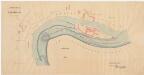
Jestetten (Deutschland), Altenburg (Deutschland), Rheinau: Rhein bei der Landesgrenze; Situationsplan
1 : 1000 Kopie eines Plans über die Wasserwerksanlagen der Stadt Winterthur in Rheinau. Kopie: Benz, Joh., Kantonsgeometer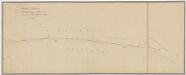
Pflegeanstalt Rheinau: Wasserversorgung Uhwiesen; Situationsplan
1 : 1000
Rheinau: Gemeinde-, Kloster-, Genossenschafts- und Staatswaldungen: Klosterwaldung Bergholz; Grundriss
Mit Angabe des Flächeninhalts. Mit handschriftlichen Eintragungen und Einzeichnungen, welche nach der eigentlichen Zeichnung des Plans, d. h. nach 1824, mit Tinte und Grafitstift angebracht wurden. Aufnahme: Meister, Hans Ulrich (1801-1874), Forstmeister des 3. Kreises des Kantons Zürich, von Benken Zeichnung: Reutemann, R., Geometer, in Rheinau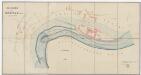
Grenze zwischen dem Kanton Zürich und dem Grossherzogtum Baden bei Rheinau; Grundriss
1 : 1000 Erstellt auf der Grundlage eines Plans über die Wasserwerks-Anlagen der Stadt Winterthur in Rheinau. Mit Legende. Benz, Joh., Ingenieur und Kantonsgeometer, von Schwamendingen und Zürich, in Zürich
Rheinau: Gemeinde-, Kloster-, Genossenschafts- und Staatswaldungen: Klosterwaldung Bergholz; Grundriss
Mit Angabe des Flächeninhalts. Meister, Hans Ulrich (1801-1874), Forstmeister des 3. Kreises des Kantons Zürich, von Benken
Rheinau: Gemeinde-, Kloster-, Genossenschafts- und Staatswaldungen: Klosterwaldung Bergholz; Grundriss
Mit Angabe des Flächeninhalts. Meister, Hans Ulrich (1801-1874), Forstmeister des 3. Kreises des Kantons Zürich, von Benken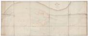
Kloster Rheinau: Grundriss
1 : 500 Auftraggebung: Direktion der öffentlichen Arbeiten Aufnahme und Zeichnung: Peter, R., Geometer, von Unterstrass