Maps of Kilchberg (ZH)
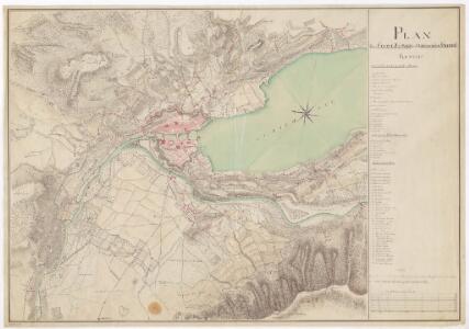
Plan der Stadt Zürich und der umliegenden Gegend von 1802
Vermutlich (handgezeichnete) Kopie eines im Jahr 1802 von C. Hirzel verfertigten Plans, wobei als Basis der von Usteri erstellte Plan diente. Mit Angabe der öffentlichen Gebäude, Brücken, Plätze und Promenaden sowie der Fortifikationswerke. Ohne Erstellungsdatumsangabe.
Übersichtsplan der Stadt Zürich mit den im Rahmen der ersten Eingemeindung von 1893 hinzugekommenen ehemals selbstständigen Gemeinden Aussersihl, Enge-Leimbach, Fluntern, Hirslanden, Hottingen, Oberstrass, Riesbach, Unterstrass, Wiedikon, Wipkingen, Wollishofen
1 : 15000 Mit roter Einzeichnung der Grenzen der neu gebildeten Stadtkreise I (Altstadt), II (Enge, Wollishofen), III (Aussersihl, Wiedikon), IV (Oberstrass, Unterstrass, Wipkingen) und V (Fluntern, Hirslanden, Hottingen, Riesbach). Ohne Datumsangabe. Hofer und Burger, in Zürich
Blatteinteilung für den Übersichtsplan der Stadt Zürich 1 : 2500
1 : 15000 Zeichnung: Vermessungsamt der Stadt Zürich Druck: Hofer und Co., in Zürich
Übersichtsplan der Stadt Zürich und der umliegenden Gemeinden in 23 Blättern: Übersicht der Blätter
1 : 15000 Vermessungsamt der Stadt Zürich Druck: Hofer und Co., in Zürich
Übersichtsplan der Stadt Zürich
1 : 15000 1 Plan
Bebauungsplan für die Stadt Zürich mit den Hauptverkehrslinien
1 : 5000 Mit Angabe der Stadtgrenze, des Baurayons, der bestehenden und projektierten Hauptverkehrslinien sowie der Schiessplätze, des Waldes und der öffentlichen Anlagen. Dieser Plan wurde am 26.05.1900 vom Grossen Stadtrat genehmigt. Tiefbauaumt der Stadt Zürich; Wenner, V., Stadtingenieur
Plan der Stadt Zürich und ihrer Umgebung
1 : 13500 1 Plan [Rudolf] Gross del. ; [Rinaldo] Bressanini sc.
Zürich: Der Stadt gehörende Waldungen auf Stadtgebiet; Übersichtsplan
1 : 30000 Mit Verzeichnis der Namen, der Verwaltungsorgane und der Flächeninhalte der acht Waldkomplexe. Hofer und Co., in Zürich
Übersichtsplan der Stadt Zürich und der Gemeinden Aussersihl, Enge-Leimbach, Fluntern, Hirslanden, Hottingen, Oberstrass, Riesbach, Unterstrass, Wiedikon, Wipkingen, Wollishofen
1 : 15000 1 Plan
Uebersichtsplan der Stadt Zürich
1 : 15000 1 Plan
Übersichtsplan der Stadt Zürich
1 : 15000 1 Plan
Bebauungsplan für die Stadt Zürich mit den Hauptverkehrslinien
1 : 10000 Mit Angabe der Stadtgrenze, des Baurayons, der bestehenden und projektierten Hauptverkehrslinien sowie der Schiessplätze, des Waldes und der öffentlichen Anlagen. Hofer und Co., in Zürich
Übersichtsplan der Stadt Zürich und der Gemeinden Aussersihl, Enge-Leimbach, Fluntern, Hirslanden, Hottingen, Oberstrass, Riesbach, Unterstrass, Wiedikon, Wipkingen, Wollishofen
1 : 15000 Ohne Datumsangabe. Hofer und Burger, in Zürich
Übersichtsplan der Stadt Zürich und der Gemeinden Aussersihl, Enge-Leimbach, Fluntern, Hirslanden, Hottingen, Oberstrass, Riesbach, Unterstrass, Wiedikon, Wipkingen, Wollishofen
1 : 15000 1 Plan
Horgen, Langnau am Albis, Thalwil, Hottingen, Zürich: Staatswaldungen, Genossenschaftswaldungen und Zürcher Stadtwaldungen: Zürich: Bauzonenplan der Stadt Zürich
1 : 25000 Mit Angabe der Grenzen der Stadt und des Baurayons sowie der Baugebiete. Ohne Datumsangabe. Vermutlich: Fietz, Hermann, Kantonsbaumeister, von Männedorf, in Zollikon
Übersichtsplan der Stadt Zürich und der Gemeinden Aussersihl, Enge-Leimbach, Fluntern, Hirslanden, Hottingen, Oberstrass, Riesbach, Unterstrass, Wiedikon, Wipkingen, Wollishofen
1 : 15000 1 Plan
Zwei projektierte Verlegungen der linksufrigen Zürichseebahn auf dem Gebiet der Stadt Zürich; Übersichtsplan
1 : 10000 Ohne Erstellungsdatumsangabe. Ausgangskarte: Lith. Druck und Verlag Hofer und Co., in Zürich
Uebersichtsplan der Stadt Zürich und Umgebung
1 : 5000 Hofer, Johann Jakob Technisches Bureau
Übersichtsplan der Stadt Zürich
1 : 15000 Vermessungsamt der Stadt Zürich Topographische Anstalt J. Schlumpf, in Winterthur
Übersichtsplan der Stadt Zürich
1 : 30000 1 Karte Lith. von Hofer & Burger
Bauzonenplan der Stadt Zürich
1 : 15000 Mit Originalvermerk: Beilage zur Vorlage des Stadtrates vom 22. Juli 1911 betreffend Vorschriften für die offene Bebauung. Mit Angabe der Grenzen der Stadt sowie des bisherigen und des neuen Baurayons, der Baugebiete sowie der festgesetzten und projektierten Hauptverkehrslinien. Ausgangsplan: Bauzonenplan der Stadt Zürich vom Januar 1908. Stadtrat der Stadt Zürich Ausgangsplan: Vermessungsamt der Stadt Zürich; Kartographia Winterthur A.G., in Winterthur
Bauzonenplan der Stadt Zürich
1 : 10000 Mit Angabe der geschlossenen (Zonen 1 bis 2) und offenen (Zonen 3 bis 7) Bebauungen. Vermessungsamt der Stadt Zürich Art. Institut Orell Füssli AG, in Zürich
Übersichtsplan der Stadt Zürich
1 : 10000 Mit Angabe u. a. des öffentlichen Verkehrsnetzes, der Arten von Strassen und Wegen sowie der Beschaffenheit von unbebauten Flächen. Vermessungsamt der Stadt Zürich Art. Institut Orell Füssli AG, in Zürich
Reformierte Kirchgemeinden auf dem Gebiet der Stadt Zürich um 1932; Übersichtsplan
1 : 10000 Mit roter Einzeichnung der Grenzen der reformierten Kirchgemeinden, der Gemeinde-, Kreis- und Quartiergrenzen sowie mit Angabe von Gebäuden, Strassen und Wegen, Linien des öffentlichen Verkehrs sowie unbebauten Flächen. Vermessungsamt der Stadt Zürich Art. Institut Orell Füssli AG, in Zürich
Übersichtsplan der Stadt Zürich
1 : 15000 Mit Angabe der Kreisgrenzen, Eisenbahnlinien und -stationen, Strassenbahn- und Kraftwagenlinien, Einbahnstrassen, Drahtseilbahnen sowie Dampfbootverbindungen. Vermessungsamt der Stadt Zürich Druck: Hofer und Co. AG, in Zürich
Uebersichtsplan der Stadt Zürich
1 : 5000 1 Plan
Uebersichtsplan der Stadt Zürich und Umgebung
1 : 5000 1 Plan nach den neuesten Aufnahmen zusammengestellt durch das Ingenieur-Bureau der Stadt ; Lith. von Hofer & Burger
Uebersichtsplan der Stadt Zürich und Umgebung
1 : 5000 1 Plan nach den neuesten Vermessungen zusammengestellt durch das technische Bureau der Stadt ; lithographirt von J.J. Hofer
[Zürich]
1 : 12000 1 Plan