Maps of Wallisellen

Rieden (später Wallisellen): Gemeindebann; Grundriss
1 : 3000 Kopie eines im Jahr 1730 von Johann Jakob Lavater (1658-1739), Artilleriehauptmann und Feldmesser, von Zürich, verfertigten Originalplans.
Rieden (später Wallisellen): Zehntenbezirk, zehntenpflichtig dem Kornamt; Grundrisse
1 : 3205 Mit Angabe der Beschaffenheit der einzelnen Güter. Lavater, Johann Jakob (1658-1739), Artilleriehauptmann und Feldmesser, von Zürich
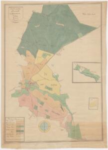
Dietlikon: Gemeinde; Übersichtsplan (Schweizerische Grundbuchvermessung)
1 : 5000
Dietlikon: Gemeinde; Übersichtsplan (Schweizerische Grundbuchvermessung)
1 : 5000 Fotomechanische Reproduktion und Druck: Ed. Aerni-Leuch, in Bern
Dietlikon: Gemeinde; Übersichtsplan (Schweizerische Grundbuchvermessung)
1 : 5000 Fotomechanische Reproduktion und Druck: Ed. Aerni-Leuch, in Bern
Dietlikon: Gemeinde; Übersichtsplan (Schweizerische Grundbuchvermessung)
1 : 5000 Fotomechanische Reproduktion und Druck: E. Collioud und Co., in Bern
Dietlikon: Definition der Siedlungen für die eidgenössische Volkszählung am 01.12.1960; Siedlungskarte Nr. 131
1 : 5000 Auf Ausgangskarte angebrachte farbige Einzeichnungen und Eintragungen. Ohne Erstellungsdatumsangabe.
Dietlikon: Definition der Siedlungen für die eidgenössische Volkszählung am 01.12.1970; Siedlungskarte
1 : 5000 Auf Ausgangskarte angebrachte farbige Einzeichnungen und Eintragungen. Mit Legende. Ohne Erstellungsdatumsangabe. Ausgangskarte: Übersichtsplan (Schweizerische Grundbuchvermessung) der Gemeinde Dietlikon. Ausgangskarte: Meliorations- und Vermessungsamt des Kantons Zürich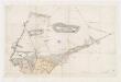
Dietlikon: Dem Spital Zürich gehörende Waldungen namens Dietliker Hardholz und Riedener Gemeinholz; Grundriss
Dietlikon: Gemeindewaldung: Forstbezirke; Übersichtsplan
1 : 5000 Mit Verzeichnis der Flächeninhalte der 14 Waldabteilungen. Aufnahme und Zeichnung: von Orelli, Adolf, Forstassistent im Zürcher Oberforstamt, von Zürich, in Zürich
Dietlikon: Gemeindewaldung: Forstbezirke; Übersichtsplan
1 : 2000 Mit Verzeichnis der Flächeninhalte der 25 Waldabteilungen. Mit handschriftlichen Eintragungen und Einzeichnungen, welche nach der eigentlichen Zeichnung des Plans, d. h. nach 1918, angebracht wurden. Aufnahme und Zeichnung: Stamm, Johann, Grundbuchgeometer, in Bülach
Schwerzenbach: Acker- und Wiesland; Grundriss
Rieden: Strassenkorrektion auf Gemeindegebiet; Situationsplan
Spitteler, Sigmund (1732-1818), Ingenieur und Strassenbauinspektor des Kantons Zürich, von Läufelfingen BL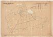
Wallisellen: Gemeinde- und Genossenschaftswaldungen: Waldungen der Gemeinde und der Holzkorporationen Wallisellen und Rieden; Grundriss
1 : 2000 Mit Verzeichnis der Flächeninhalte. Ausgangsplan: Grundbuchplan 28 der Gemeinde Wallisellen. Aufnahme und Zeichnung: Bretscher, R., Grundbuchgeometer
Übersichtsplan der Stadt Zürich in 57 Blättern, Blatt 15: Teil von Schwamendingen bei der Grenze zu Wallisellen und Dübendorf
1 : 2500 Nachführungsstand ca. 1984. Vermessungsamt der Stadt Zürich
Vorlagen für die Topographische Karte des Kantons Zürich (Wild-Karte): Bezirk Bülach: Ortspläne: Rieden, Wallisellen
1 : 10000
Adliswil bis Rümlang: Kanalkataster: Blatt 38: Zürich, bei der Verzweigung der alten Glatt und der Glatt; Situationsplan
1 : 2500 Ohne Datumsangabe. Tiefbauamt der Stadt Zürich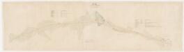
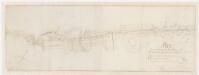
Wallisellen, Dietlikon, Wangen-Brüttisellen (damals Wangen): Strasse von Niederschwerzenbach bzw. Hof bis Brüttisellerried; Situationsplan
1 : 1000 Mit Angabe der Namen von Grundeigentümern.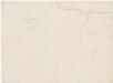
Dübendorf, Wangen-Brüttisellen (damals Wangen), Dietlikon: Riedflächen im Chriesbachgebiet: Blatt II: Dietlikon; Riedflächenplan
1 : 2000 Diezinger, Rudolf (1770-1847), Geometer, von Wädenswil, in Wädenswil
Dietlikon: Gemeindewaldung: Hard mit Strassholz, Grund, Gemeindplatz, Looren, Seewadel; Grundriss
1 : 1200 Mit Verzeichnis der Flächeninhalte. Mit handschriftlichen Eintragungen und Einzeichnungen, welche im Rahmen der Revision des Plans im Jahr 1908 mit roter Tinte und Grafitstift angebracht wurden. Auftraggebung: Forstkommission Aufnahme und Zeichnung: Steiner, Rudolf, Forstmeister des 4. Kreises des Kantons Zürich, von Unterstrass, in Unterstrass Revision: Hefti, Paul, Forstadjunkt im Zürcher Oberforstamt, von Zürich, in Zürich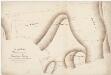
Rieden: Gemeinde- und Genossenschaftswaldungen: Gatter, Schürguggi, Cheller, Gstaltrain (Rain), Seewadel; Grundriss
Auftraggebung: Forstkommission Aufnahme und Zeichnung: Steiner, Rudolf, Forstmeister des 4. Kreises des Kantons Zürich, von Unterstrass, in Unterstrass
Dietlikon: Gemeindewaldung: Hard mit Seewadel, Looren (In der Loore), Grund, Strassholz, Gemeindplatz, Im Ritterspühl; Grundriss
1 : 1200 Mit handschriftlichen Eintragungen und Einzeichnungen, welche nach der eigentlichen Zeichnung des Plans, d. h. nach 1845, mit Tinte angebracht wurden. Auftraggebung: Forstkommission Aufnahme und Zeichnung: Steiner, Rudolf, Forstmeister des 4. Kreises des Kantons Zürich, von Unterstrass, in Unterstrass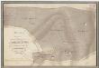
Rieden: Gemeinde- und Genossenschaftswaldungen: Gatter, Schürguggi, Cheller (Keller), Gstaltrain (Rain), Seewadel; Grundriss
1 : 2400 Mit Angabe des Flächeninhalts. Mit handschriftlichen Eintragungen und Einzeichnungen, welche im Rahmen der Revisionen des Plans in den Jahren 1893 und 1915 mit Tinte angebracht wurden. Auftraggebung: Forstkommission Aufnahme und Zeichnung: Steiner, Rudolf, Forstmeister des 4. Kreises des Kantons Zürich, von Unterstrass, in Unterstrass
Wallisellen: Östlicher Teil des Hofs in Niederschwerzenbach; Grundriss
Ohne Datumsangabe. Spitteler, Sigmund (1732-1818), Ingenieur und Strassenbauinspektor des Kantons Zürich, von Läufelfingen BL
Wallisellen: Winterthurerstrasse mit projektierter Wasserleitung von J. C. Guggenbühl entlang des Moosbachs und der Glatt bis zu seinem neuen Wohngebäude im Neugut; Situationsplan
1 : 1000 Mit Angabe der Namen von Grundeigentümern. Ohne Erstellungsdatumsangabe. Haas, F., Geometer
Wallisellen: Gemeinde- und Genossenschaftswaldungen: Gemeindewaldung; Grundriss
1 : 1000 Mit Verzeichnis der Flächeninhalte. Ausgangsplan: Grundbuchplan 26 der Gemeinde Wallisellen. Aufnahme: Bretscher, R., Grundbuchgeometer Zeichnung: Gebrüder Gossweiler, Technisches Büro, Grundbuchgeometer, in Dübendorf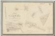
Dietlikon: Gemeindewaldung: Hard mit Herrenholz, Langholz, Majorenrüti, Haslerholz, Gubel, Dieweg; Grundrisse
1 : 1200 Mit Verzeichnis der Flächeninhalte. Mit handschriftlichen Eintragungen und Einzeichnungen, welche im Rahmen der Revision des Plans im Jahr 1908 mit roter Tinte und Grafitstift angebracht wurden. Auftraggebung: Forstkommission Aufnahme und Zeichnung: Steiner, Rudolf, Forstmeister des 4. Kreises des Kantons Zürich, von Unterstrass, in Unterstrass Revision: Hefti, Paul, Forstadjunkt im Zürcher Oberforstamt, von Zürich, in Zürich
Wallisellen: Gemeinde- und Genossenschaftswaldungen: Gemeindewaldung Metzg; Grundriss
1 : 1200 Mit handschriftlichen Einzeichnungen, welche im Rahmen der Revision des Plans im Jahr 1915 mit Tinte angebracht wurden. Auftraggebung: Direktion des Innern, Abteilung Forstpolizei Aufnahme und Zeichnung: Steiner, Rudolf, Forstmeister des 4. Kreises des Kantons Zürich, von Unterstrass, in Unterstrass
Wallisellen: Gemeinde- und Genossenschaftswaldungen: Genossenschaftswaldungen Seewadel, Wädemli (Wedemli), Gstaltenrein, Mittlerer Hau; Grundriss
Auftraggebung: Direktion des Innern, Abteilung Forstpolizei Aufnahme und Zeichnung: Steiner, Rudolf, Forstmeister des 4. Kreises des Kantons Zürich, von Unterstrass, in Unterstrass