Maps of Holice

Indikační skica mapy stabilního katastru pro město Holice II.
1 : 2880
Indikační skica mapy stabilního katastru pro obec Poběžovice u Holic VIII.
1 : 2880
Hollitz - c1963-1-002 - Kaiserpflichtexemplar der Landkarten des stabilen Katasters
1 : 2880
Hollitz - c1963-1-003 - Kaiserpflichtexemplar der Landkarten des stabilen Katasters
1 : 2880
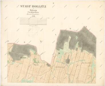
Hollitz - c1963-1-009 - Kaiserpflichtexemplar der Landkarten des stabilen Katasters
1 : 2880
Hollitz - c1963-1-001 - Kaiserpflichtexemplar der Landkarten des stabilen Katasters
1 : 2880
Hollitz - c1963-1-004 - Kaiserpflichtexemplar der Landkarten des stabilen Katasters
1 : 2880
Hollitz - c1963-1-006 - Kaiserpflichtexemplar der Landkarten des stabilen Katasters
1 : 2880
Hollitz - c1963-1-005 - Kaiserpflichtexemplar der Landkarten des stabilen Katasters
1 : 2880
Hollitz - c1963-1-007 - Kaiserpflichtexemplar der Landkarten des stabilen Katasters
1 : 2880
Hollitz - c1963-1-008 - Kaiserpflichtexemplar der Landkarten des stabilen Katasters
1 : 2880
Indikační skica mapy stabilního katastru pro obec Poběžovice u Holic I.-X.
1 : 2880
Indikační skica mapy stabilního katastru pro město Holice I.-XI.
1 : 2880
Pobieschowitz - c5855-1-006 - Kaiserpflichtexemplar der Landkarten des stabilen Katasters
1 : 2880
Pobieschowitz - c5855-1-003 - Kaiserpflichtexemplar der Landkarten des stabilen Katasters
1 : 2880
Pobieschowitz - c5855-1-001 - Kaiserpflichtexemplar der Landkarten des stabilen Katasters
1 : 2880
Pobieschowitz - c5855-1-005 - Kaiserpflichtexemplar der Landkarten des stabilen Katasters
1 : 2880
Pobieschowitz - c5855-1-002 - Kaiserpflichtexemplar der Landkarten des stabilen Katasters
1 : 2880
Pobieschowitz - c5855-1-004 - Kaiserpflichtexemplar der Landkarten des stabilen Katasters
1 : 2880
Pobieschowitz - c5855-1-007 - Kaiserpflichtexemplar der Landkarten des stabilen Katasters
1 : 2880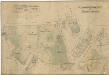
Porostní mapa revíru Holice
1 : 10000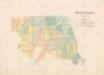
Mapa revíru Holice
1 : 10000
Indikační skica mapy stabilního katastru pro město Holice V.
1 : 2880
Indikační skica mapy stabilního katastru pro obec Poběžovice u Holic I., IV.
1 : 2880
Mapa revíru Vysoké Chvojno
1 : 800
Indikační skica mapy stabilního katastru pro obec Vysoké Chvojno I.-XI.
1 : 2880
Mapa revíru Holice
1 : 10000
Gradkartenblatt
1 : 25000 Holice-oblast (Pardubice, Česko) Böhm, Karl
Mapa politického okresu Pardubického