Maps of Býšť

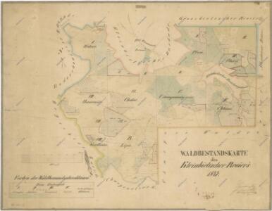
Porostní mapa revíru Bělečko
1 : 10000
Mapa revíru Bělečko
1 : 10000
Indikační skica mapy stabilního katastru pro obec Bělečko I.-VIII.
1 : 2880
Klein Beltsch (Belečko) - c0195-1-001 - Kaiserpflichtexemplar der Landkarten des stabilen Katasters
1 : 2880
Klein Beltsch (Belečko) - c0195-1-005 - Kaiserpflichtexemplar der Landkarten des stabilen Katasters
1 : 2880
Klein Beltsch (Belečko) - c0195-1-006 - Kaiserpflichtexemplar der Landkarten des stabilen Katasters
1 : 2880
Klein Beltsch (Belečko) - c0195-1-002 - Kaiserpflichtexemplar der Landkarten des stabilen Katasters
1 : 2880
Klein Beltsch (Belečko) - c0195-1-003 - Kaiserpflichtexemplar der Landkarten des stabilen Katasters
1 : 2880
Klein Beltsch (Belečko) - c0195-1-004 - Kaiserpflichtexemplar der Landkarten des stabilen Katasters
1 : 2880
Indikační skica mapy stabilního katastru pro obec Bělečko VI.
1 : 2880
Indikační skica mapy stabilního katastru pro obec Bělečko V.
1 : 2880
Indikační skica mapy stabilního katastru pro obec Bělečko II.
1 : 2880
Indikační skica mapy stabilního katastru pro obec Chvojenec a osadu Drahoš I., II.
1 : 2880
Indikační skica mapy stabilního katastru pro obec Vysoké Chvojno II., IV.
1 : 2880
Mapa okolí Hoděšovic
1 : 2880
Indikační skica mapy stabilního katastru pro obec Vysoké Chvojno II.
1 : 2880
Indikační skica mapy stabilního katastru pro obec Bělečko VI., VIII.
1 : 2880
Indikační skica mapy stabilního katastru pro obec Hoděšovice I., V.
1 : 2880
Indikační skica mapy stabilního katastru pro obec Bělečko III., VII.
1 : 2880
Indikační skica mapy stabilního katastru pro obec Běleč nad Orlicí XI.
1 : 2880
Indikační skica mapy stabilního katastru pro obec Běleč nad Orlicí X.
1 : 2880
Indikační skica mapy stabilního katastru pro obec Běleč nad Orlicí X., IX.
1 : 2880
Indikační skica mapy stabilního katastru pro obec Běleč nad Orlicí IX.
1 : 2880
Mapa revíru Chvojno
1 : 10000
Mapa revíru Chvojenec
1 : 6000
Mapa revíru Běleč
1 : 10000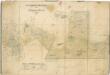
Porostní mapa revíru Vysoké Chvojno
1 : 10000
Chwogno - c8957-1-008 - Kaiserpflichtexemplar der Landkarten des stabilen Katasters
1 : 2880
Chwogno - c8957-1-003 - Kaiserpflichtexemplar der Landkarten des stabilen Katasters
1 : 2880
Chwogno - c8957-1-004 - Kaiserpflichtexemplar der Landkarten des stabilen Katasters
1 : 2880
Chwogno - c8957-1-001 - Kaiserpflichtexemplar der Landkarten des stabilen Katasters
1 : 2880
Chwogno - c8957-1-005 - Kaiserpflichtexemplar der Landkarten des stabilen Katasters
1 : 2880
Chwogno - c8957-1-002 - Kaiserpflichtexemplar der Landkarten des stabilen Katasters
1 : 2880
Chwogno - c8957-1-007 - Kaiserpflichtexemplar der Landkarten des stabilen Katasters
1 : 2880