Maps of Spojil

Porostní mapa revíru Hůrka
1 : 10000
Porostní mapa revíru Studánka
1 : 5000
Porostní mapa revíru Hůrka
1 : 5000
Porostní mapa revíru Studánka
1 : 5000
Mapa revíru Hůrka
1 : 5000
Indikační skica mapy stabilního katastru pro obec Studánka II.
1 : 2880
Studanka - c7497-1-002 - Kaiserpflichtexemplar der Landkarten des stabilen Katasters
1 : 2880
Studanka - c7497-1-001 - Kaiserpflichtexemplar der Landkarten des stabilen Katasters
1 : 2880
Mapa revíru Studánka
1 : 2880
Hospodářská mapa revíru Hůrka
1 : 2880
Hospodářská mapa revíru Studánka
1 : 2880
Indikační skica mapy stabilního katastru pro město Pardubice IX.
1 : 2880
Indikační skica mapy stabilního katastru pro obec Studánka I.
1 : 2880
Indikační skica mapy stabilního katastru pro obec Pardubičky I., ad II., III.
1 : 2880
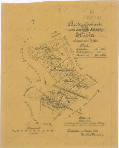
Mapa lesů města Pardubice nacházejících se mezi Spojilem, Kolodějemi, Sezemicemi a Počáply, tzv. Bělobranská dubina (koncept)
1 : 2529
Spogil - c7177-1-002 - Kaiserpflichtexemplar der Landkarten des stabilen Katasters
1 : 2880
Spogil - c7177-1-001 - Kaiserpflichtexemplar der Landkarten des stabilen Katasters
1 : 2880
Czerna bey Borr (Czerna u Bor) - c0877-1-001 - Kaiserpflichtexemplar der Landkarten des stabilen Katasters
1 : 2880
Czerna bey Borr (Czerna u Bor) - c0877-1-002 - Kaiserpflichtexemplar der Landkarten des stabilen Katasters
1 : 2880
Mapa obecních lesů revíru Koloděje
1 : 2591
Pardubitschek - c5634-1-002 - Kaiserpflichtexemplar der Landkarten des stabilen Katasters
1 : 2880
Pardubitschek - c5634-1-001 - Kaiserpflichtexemplar der Landkarten des stabilen Katasters
1 : 2880
Drozditz - c1540-1-002 - Kaiserpflichtexemplar der Landkarten des stabilen Katasters
1 : 2880
Drozditz - c1540-1-001 - Kaiserpflichtexemplar der Landkarten des stabilen Katasters
1 : 2880
Porostní mapa Bělobranského hájenství
1 : 2882
Pardubitz - c5633-1-006 - Kaiserpflichtexemplar der Landkarten des stabilen Katasters
1 : 2880
Pardubitz - c5633-1-007 - Kaiserpflichtexemplar der Landkarten des stabilen Katasters
1 : 2880
Pardubitz - c5633-1-003 - Kaiserpflichtexemplar der Landkarten des stabilen Katasters
1 : 2880
Pardubitz - c5633-1-009 - Kaiserpflichtexemplar der Landkarten des stabilen Katasters
1 : 2880
Pardubitz - c5633-1-011 - Kaiserpflichtexemplar der Landkarten des stabilen Katasters
1 : 2880
Pardubitz - c5633-1-005 - Kaiserpflichtexemplar der Landkarten des stabilen Katasters
1 : 2880
Pardubitz - c5633-1-002 - Kaiserpflichtexemplar der Landkarten des stabilen Katasters
1 : 2880
Pardubitz - c5633-1-004 - Kaiserpflichtexemplar der Landkarten des stabilen Katasters
1 : 2880
Pardubitz - c5633-1-001 - Kaiserpflichtexemplar der Landkarten des stabilen Katasters
1 : 2880
Pardubitz - c5633-1-010 - Kaiserpflichtexemplar der Landkarten des stabilen Katasters
1 : 2880