Maps of Český Krumlov
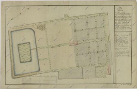
Geometrický plán zahrady a rybníka Benýtek u Nového dora 1

Krumau - c0990-1-008 - Kaiserpflichtexemplar der Landkarten des stabilen Katasters
1 : 2880
Krumau - c0990-1-005 - Kaiserpflichtexemplar der Landkarten des stabilen Katasters
1 : 2880
Krumau - c0990-1-002 - Kaiserpflichtexemplar der Landkarten des stabilen Katasters
1 : 2880
Krumau - c0990-1-006 - Kaiserpflichtexemplar der Landkarten des stabilen Katasters
1 : 2880
Krumau - c0990-1-001 - Kaiserpflichtexemplar der Landkarten des stabilen Katasters
1 : 2880
Krumau - c0990-1-003 - Kaiserpflichtexemplar der Landkarten des stabilen Katasters
1 : 2880
Krumau - c0990-1-004 - Kaiserpflichtexemplar der Landkarten des stabilen Katasters
1 : 2880
Krumau - c0990-1-007 - Kaiserpflichtexemplar der Landkarten des stabilen Katasters
1 : 2880
Krumau - c0990-1-009 - Kaiserpflichtexemplar der Landkarten des stabilen Katasters
1 : 2880
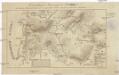
III. vojenské mapování 4452/4
1 : 25000
[Gradkartenblatt]
1 : 25000 Čechy (Česko)
Bestandeskarte der zum Plansker Complexe der Herrschaft Krumau gehörigen Reviere Neuhof u. Mistelholz
1 : 20000 Borová (Chvalšiny, Česko) Meinhard, Carl
Topographische Karte ... Herrschaft Krummau ...

Schulwandkarte des politischen Bezirkes Krumau Blatt 4

Schulwandkarte des politischen Bezirkes Krumau Blatt 4

Podrobné mapy zemí Koruny české v měřítku 1:75.000 a mapy vzdáleností všech míst při silnici ležících
1 : 75000 Lhenice (Prachatice, Česko : oblast) Bělohlav, Josef F. Topič
Podrobné mapy zemí Koruny české v měřítku 1:75.000 a mapa vzdáleností všech míst při silnici ležících - Lhenice - Český Krumlov. Průvodce statisticko-historický po všech místech na těchto mapách uvedených a rejstřík věcný názvů hor, potoků, řek, rybníků atd. Sešit 34. List 47,
1 : 75000
Kaplice a okolí
1 : 75000 Kaplice (Český Krumlov, Česko : oblast) Vojenský zeměpisný ústav
III. vojenské mapování 4452
1 : 75000
Lipenská přehrada

Český Krumlov
1 : 75000 Čechy (Česko) Vojenský zeměpisný ústav
Český Krumlov
1 : 75000 Čechy (Česko) Vojenský zeměpisný ústav
Krumau und Wallern
1 : 75000 Volary (Česko : oblast) Kohout, F. K. u. k. militär geographisches Institut
Krumau und Wallern
1 : 75000 Volary (Česko : oblast) K. u. k. Militärgeographisches Institut
Podrobná mapa Království českého, Markrabství moravského a Vévodství slezského
1 : 100000 Kaplice (Český Krumlov, Česko : oblast) Srp, Jan Jos. R. Vilímek
Podrobná mapa Království českého
1 : 100000 Kaplice (Český Krumlov, Česko : oblast) Srp, Jan Jaroslav Bursík
Karte des Gemeindegrenzen