Maps of Lomnice nad Lužnicí

Lomnice nad Lužnicí o. Jindřichův Hradec 1
1 : 2880
Smržov o. Jindřichův Hradec 1
1 : 2880
Geometrický plán rybníků Velký a Malý Tisý a Koclířov

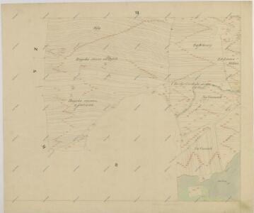
Situační plány rybníků Velký Tisý, Koclířov a odváděcích stok u Lomnice.Součástí technického elaborátu ve sporu sousedstva lomnického s Jeho Jasností knížetem Janem Adolfem ze Schwarzenberku ve příčině spouštění rybníků Velký Tisý a Koclířov před lovením, list 2 1
1 : 2880
Lomnice o. Jindřichův Hradec 1
1 : 2880
Lomnitz - c4219-1-005 - Kaiserpflichtexemplar der Landkarten des stabilen Katasters
1 : 2880
Lomnitz - c4219-1-006 - Kaiserpflichtexemplar der Landkarten des stabilen Katasters
1 : 2880
Lomnitz - c4219-1-002 - Kaiserpflichtexemplar der Landkarten des stabilen Katasters
1 : 2880
Lomnitz - c4219-1-008 - Kaiserpflichtexemplar der Landkarten des stabilen Katasters
1 : 2880
Lomnitz - c4219-1-011 - Kaiserpflichtexemplar der Landkarten des stabilen Katasters
1 : 2880
Lomnitz - c4219-1-001 - Kaiserpflichtexemplar der Landkarten des stabilen Katasters
1 : 2880
Lomnitz - c4219-1-007 - Kaiserpflichtexemplar der Landkarten des stabilen Katasters
1 : 2880
Lomnitz - c4219-1-003 - Kaiserpflichtexemplar der Landkarten des stabilen Katasters
1 : 2880
Lomnitz - c4219-1-009 - Kaiserpflichtexemplar der Landkarten des stabilen Katasters
1 : 2880
Lomnitz - c4219-1-010 - Kaiserpflichtexemplar der Landkarten des stabilen Katasters
1 : 2880
Lomnitz - c4219-1-012 - Kaiserpflichtexemplar der Landkarten des stabilen Katasters
1 : 2880
Lomnitz - c4219-1-004 - Kaiserpflichtexemplar der Landkarten des stabilen Katasters
1 : 2880
Mapa pozemků dvora Šaloun 1

Mapa pozemků dvora Šaloun 1

Smrzow - c7096-1-004 - Kaiserpflichtexemplar der Landkarten des stabilen Katasters
1 : 2880
Smrzow - c7096-1-005 - Kaiserpflichtexemplar der Landkarten des stabilen Katasters
1 : 2880
Smrzow - c7096-1-002 - Kaiserpflichtexemplar der Landkarten des stabilen Katasters
1 : 2880
Smrzow - c7096-1-007 - Kaiserpflichtexemplar der Landkarten des stabilen Katasters
1 : 2880
Smrzow - c7096-1-001 - Kaiserpflichtexemplar der Landkarten des stabilen Katasters
1 : 2880
Smrzow - c7096-1-006 - Kaiserpflichtexemplar der Landkarten des stabilen Katasters
1 : 2880
Smrzow - c7096-1-003 - Kaiserpflichtexemplar der Landkarten des stabilen Katasters
1 : 2880
Mapa pozemků dvora Šaloun 1

Geometrický plán rybníka Koclířov s přilehlými činžovními pozemky

Záměrná mapa-brouillon-Lomnice nad Lužnicí a jejího okolí 1