Maps of Dolní Bukovsko

Bzí o. České Budějovice 1
1 : 2880
Bzí o. České Budějovice 1
1 : 2880
Mapa nového vyměření režijních pozemků Nového dvora na statku Bzí 1
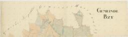
Bzí o. České Budějovice 1
1 : 2880
Geometrický plán dvora Bzí, rybníků, Pivovarský, Bartošovský, Sosnovský, Nový, Křovec a přilehlých činžovních pozemků 1
Geometrický plán dvora Bzí, rybníků, Pivovarský, Bartošovský, Sosnovský, Nový, Křovec a přilehlých činžovních pozemků 1

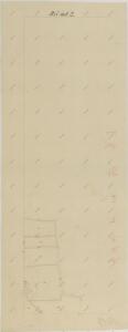
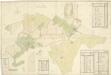
Mapa pozemků dvora Bzí 1

Záměrná mapa dvora Bzí 1
Geometrický plán pozemků dvorů na statku Bzí

Mapa propachtovaných pozemků dvora Bzí v letech 1902-1920 1
Geometrický plán pozemků dvorů na statku Bzí

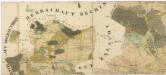
Bzy - c0730-1-002 - Kaiserpflichtexemplar der Landkarten des stabilen Katasters
1 : 2880
Bzy - c0730-1-001 - Kaiserpflichtexemplar der Landkarten des stabilen Katasters
1 : 2880
Bzy - c0730-1-006 - Kaiserpflichtexemplar der Landkarten des stabilen Katasters
1 : 2880
Bzy - c0730-1-005 - Kaiserpflichtexemplar der Landkarten des stabilen Katasters
1 : 2880
Bzy - c0730-1-004 - Kaiserpflichtexemplar der Landkarten des stabilen Katasters
1 : 2880
Bzy - c0730-1-003 - Kaiserpflichtexemplar der Landkarten des stabilen Katasters
1 : 2880
Zalschy - c9117-1-003 - Kaiserpflichtexemplar der Landkarten des stabilen Katasters
1 : 2880
Zalschy - c9117-1-001 - Kaiserpflichtexemplar der Landkarten des stabilen Katasters
1 : 2880
Zalschy - c9117-1-002 - Kaiserpflichtexemplar der Landkarten des stabilen Katasters
1 : 2880
Zalschy - c9117-1-006 - Kaiserpflichtexemplar der Landkarten des stabilen Katasters
1 : 2880
Zalschy - c9117-1-005 - Kaiserpflichtexemplar der Landkarten des stabilen Katasters
1 : 2880
Zalschy - c9117-1-004 - Kaiserpflichtexemplar der Landkarten des stabilen Katasters
1 : 2880
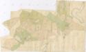
Porostní mapa polesí Bzí 1
1 : 15000
Mapa lesních cest v polesí Bzí 1
1 : 15000
Porostní mapa polesí Bzí 1
1 : 15000
Porostní mapa revíru Bzí pro desetiletí 1931/1940 1
1 : 15000
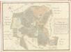
Generální mapa panství Třeboň a inkorporovaných statků Bzí, Lomnice, Borovany, Třeboň, Hamr a Val 1
Administrativní mapa třeboňského panství se statky Bzí,Lomnice, Borovany,Hamr a Val 1