Maps of okres Tábor

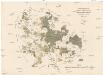
Geometrický plán rybníků u Zálší, Hartmanic, Hvozdna a Sobětic na statku Bzí: Nohavice, Kejhar, Dvorský, Hvězdář, Kobylník, Nový Kamenný a Rohlík 1

Zalschy - c9117-1-003 - Kaiserpflichtexemplar der Landkarten des stabilen Katasters
1 : 2880
Zalschy - c9117-1-001 - Kaiserpflichtexemplar der Landkarten des stabilen Katasters
1 : 2880
Zalschy - c9117-1-002 - Kaiserpflichtexemplar der Landkarten des stabilen Katasters
1 : 2880
Zalschy - c9117-1-006 - Kaiserpflichtexemplar der Landkarten des stabilen Katasters
1 : 2880
Zalschy - c9117-1-005 - Kaiserpflichtexemplar der Landkarten des stabilen Katasters
1 : 2880
Zalschy - c9117-1-004 - Kaiserpflichtexemplar der Landkarten des stabilen Katasters
1 : 2880
Hartmanitz - c1784-1-006 - Kaiserpflichtexemplar der Landkarten des stabilen Katasters
1 : 2880
Hartmanitz - c1784-1-004 - Kaiserpflichtexemplar der Landkarten des stabilen Katasters
1 : 2880
Hartmanitz - c1784-1-002 - Kaiserpflichtexemplar der Landkarten des stabilen Katasters
1 : 2880
Hartmanitz - c1784-1-003 - Kaiserpflichtexemplar der Landkarten des stabilen Katasters
1 : 2880
Hartmanitz - c1784-1-005 - Kaiserpflichtexemplar der Landkarten des stabilen Katasters
1 : 2880
Hartmanitz - c1784-1-007 - Kaiserpflichtexemplar der Landkarten des stabilen Katasters
1 : 2880
Hartmanitz - c1784-1-001 - Kaiserpflichtexemplar der Landkarten des stabilen Katasters
1 : 2880
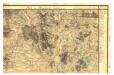
Generální mapa panství Třeboň a inkorporovaných statků Bzí, Lomnice, Borovany, Třeboň, Hamr a Val 1
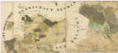
Administrativní mapa třeboňského panství se statky Bzí,Lomnice, Borovany,Hamr a Val 1

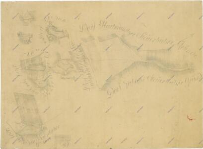
Situační plán statku Bzí a přilehlých pozemků 1

Přehledná mapa pozemků dvora Bzí 1

Mapa statku Bzí

Gradkartenblatt
1 : 25000 Týn nad Vltavou-oblast (Česko) Gerstner, Eduard von
Administrativní mapa třeboňského panství 1
1 : 57600
Uibersichts-Karte der hochfürstlich zu Schwarzenbergschen Domaine Frauenberg nach dem Stande im Jahre 1876
1 : 58000 Hluboká nad Vltavou-oblast (Česko) Danesch, Jos. Kreibich, František Jakub Jindřich
III. vojenské mapování 4353
1 : 75000
Wittingau und Moldauthein
1 : 75000 Týn nad Vltavou (Česko : oblast) Pflügl K. u. k. militär-geographisches Institut
Wittingau und Moldauthein
1 : 75000 Týn nad Vltavou (Česko : oblast) Pflügl K. u. k. Militärgeographisches Institut
Wittingau und Moldauthein
1 : 75000 Třeboň (Česko : oblast) K. u. k. Militärgeographisches Institut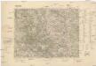
Třeboň
1 : 75000 Třeboň (Česko : oblast) Reichsamt für Landesaufnahme