Maps of Domoušice

Mapa činžovních pozemků v polesí Domoušice, v obcích Solopysky a Domoušice 1

Záměrná mapa polesí Domoušice, sekce 1 1

Mapa lesních činžovních pozemků v polesí Domoušice, list 4 1

Solopisk - c7142-1-003 - Kaiserpflichtexemplar der Landkarten des stabilen Katasters
1 : 2880
Solopisk - c7142-1-002 - Kaiserpflichtexemplar der Landkarten des stabilen Katasters
1 : 2880
Solopisk - c7142-1-004 - Kaiserpflichtexemplar der Landkarten des stabilen Katasters
1 : 2880
Solopisk - c7142-1-001 - Kaiserpflichtexemplar der Landkarten des stabilen Katasters
1 : 2880
Porostní mapa polesí Třeboc 1

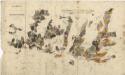
Bestandeskarte für die Excursion des böhmischen Forstvereins im Domaušicer Forstbezirke im Jahre 1881
Domoušice (Česko) Saitz, August Musis, Julius de Verlag des böhm. Forstvereins
Předloha hospodářské mapy polesí Domoušice 1

Porostní mapa polesí Domoušice 1
1 : 10000
Porostní mapa polesí Domoušice 1

Porostní mapa polesí Domoušice 1
1 : 10000
Porostní mapa polesí Domoušice 1
1 : 10000
Porostní mapa polesí Domoušice 1
1 : 10000
Obrysová mapa polesí Domoušice s hranicemi pozemkové reformy 1
1 : 10000
Porostní mapa polesí Domoušice 1
1 : 10000
Kopie katastrální mapy obce Kounov, list II 1

Porostní mapa polesí Domoušice, druhý exemplář 1
1 : 10000
Porostní mapa polesí Třeboc 1

Obrysová mapa polesí Domoušice 1
1 : 10000
Porostní mapa polesí Domoušice 1
1 : 15000
Přehledná mapa polesí Domoušice, Rovina, Selmice, Markvarec 3239
1 : 23000
Porostní mapa pro exkurzi Českého lesnického spolku v domoušickém lesním okrsku v roce 1881 1
1 : 20000
Porostní mapa pro exkurzi Českého lesnického spolku v domoušickém lesním okrsku v roce 1881 1
1 : 20000
Porostní mapa pro exkurzi Českého lesnického spolku v domoušickém lesním okrsku v roce 1881 1
1 : 20000
Porostní mapa pro exkurzi Českého lesnického spolku v domoušickém lesním okrsku v roce 1881 1
1 : 20000
Mapa polesí Třeboc, Obora, Přerubenice se zakreslením cest, lesů a hranic schwarzenberských a cizích polesí 1
Porostní mapa pro exkurzi Českého lesnického spolku v domoušickém lesním okrsku v roce 1881 1
1 : 20000