Maps of Veselí nad Lužnicí

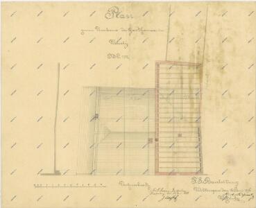
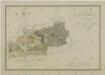
Plán přestavby hostince ve Veselí nad Lužnicí 1
1 : 100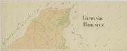
Horusice o. Tábor 1
1 : 2880
Wessely - c8515-1-003 - Kaiserpflichtexemplar der Landkarten des stabilen Katasters
1 : 2880
Wessely - c8515-1-004 - Kaiserpflichtexemplar der Landkarten des stabilen Katasters
1 : 2880
Wessely - c8515-1-002 - Kaiserpflichtexemplar der Landkarten des stabilen Katasters
1 : 2880
Wessely - c8515-1-001 - Kaiserpflichtexemplar der Landkarten des stabilen Katasters
1 : 2880
Mezimosti - c4570-1-006 - Kaiserpflichtexemplar der Landkarten des stabilen Katasters
1 : 2880
Mezimosti - c4570-1-005 - Kaiserpflichtexemplar der Landkarten des stabilen Katasters
1 : 2880
Mezimosti - c4570-1-001 - Kaiserpflichtexemplar der Landkarten des stabilen Katasters
1 : 2880
Mezimosti - c4570-1-004 - Kaiserpflichtexemplar der Landkarten des stabilen Katasters
1 : 2880
Mezimosti - c4570-1-002 - Kaiserpflichtexemplar der Landkarten des stabilen Katasters
1 : 2880
Mezimosti - c4570-1-003 - Kaiserpflichtexemplar der Landkarten des stabilen Katasters
1 : 2880
Horusitz - c2195-1-006 - Kaiserpflichtexemplar der Landkarten des stabilen Katasters
1 : 2880
Horusitz - c2195-1-003 - Kaiserpflichtexemplar der Landkarten des stabilen Katasters
1 : 2880
Horusitz - c2195-1-001 - Kaiserpflichtexemplar der Landkarten des stabilen Katasters
1 : 2880
Horusitz - c2195-1-004 - Kaiserpflichtexemplar der Landkarten des stabilen Katasters
1 : 2880
Horusitz - c2195-1-008 - Kaiserpflichtexemplar der Landkarten des stabilen Katasters
1 : 2880
Horusitz - c2195-1-007 - Kaiserpflichtexemplar der Landkarten des stabilen Katasters
1 : 2880
Horusitz - c2195-1-005 - Kaiserpflichtexemplar der Landkarten des stabilen Katasters
1 : 2880
Horusitz - c2195-1-002 - Kaiserpflichtexemplar der Landkarten des stabilen Katasters
1 : 2880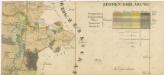
Administrativní mapa třeboňského panství se statky Bzí,Lomnice, Borovany,Hamr a Val 1

Generální mapa panství Třeboň a inkorporovaných statků Bzí, Lomnice, Borovany, Třeboň, Hamr a Val 1
Situační plán statku Hamr-Val a přilehlých pozemků 1

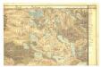
III. vojenské mapování 4353/2
1 : 25000
[Gradkartenblatt]
1 : 25000 Veselí nad Lužnicí-oblast (Česko)
Gradkartenblatt
1 : 25000 Veselí nad Lužnicí-oblast (Česko) Gerstner, Eduard von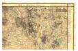

Situační plán silnic Soběslav-Kardašova Řečice a Mezimostí-Kardašova Řečice-Pleše 1