Maps of okres Tachov

Katastrální mapa obce Pavlův Studenec WC-XVI-20 ch
1 : 2880
Hospodářská mapa revíru Jedlina I. sekce
1 : 5760
Hospodářská mapa revíru Jedlina I. sekce
1 : 5760
Hospodářská mapa revíru Ostrůvek
1 : 5760
Katastrální mapa obce Milíře
1 : 2880
Lesní hospodářská mapa revíru Milíře
1 : 5747
Lesní hospodářská mapa revíru Pavlův Studenec
1 : 5835
Porostní mapa revíru Jedlina
1 : 11520
Porostní mapa revíru Pavlův Studenec
1 : 11520
Lesní mapa revíru Tachov
1 : 10000
Porostní mapa lesního statku Ostrůvek
1 : 11520
Záměrná mapa parcel obce Pavlův Studenec
1 : 2880
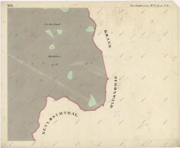
Paulusbrunn - c5672-1-006 - Kaiserpflichtexemplar der Landkarten des stabilen Katasters
1 : 2880
Paulusbrunn - c5672-1-008 - Kaiserpflichtexemplar der Landkarten des stabilen Katasters
1 : 2880
Paulusbrunn - c5672-1-010 - Kaiserpflichtexemplar der Landkarten des stabilen Katasters
1 : 2880
Paulusbrunn - c5672-1-014 - Kaiserpflichtexemplar der Landkarten des stabilen Katasters
1 : 2880
Paulusbrunn - c5672-1-009 - Kaiserpflichtexemplar der Landkarten des stabilen Katasters
1 : 2880
Paulusbrunn - c5672-1-013 - Kaiserpflichtexemplar der Landkarten des stabilen Katasters
1 : 2880
Paulusbrunn - c5672-1-007 - Kaiserpflichtexemplar der Landkarten des stabilen Katasters
1 : 2880
Paulusbrunn - c5672-1-002 - Kaiserpflichtexemplar der Landkarten des stabilen Katasters
1 : 2880
Paulusbrunn - c5672-1-012 - Kaiserpflichtexemplar der Landkarten des stabilen Katasters
1 : 2880
Paulusbrunn - c5672-1-001 - Kaiserpflichtexemplar der Landkarten des stabilen Katasters
1 : 2880
Paulusbrunn - c5672-1-004 - Kaiserpflichtexemplar der Landkarten des stabilen Katasters
1 : 2880
Paulusbrunn - c5672-1-017 - Kaiserpflichtexemplar der Landkarten des stabilen Katasters
1 : 2880
Paulusbrunn - c5672-1-003 - Kaiserpflichtexemplar der Landkarten des stabilen Katasters
1 : 2880
Paulusbrunn - c5672-1-011 - Kaiserpflichtexemplar der Landkarten des stabilen Katasters
1 : 2880
Paulusbrunn - c5672-1-005 - Kaiserpflichtexemplar der Landkarten des stabilen Katasters
1 : 2880
Paulusbrunn - c5672-1-015 - Kaiserpflichtexemplar der Landkarten des stabilen Katasters
1 : 2880
Paulusbrunn - c5672-1-016 - Kaiserpflichtexemplar der Landkarten des stabilen Katasters
1 : 2880