Maps of Horšovský Týn

Katastrální mapa obce Blížejov ZS-XII-24 df
1 : 2880
Blisowa (Blizow) - c0286-1-001 - Kaiserpflichtexemplar der Landkarten des stabilen Katasters
1 : 2880
Blisowa (Blizow) - c0286-1-003 - Kaiserpflichtexemplar der Landkarten des stabilen Katasters
1 : 2880
Blisowa (Blizow) - c0286-1-002 - Kaiserpflichtexemplar der Landkarten des stabilen Katasters
1 : 2880
Prziwosten (Prziwozecz) - c6260-1-002 - Kaiserpflichtexemplar der Landkarten des stabilen Katasters
1 : 2880
Prziwosten (Prziwozecz) - c6260-1-001 - Kaiserpflichtexemplar der Landkarten des stabilen Katasters
1 : 2880
III. vojenské mapování 4150/3
1 : 25000
[Kartenblatt]
1 : 25000 Horšovský Týn (Česko : oblast) Reichsamt für Landesaufnahme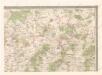
Mapa politického okresu Domažlického

Gradkartenblatt
1 : 25000 Horšovský Týn-oblast (Česko) Bulla, Eduard


Podrobné mapy zemí Koruny české v měřítku 1:75.000 a mapy vzdáleností všech míst při silnici ležících
1 : 75000 Domažlice (Česko : oblast) Bělohlav, Josef F. Topič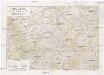
Chodsko
1 : 100000 Chodsko (Česko) Klub českých turistů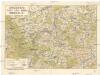
Chodsko
1 : 100000 Chodsko (Česko) Klub českých turistů
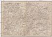
Bischofteinitz und Nürschan
1 : 75000 Horšovský Týn (Česko : oblast) Mulacz, J. K. u. k. militär-geographisches Institut
Bischofteinitz und Nürschan
1 : 75000 Horšovský Týn (Česko : oblast) Mulacz, J. K. u. k. Militärgeographisches Institut
Bischofteinitz und Nürschan
1 : 75000 Horšovský Týn (Česko : oblast) K. u. k. Militärgeographisches Institut
III. vojenské mapování 4150
1 : 75000
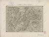
Domažlice a okolí
1 : 75000 Domažlice (Česko : oblast) Vojenský zeměpisný ústav
Horšovský Týn
1 : 75000 Horšovský Týn-oblast (Česko) Vojenský zeměpisný ústav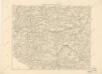
Podrobná místopisná mapa Království Českého

Podrobná mapa Království českého
1 : 100000 Domažlice (Česko : oblast) Srp, Jan Jaroslav Bursík
II. vojenské mapování 23
1 : 144000
Das Tauser Grenzgebiet
1 : 200000 Chodsko (Česko)
Bischofteinitz und Nurschan.
from Spezialkarte der osterreichisch-ungarischen Monarchie.
Spezial Karte von Böhmen
II. vojenské mapování 24
1 : 144000
Taus und Klattau.
from Spezialkarte der osterreichisch-ungarischen Monarchie.