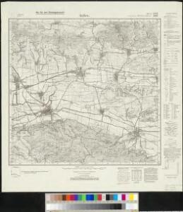
Maps of Kelbra (Kyffhäuser)

Messtischblatt 2600, neue Nr. 4532 : Kelbra, 1938 Kelbra
1 : 250000 Kelbra. - Hrsg. 1905, einz. Nachtr. 1934, redakt. Änd. [19]38. - 1:25000. - [Berlin]: Reichsamt für Landesaufnahme, 1938. - 1 Kt.
Accurate Geographische Charte dar Graeslichen Stolbergl. als Hohnstein, Stolberg, Hayn, Berenroda, Ebersburg, Ufftrungen, Rosla, und Questenb. nebst unterschiedliche angräntzenden
1 : 90000 Mollova mapová sbírka Schenk, Pieter Schenk, Peter II
Comitatus Stolbergensis delineatio geographià
1 : 90000 Mollova mapová sbírka Seutter, Matthäus Seutter, Matthäus
Comitatus Stolbergensis...

Comitatvs Hohnstein nec non dynastiarvm Lohra et Klettenberg
1 : 101400 studio Homannianorum heredum
Comitatus Stolbergensis delineatio geographia, praefecturas Hohnstein, Stolberg, Hayn, Berenroda, Ebersburg, Ufftrungen, Rosla et Questen cum limitibus et vicinia accurate exhibens
1 : 90000 Anhaltsko (Německo) Seutter, Matthäus Lotter, Tobias Conrad M. Seutter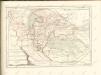

Comitatus Stolbergici ad Hercyniam
1 : 65000 Mollova mapová sbírka Penther, Johann Friedrich Homann, Johann Baptista - dědici
Accurate geographische Charte der Graeftlichen Stolbergl. AEmter, als Hohnstein, Stolberg, Hayn, Berenroda, Ebersburg, Wolfsberg, Ufftrungen, Rosla, und Questenb. nebst unterschiedliche angräntzenden
1 : 85000 Sasko (Německo) Schenk, Pieter P. Schenk
Karte des Fürstentums Schwarzburg-Sondershausen in Thüringen
Mit drei Zeichnungen eines Lust- und Jagdschlosses, der Residenzstadt Sondershausen und dem Amts- und Marktflecken Ebeleben. Mit Erklärung der verwendeten Zeichen. Meisner, Johann Wilhelm
113. Sondershausen, uit: Topographische Uebersichtskarte des Deutschen Reiches / herausgegeben v. d. Kartogr. Abt. d. Königl. Preuß. Landesaufnahme
1 : 200000 titelvariant: Topogr. Übersichtskarte des Deutschen Reiches; Annotatie: Titel boven bladen ook: Topogr. Übersichtskarte des Deutschen Reiches; Annotatie geografische gegevens: Op elk blad twee maatstokken: 10 Kilometer = 5,5 cm; 1 geogr. Meile = 3,6 cm; Legenda onder op elk blad Königlich Preußische Landesaufnahme. Kartographische Abtheilung [S.l : Königlich Preußische Landesaufnahme, Kartographische Abtheilung]
Comitatvs Hohnstein
1 : 100000 Mollova mapová sbírka Homann, Johann Baptist Homann, Johann Baptista - dědici
Mansfeldiae comitatvs descriptio
1 Karte : Kupferdruck ; 36 x 41 cm Stella; Ortelius; Hogenberg s.n.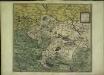
Mansfeldiae comitatvs descriptio
1 Karte : Kupferdruck ; 36 x 41 cm Stella; Ortelius; Hogenberg s.n.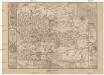
Mansfeldici comitatus typus chorographicus
1 : 180000 Halle an der Saale-oblast (Německo) Stella, Tilemann Mansfeld, Bruno a M. Iohanne Mellingero
Comitatvs Mansfeldiae Descriptio
1 : 210000 Mollova mapová sbírka Stella, Tilemann Schenk, Peter I
Comitatvs Mansfeldiae Descriptio
1 : 210000 Mollova mapová sbírka Stella, Tilemann Janssonius, Johannes I
Mansfeldiae Comitatvs descriptio auctore Tilemanno Stella Sig.
1 : 180000 Mollova mapová sbírka Stella, Tilemann Hogenberg, Franz Braun, Georg
Mansfeldia Comitatvs
1 : 170000 Mollova mapová sbírka Stella, Tilemann Blaeu, Joan I.
Mansfeldia Comitatvs
1 : 240000 Mollova mapová sbírka Merian, Matthaeus Merian, Matthäus

Sectio Inferior, Dvcatvs Vinariensem, nec non Isenacensis Partes Boreales et Orientales, Principatvm Qverfvrtensem, ut et Territorium Erfvrtense, Comitatvm Beichlingen, Balifiatum Thvringiae et alia repraesentans
1 : 200000 Mollova mapová sbírka Zollmann, Johann Wilhelm Oetinger, Christ. Friedrich Homann, Johann Baptista - dědici
MANSFELDIA | COMITATVS
Auctore Tilemanno Stella Sig. Apud Guiljelm. Blaeu.
Mansfeldiae Comitatus Descriptio. [Karte], in: Theatrum orbis terrarum, S. 130.
1 Karte aus Atlas Ortelius, Abraham
Charte von dem Harz Gebirge und einem Theile der umliegenden Gegenden
1 : 200000 Harz (Německo) Julius, Friedrich Berghaus, Heinrich Karl Wilhelm C.W. Ramdohr's Hof-Kunsthandlung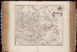
Mansfeldia comitatvs / auctore Tilemanno Stella sig
1 : 170000 Annotatie: Origineel is Blad 99 in atlas factice; Annotatie geografische gegevens: Schaalvermelding op kaart: 2 Milliaria Germanica communia; Kaart toont het graafschap Mansfeld in het gebied tussen Aschersleben, Halle an der Saale, Wiehe Unstruttal en Stolberg Tilemann Stella 1525-1589 [Amsterdami : apud Guiljelm. Blaeu]
Mansfeldiae Comitatus Descriptio. [Karte], in: Theatrum orbis terrarum, S. 222.
1 Karte aus Atlas Ortelius, Abraham Vrients, Jan Baptista
Mansfeldia Comitatus [Karte], in: Theatrum orbis terrarum, sive, Atlas novus, Bd. 1, S. 245.
1 Karte aus Atlas Blaeu, Joan Blaeu, Willem Janszoon
Comitatus Mansfeldia [Karte], in: Gerardi Mercatoris et I. Hondii Newer Atlas, oder, Grosses Weltbuch, Bd. 1, S. 289.
1 Karte aus Atlas Mercator, Gerhard und Hondius, Jodocus Jansson, Jan