Maps of Kaiserpfalz

Meßtischblatt 4734 : Wiehe, 1949
1 : 250000 Wiehe. - Aufn. 1903, hrsg. 1905, letzte Nachtr. 1931, hrsg. 1940. - 1:25000. - [Berlin]: Reichsamt für Landesaufnahme, 1940. - 1 Kt.
Meßtischblatt 2746 : Wiehe, 1905
1 : 250000 Wiehe. - Aufn. 1903. - 1:25000. - [Berlin]: Reichsamt für Landesaufnahme, 1905. - 1 Kt.
114. Halle, uit: Topographische Uebersichtskarte des Deutschen Reiches / herausgegeben v. d. Kartogr. Abt. d. Königl. Preuß. Landesaufnahme
1 : 200000 titelvariant: Topogr. Übersichtskarte des Deutschen Reiches; Annotatie: Titel boven bladen ook: Topogr. Übersichtskarte des Deutschen Reiches; Annotatie geografische gegevens: Op elk blad twee maatstokken: 10 Kilometer = 5,5 cm; 1 geogr. Meile = 3,6 cm; Legenda onder op elk blad Königlich Preußische Landesaufnahme. Kartographische Abtheilung [S.l : Königlich Preußische Landesaufnahme, Kartographische Abtheilung]
[Kaart], uit: Shell-Saalekarte
1 : 100000 titelvariant: Die Saale; Annotatie: Titel en ondertitel op omslag: Die Saale : von Saalfeld-Weissenfels; Verso: informatie [S.l. : Shell Reisedienst]
Sectio Inferior, Dvcatvs Vinariensem, nec non Isenacensis Partes Boreales et Orientales, Principatvm Qverfvrtensem, ut et Territorium Erfvrtense, Comitatvm Beichlingen, Balifiatum Thvringiae et alia repraesentans
1 : 200000 Mollova mapová sbírka Zollmann, Johann Wilhelm Oetinger, Christ. Friedrich Homann, Johann Baptista - dědici
Mansfeldia Comitatus [Karte], in: Novus Atlas, das ist, Weltbeschreibung, Bd. 1, S. 162.
1 Karte aus Atlas Blaeu, Joan Blaeu, Willem Janszoon
Mansfeldia Comitatus [Karte], in: Le théâtre du monde, ou, Nouvel atlas contenant les chartes et descriptions de tous les païs de la terre, Bd. 1, S. 193.
1 Karte aus Atlas Blaeu, Willem Janszoon und Blaeu, Joan Blaeu, Willem Janszoon

Abriß der am fünften des Wintermondes im 1757sten Jahre bey Roßbach im Merseburgischen zwischen der roemisch-kaiserlichen Reichs-Armee, unter des Prinzen von Hildburgshausen Durchlaucht Commando, als Reichsfeldmarschall, nebst der damit vereinigten koeniglichen franzoesischen Armee, unter des Prinzen von Soubise Durchlaucht Commando, und zwischen dem koeniglichen preußischen von dem Koenige selbst angefuehrten Kriegsheere, gehaltenen Schlacht, wie auch der Gegenden, welche durch die Scharmuetzel und den kleinen Krieg merkwuerdig geworden sind
Rossbach (Německo) Trattner, Johann Thomas bey Johann Thomas Trattnern
Abriß der am fünften des Wintermondes im 1757sten Jahre bey Roßbach im Merseburgischen zwischen der Römisch-Kaiserlichen Reichs-Armee, unter des Prinzen von Hildburgshausen Durchlaucht Commando, als Reichsfeldmarschall, nebst der damit vereinigten Königlichen französischen Armee, unter des Prinzen von Soubise Durchlaucht Commando, und zwischen dem Königlichen preußischen von dem Könige selbst angeführten Kriegsheere, gehaltenen Schlacht
1 : 300000 Mollova mapová sbírka Trattner, Johann Thomas Trattner, Johann Thomas von
Erfurt
1 : 300000 R. Mittelbach
Fürstentum Schwarzburg-Rudolstadt 1823 Verwaltungsstruktur
Schwarzburg-Rudolstadt Verwaltung Kunz, Andreas ; Moeschl, Joachim Robert
Fürstentum Schwarzburg-Rudolstadt 1820 Verwaltungsstruktur
Schwarzburg-Rudolstadt Verwaltung Kunz, Andreas ; Moeschl, Joachim Robert
Fürstentum Schwarzburg-Sondershausen 1820 Verwaltungsstruktur
Schwarzburg-Sondershausen Verwaltung Kunz, Andreas ; Moeschl, Joachim Robert
Accurate geographische Delineation des Stiffts Naumburg und Zeitz mit denen churfürstl. sächsl. Schul-Ambt Pforta Pegau, Tautenburg und angrenzenden etc
1 : 140000 Naumburg an der Saale (Německo) Schenk, Pieter P. Schenk
Mansfeldiae Comitatus Descriptio. [Karte], in: Theatrum orbis terrarum, S. 222.
1 Karte aus Atlas Ortelius, Abraham Vrients, Jan Baptista
Tvringiae noviss. descript
1 Karte : Kupferdruck ; 28 x 20 cm Mellinger; Ortelius s.n.
Tvringiae noviss. descript
1 Karte : Kupferdruck ; 28 x 20 cm Mellinger; Ortelius s.n.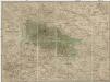
Special Charte von dem Harz-Gebirge und den umliegenden Ländern
Harz-oblast (Německo) von dem Geographischen Institute

Geographische Charte
1 : 300000 Mollova mapová sbírka Zollmann, Friedrich

Thvringia Landgraviatvs
1 : 420000 Mollova mapová sbírka Merian, Matthaeus Merian, Matthäus
Thvringia
1 Karte : Kupferdruck ; 33 x 40 cm Mercator; Hondius sumptibus Henrici Hondÿ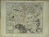
Thvringia
1 Karte : Kupferdruck ; 33 x 40 cm Mercator s.n.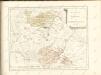

Turingiae Noviss. Descript. [Karte], in: Theatrum orbis terrarum, S. 137.
1 Karte aus Atlas Ortelius, Abraham
Karte der Thüringer Eisenbahn
1 : 218000 Kunstanstalt von Mädel II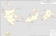
Herzogtum Sachsen-Gotha-Altenburg 1823 Verwaltungsstruktur
Sachsen-Altenburg Verwaltung Kunz, Andreas ; Moeschl, Joachim Robert


