Maps of Niesky

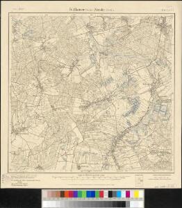
Meßtischblatt 4754 : Niesky, 1938
1 : 250000 Niesky. - Umdr.-Ausg., aufgen. 1900, hrsg. 1906, bericht. - 1:25000. - Leipzig, 1938. - 1 Kt.
Meßtischblatt 40.(2753) : Niesky, 1930
1 : 250000 Niesky. - Aufgen. 1900, hrsg. 1906, bericht. sächs. Teil 1923, preuß. Teil 1930. - 1:25000. - Leipzig, 1930. - 1 Kt.
Meßtischblatt 40.(2753) : Feldkaiser (Sächs.) - Niesky (Preuß.), 1919
1 : 250000 Feldkaiser (Sächs.) - Niesky (Preuß.). - Aufgen. 1900, hrsg. 1906, einz. Nachtr. 1919. - 1:25000. - Leipzig, 1919. - 1 Kt.
III. vojenské mapování 3553
1 : 75000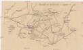
Überfall bei Hochkirch, am 14. Oktober 1758
Plan de Battaille du 14. Octobre 1758 à Hoch-Kirch en Lusace
1 : 110000 Mollova mapová sbírka Fridrich, Jacob Andreas Fridrich, Jacob Andreas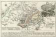
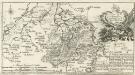
Plan de Bataille welche den 14 Octobr. 1758 v. den Kays. König. Ung. König. Preuss. Armeen bey Höh-Kirchen in dem Margraftum Ober Lausiz geliefert worden
1 : 110000 Mollova mapová sbírka Fridrich, Jacob Andreas Fridrich, Jacob Andreas
Schluckenau.
from Spezialkarte der osterreichisch-ungarischen Monarchie.
117. Görlitz, uit: Topographische Uebersichtskarte des Deutschen Reiches / herausgegeben v. d. Kartogr. Abt. d. Königl. Preuß. Landesaufnahme
1 : 200000 titelvariant: Topogr. Übersichtskarte des Deutschen Reiches; Annotatie: Titel boven bladen ook: Topogr. Übersichtskarte des Deutschen Reiches; Annotatie geografische gegevens: Op elk blad twee maatstokken: 10 Kilometer = 5,5 cm; 1 geogr. Meile = 3,6 cm; Legenda onder op elk blad Königlich Preußische Landesaufnahme. Kartographische Abtheilung [S.l : Königlich Preußische Landesaufnahme, Kartographische Abtheilung]
Die Ober Lausitz
1 : 25000 Horní Lužice (Německo) Riedig, Christian G. Schreibers Erben
Die Ober Lausitz
1 : 260000 Horní Lužice (Německo) Riedig, Christian G. Jordan, I. P. Schreibers Erben
Geographische Verzeichnung des BVDISSINISCHEN CREISES in dem Marggrafthum OBER LAVSITZ
1 : 180000 Budyšín (Německo) von Homaennischen Erben
Geographische Verzeichnung des Bvdissinischen Creises in dem Marggrafthum Ober Lavsitz
1 : 185000 Budyšín (Německo) von Homaennischen Erben
Geographische Verzeichnung des Bvdissinischen Creises in dem Marggrafthum Ober Lavsitz
1 : 180000 Mollova mapová sbírka Homann, Johann Baptist Homann, Johann Baptista - dědici
Geographische Verzeichnung des GOERLIZER CREISES mit dem QVEISS-CREISE welches zusammen ist der Ostliche Theil von dem Marggrafthum OBER LAVSITZ
1 : 180000 Görlitz (Německo) vom Homaennischen Erben
Geographische Verzeichnung des Goerlizer Creises mit dem Qveiss-Creise
1 : 176200 Görlitz (Německo) Homaennischen Erben
Geographische Verzeichnung des Goerlizer Creises mit dem Qveiss-Creise welches zusammen ist der Ostliche Theil von dem Marggrafthum Ober Lavsiz
1 : 180000 Mollova mapová sbírka Homann, Johann Baptist Homann, Johann Baptista - dědici
Generální mapa ČSR

Generální mapa Protektorátu Čechy a Morava

Sbírka map a diagramů použitých na mírových konferencích v Paříži v letech 1919 - 1920

Cottbus 75, uit: Special-Karte von Mittel-Europa / nach amtlichen Quellen bearbeitet von W. Liebenow
1 : 300000 titelvariant: W. Liebenow's Mittel-Europa; Annotatie: Titel boven de bladen: W. Liebenow's Mittel-Europa Johannes Wilhelm Liebenow 1822-1897 Frankfurt a. M. : Ludwig Ravenstein
Die Markgrafschaft Oberlausitz in ihre Kreise eingetheilt.
1 : 363000 Horní Lužice (Německo) Hübner, Johann Homann, Johann Baptist
La Haute Lusace
1 : 180000 Mollova mapová sbírka Le Rouge, Georges-Louis Le Rouge, Georges-Louis
Principatvs Silesiae Schwidnicensis
1 : 128000 Svídnice-oblast (Polsko) Wieland, Johann Wolfgang Schubarth, Matthäus Hered. Homannianis
A map of the country round Dresden, with the towns and fortresses which the several armies have occupied during the campaign
1 : 475000
Ober Lausitz entworffen, und in Kupffer gestochen
1 : 230000 Mollova mapová sbírka Schreiber, Johann Georg Schreiber, Johann Georg
Lusatia Superior
1 : 260000 Mollova mapová sbírka Scultetus, Bartholomaeus Janssonius Van Waesberge, Johannes II
Lusatia Superior
1 : 260000 Mollova mapová sbírka Scultetus, Bartholomaeus Schenk, Peter I
Lusatia Superior
1 : 260000 Mollova mapová sbírka Funck, David Funck, David