Maps of Dolní Podluží

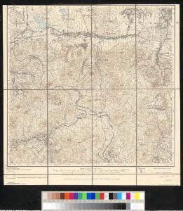
Meßtischblatt 106 : Waltersdorf, 1936
1 : 250000 Waltersdorf. - Aufgen. 1928, einz. Nachtr. 1936. - 1:25000. - Leipzig, 1936. - 1 Kt.
Meßtischblatt 106 : Waltersdorf, 1905
1 : 250000 Waltersdorf. - Aufgen. 1899, rev. 1900. - 1:25000. - Leipzig, 1905. - 1 Kt.
Tollenstein mit der Ortschaft Innozenzidorf in Böhmen
1 : 2880 Lesné (Jiřetín pod Jedlovou, Česko)
Georgenthal, Leitm[eritzer] Kr[eis]
1 : 2880 Jiřetín pod Jedlovou (Česko : oblast)
Niedergrund - c1362-2-002 - Kaiserpflichtexemplar der Landkarten des stabilen Katasters
1 : 2880
Niedergrund - c1362-2-006 - Kaiserpflichtexemplar der Landkarten des stabilen Katasters
1 : 2880
Niedergrund - c1362-2-004 - Kaiserpflichtexemplar der Landkarten des stabilen Katasters
1 : 2880
Niedergrund - c1362-2-001 - Kaiserpflichtexemplar der Landkarten des stabilen Katasters
1 : 2880
Niedergrund - c1362-2-007 - Kaiserpflichtexemplar der Landkarten des stabilen Katasters
1 : 2880
Niedergrund - c1362-2-008 - Kaiserpflichtexemplar der Landkarten des stabilen Katasters
1 : 2880
Niedergrund - c1362-2-003 - Kaiserpflichtexemplar der Landkarten des stabilen Katasters
1 : 2880
Niedergrund - c1362-2-005 - Kaiserpflichtexemplar der Landkarten des stabilen Katasters
1 : 2880
Ober Lichtenwalde - c2159-2-004 - Kaiserpflichtexemplar der Landkarten des stabilen Katasters
1 : 2880
Ober Lichtenwalde - c2159-2-006 - Kaiserpflichtexemplar der Landkarten des stabilen Katasters
1 : 2880
Ober Lichtenwalde - c2159-2-001 - Kaiserpflichtexemplar der Landkarten des stabilen Katasters
1 : 2880
Ober Lichtenwalde - c2159-2-005 - Kaiserpflichtexemplar der Landkarten des stabilen Katasters
1 : 2880
Ober Lichtenwalde - c2159-2-007 - Kaiserpflichtexemplar der Landkarten des stabilen Katasters
1 : 2880
Ober Lichtenwalde - c2159-2-008 - Kaiserpflichtexemplar der Landkarten des stabilen Katasters
1 : 2880
Ober Lichtenwalde - c2159-2-003 - Kaiserpflichtexemplar der Landkarten des stabilen Katasters
1 : 2880
Ober Lichtenwalde - c2159-2-002 - Kaiserpflichtexemplar der Landkarten des stabilen Katasters
1 : 2880
Kreibitz Neudörfel - c5196-1-004 - Kaiserpflichtexemplar der Landkarten des stabilen Katasters
1 : 2880
Kreibitz Neudörfel - c5196-1-001 - Kaiserpflichtexemplar der Landkarten des stabilen Katasters
1 : 2880
Kreibitz Neudörfel - c5196-1-003 - Kaiserpflichtexemplar der Landkarten des stabilen Katasters
1 : 2880
Kreibitz Neudörfel - c5196-1-005 - Kaiserpflichtexemplar der Landkarten des stabilen Katasters
1 : 2880
Kreibitz Neudörfel - c5196-1-007 - Kaiserpflichtexemplar der Landkarten des stabilen Katasters
1 : 2880
Kreibitz Neudörfel - c5196-1-002 - Kaiserpflichtexemplar der Landkarten des stabilen Katasters
1 : 2880
Kreibitz Neudörfel - c5196-1-006 - Kaiserpflichtexemplar der Landkarten des stabilen Katasters
1 : 2880
Tannendörfel - c2809-1-002 - Kaiserpflichtexemplar der Landkarten des stabilen Katasters
1 : 2880
Tannendörfel - c2809-1-003 - Kaiserpflichtexemplar der Landkarten des stabilen Katasters
1 : 2880