Maps of Lehrte

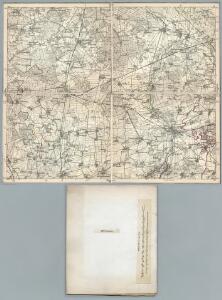
287. Lehrte.
1 : 100000 Reichsamt fur Landesaufnahme
Composite: 287. Lehrte.
1 : 100000 Reichsamt fur Landesaufnahme
Meßtischblatt 1956 : Haimar, 1924
1 : 250000 Haimar. - Aufn. 1896, bericht. 1924. - 1:25000. - [Berlin]: Reichsamt für Landesaufnahme, 1924. - 1 Kt.
Meßtischblatt 1888 : Burgdorf, 1898
1 : 250000 Burgdorf. - Aufn. 1896. - 1:25000. - [Berlin]: Reichsamt für Landesaufnahme, 1898. - 1 Kt.
Meßtischblatt 1957 : Peine, 1897
1 : 250000 Peine. - Aufn. 1896, hrsg. 1897. - 1:25000. - [Berlin]: Reichsamt für Landesaufnahme, 1897. - 1 Kt.
Meßtischblatt 1889 : Ütze, 1898
1 : 250000 Ütze. - Aufn. 1896, hrsg. 1898. - 1:25000. - [Berlin]: Reichsamt für Landesaufnahme, 1898. - 1 Kt.
Meßtischblatt 1955 : Lehrte, 1898
1 : 250000 Lehrte. - Aufn. 1896, hrsg. 1898. - 1:25000. - [Berlin]: Reichsamt für Landesaufnahme, 1898. - 1 Kt.
Meßtischblatt 1887 : Gr. Burgwedel, 1898
1 : 250000 Gr. Burgwedel. - Aufn. 1896. - 1:25000. - [Berlin]: Reichsamt für Landesaufnahme, 1898. - 1 Kt.
Meßtischblatt 2024 : Gr. Ilsede, 1898
1 : 250000 Gr. Ilsede. - Aufn. 1896, hrsg. 1898. - 1:25000. - [Berlin]: Reichsamt für Landesaufnahme, 1898. - 1 Kt.
Meßtischblatt 2022 : Sarstedt, 1914
1 : 250000 Sarstedt. - Aufn. 1896, hrsg. 1898, Auflagendr. 1914. - 1:25000. - [Berlin]: Reichsamt für Landesaufnahme, 1914. - 1 Kt.
Meßtischblatt 2022 : Sarstedt, 1898
1 : 250000 Sarstedt. - Aufn. 1896, hrsg. 1898. - 1:25000. - [Berlin]: Reichsamt für Landesaufnahme, 1898. - 1 Kt.
86. Hannover, uit: Topographische Uebersichtskarte des Deutschen Reiches / herausgegeben v. d. Kartogr. Abt. d. Königl. Preuß. Landesaufnahme
1 : 200000 titelvariant: Topogr. Übersichtskarte des Deutschen Reiches; Annotatie: Titel boven bladen ook: Topogr. Übersichtskarte des Deutschen Reiches; Annotatie geografische gegevens: Op elk blad twee maatstokken: 10 Kilometer = 5,5 cm; 1 geogr. Meile = 3,6 cm; Legenda onder op elk blad Königlich Preußische Landesaufnahme. Kartographische Abtheilung [S.l : Königlich Preußische Landesaufnahme, Kartographische Abtheilung]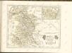

Hannover 58, uit: [W. Liebenow's Special-Karte von Mittel-Europa]
1 : 300000 titelvariant: W. Liebenow's Mittel-Europa; Annotatie: Titel boven de bladen: W. Liebenow's Mittel-Europa Johannes Wilhelm Liebenow 1822-1897 Hannover : Hermann Oppermann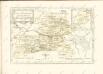

Hannover 58, uit: Special-Karte von Mittel-Europa / nach amtlichen Quellen bearbeitet von W. Liebenow
1 : 300000 titelvariant: W. Liebenow's Mittel-Europa; Annotatie: Titel boven de bladen: W. Liebenow's Mittel-Europa Johannes Wilhelm Liebenow 1822-1897 Frankfurt a. M. : Ludwig Ravenstein
Episcopatvs Hildesiensis descriptio novissima
1 : 320000 Mollova mapová sbírka Gigas, Johann Michael Schenk, Peter I
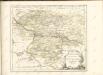
Episcopatvs Hildesiensis descriptio novissima
1 : 320000 Mollova mapová sbírka Gigas, Johann Michael Janssonius, Johannes I
Episcopatvs Hildesiensis descriptio novissima
1 : 440000 Mollova mapová sbírka Merian, Matthaeus Merian, Matthäus - dědici
Episcopatus Hildesiensis Descriptio Novissima [Karte], in: Gerardi Mercatoris et I. Hondii Newer Atlas, oder, Grosses Weltbuch, Bd. 1, S. 286.
1 Karte aus Atlas Mercator, Gerhard und Hondius, Jodocus Jansson, Jan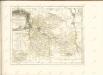
Geognostische Karte der Umgegend von Hannover
1 : 100000 Credner, Heinrich Hahn'sche Hofbuchhandlung
288. Braunschweig.
1 : 100000 Reichsamt fur Landesaufnahme
Composite: 262. Celle.
1 : 100000 Reichsamt fur Landesaufnahme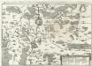
Eigentlicher grundt-riß, abbildung und Situation der Fürstl: Residentz und Haupt vestung Wolfenbüttel und der Stat Braunschweig, samt umbliegender gegent
1 : 130000 Mollova mapová sbírka Buno, Konrad Merian, Matthäus - dědici
Composite: 288. Braunschweig.
1 : 100000 Reichsamt fur Landesaufnahme
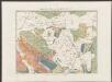
Episcopatus Hildesiensis nec non Vicinorum Statuum delineatio Geographica
1 : 290000 Mollova mapová sbírka Arenhold, Gerard J. Schneider, Ruprecht Adam Homann, Johann Baptista - dědici
Episcopatus Hildesiensis nec non vicinorum statuum delineatio geographica
1 : 287000 Hildesheim (Německo) Arenhold, Gerhard Justus Haered. Ioh. Baptist. Homanni