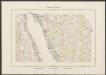
Maps of Hörstel

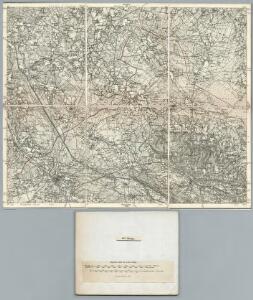
282. Rheine.
1 : 100000 Reichsamt fur Landesaufnahme
Composite: 282. Rheine.
1 : 100000 Reichsamt fur Landesaufnahme
Germany 1:25,000, Mettingen
Germany 1:25,000 , Series GSGS 4414. Great Britain. War Office. [London] : War Office
Germany 1:25,000, Hopsten
Germany 1:25,000 , Series GSGS 4414. Great Britain. War Office. [London] : War Office
Meßtischblatt 1942 : Mettingen, 1897
1 : 250000 Mettingen. - Aufn. 1895. - 1:25000. - [Berlin]: Reichsamt für Landesaufnahme, 1897. - 1 Kt.
Meßtischblatt 1941 : Hopsten, 1897
1 : 250000 Hopsten. - Aufn. 1895. - 1:25000. - [Berlin]: Reichsamt für Landesaufnahme, 1897. - 1 Kt.
Meßtischblatt 3610 : Salzbergen, 1944
1 : 250000 Salzbergen. - Aufn. 1895, hrsg. 1897, bericht. 1939. - 1:25000. - [Berlin]: Reichsamt für Landesaufnahme, 1944. - 1 Kt.
Germany 1:25,000, Salzbergen
Germany 1:25,000 , Series GSGS 4414. Great Britain. War Office. [London] : War Office
Meßtischblatt 1873 : Freren, 1897
1 : 250000 Freren. - Aufn. 1895. - 1:25000. - [Berlin]: Reichsamt für Landesaufnahme, 1897. - 1 Kt.
Meßtischblatt 1874 : Voltlage, 1897
1 : 250000 Voltlage. - Aufn. 1895. - 1:25000. - [Berlin]: Reichsamt für Landesaufnahme, 1897. - 1 Kt.
Meßtischblatt 1872 : Plantlünne, 1897
1 : 250000 Plantlünne. - Aufn. 1895. - 1:25000. - [Berlin]: Reichsamt für Landesaufnahme, 1897. - 1 Kt.
Germany 1:25,000, Bevergen
Germany 1:25,000 , Series GSGS 4414. Great Britain. War Office. [London] : War Office
Meßtischblatt 3712 : Tecklenburg, 1950
1 : 250000 Tecklenburg. - Aufn. 1895, hrsg. 1897, bericht. 1940. - 1:25000. - [Berlin]: Reichsamt für Landesaufnahme, 1950. - 1 Kt.
Meßtischblatt 2009 : Tecklenburg, 1897
1 : 250000 Tecklenburg. - Aufn. 1895. - 1:25000. - [Berlin]: Reichsamt für Landesaufnahme, 1897. - 1 Kt.
Meßtischblatt 3711 : Bevergern, 1947
1 : 250000 Bevergern. - Hrsg. 1897, bericht. 1940, letzte Nachtr. 1946. - 1:25000. - [Berlin]: Reichsamt für Landesaufnahme, 1947. - 1 Kt.
Meßtischblatt 2008 : Bevergern, 1897
1 : 250000 Bevergern. - Aufn. 1895. - 1:25000. - [Berlin]: Reichsamt für Landesaufnahme, 1897. - 1 Kt.
Meßtischblatt 3710 : Rheine, 1949
1 : 250000 Rheine. - Aufn. 1895, hrsg. 1897, bericht. 1940, letzte Nachtr. 1948. - 1:25000. - [Berlin]: Reichsamt für Landesaufnahme, 1949. - 1 Kt.
84. Osnabrück, uit: Topographische Uebersichtskarte des Deutschen Reiches / herausgegeben v. d. Kartogr. Abt. d. Königl. Preuß. Landesaufnahme
1 : 200000 titelvariant: Topogr. Übersichtskarte des Deutschen Reiches; Annotatie: Titel boven bladen ook: Topogr. Übersichtskarte des Deutschen Reiches; Annotatie geografische gegevens: Op elk blad twee maatstokken: 10 Kilometer = 5,5 cm; 1 geogr. Meile = 3,6 cm; Legenda onder op elk blad Königlich Preußische Landesaufnahme. Kartographische Abtheilung [S.l : Königlich Preußische Landesaufnahme, Kartographische Abtheilung]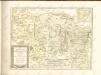
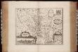
Osnabrugensis episcopatus / auctore Ioanne Gigante ; [Willem Jansz. Blaeu]
1 : 250000 Annotatie: Bij deze 2e staat zijn de lengtegraden in de kaartrand veranderd van O 28°40'-30°20' in O 25°20'-26°50'; Origineel is Blad 77 in atlas factice; Oorspr. uitg.: Atlantis appendix, sive pars altera ... - Amsterdami : apud Guiljelmum Blaeuw, 1630 Gigas, Joannes (1580-1650); Blaeu, Willem Jansz. Amstelodami : Guiljelm. Blaeu excudit [i.e. Joan Blaeu]
Osnabrvgensis Episcopatvs
1 : 470000 Mollova mapová sbírka Gigas, Johann Michael Schenk, Peter I
Osnabrvgensis Episcopatvs
1 : 470000 Mollova mapová sbírka Gigas, Johann Michael
OSNABRVGENSIS | EPISCOPATVS
Auctore Ioanne Gigante. Amstelodami, | Guiljelm. Blaeuw | Excudit
Osnabrugensis Episcopatus. [Karte] Districtus Reckenbergensis. [Nebenkarte], in: Novus atlas absolutissimus, Bd. 2, S. 115.
1 Karte aus Atlas Janssonius Offizin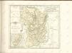
Osnabrugensis Episcopatus. [Karte] Districtus Reckenbergensis. [Nebenkarte], in: Le théâtre du monde, ou, Nouvel atlas contenant les chartes et descriptions de tous les païs de la terre, Bd. 1, S. 166.
1 Karte aus Atlas Blaeu, Willem Janszoon und Blaeu, Joan Blaeu, Willem Janszoon
Osnabrugensis Episcopatus. [Karte] Districtus Reckenbergensis. [Nebenkarte], in: Novus Atlas, das ist, Weltbeschreibung, Bd. 1, S. 135.
1 Karte aus Atlas Blaeu, Joan Blaeu, Willem Janszoon
Osnabrugensis Episcopatus. [Karte] Districtus Reckenbergensis. [Nebenkarte], in: Gerardi Mercatoris et I. Hondii Newer Atlas, oder, Grosses Weltbuch, Bd. 1, S. 170.
1 Karte aus Atlas Mercator, Gerhard und Hondius, Jodocus Jansson, Jan
Osnabrvgensis episcopatvs
1 : 236000 Osnabrück (Německo) Gigas, Johann Michael Blaeu, Willem Janszoon Guilielm Blaeuw