Maps of Samtgemeinde Neuenhaus

256. Lingen.
1 : 100000 Reichsamt fur Landesaufnahme
Composite: 256. Lingen.
1 : 100000 Reichsamt fur Landesaufnahme
23 Nw. Schoonebeek, uit: Topographische en militaire kaart van het Koningrijk der Nederlanden / vervaardigd door de officieren van den Generale Staf ; en gegraveerd op het Topographisch Bureau, van het Ministerie van Oorlog
1 : 50000 titelvariant: TMK; Annotatie: Met bladwijzer op schaal 1:600.000. - 1915; Met Verklaring van de topographische en militaire kaart van het Koninkrijk der Nederlanden. - 1910; Bd. 1: titelblad, bladwijzer, verklaring, bladen 1 t/m 32; Bd. 2: bladen 33 t/m 62 Generale Staf, Nederland; Ministerie van Oorlog. Topographisch Bureau ['s-Gravenhage : Ministerie van Oorlog]
Meßtischblatt 1800 : Lingen, 1898
1 : 250000 Lingen. - Aufn. 1896. - 1:25000. - [Berlin]: Reichsamt für Landesaufnahme, 1898. - 1 Kt.
Meßtischblatt 1799 : Wietmarschen, 1908
1 : 250000 Wietmarschen. - Aufn. 1896, hrsg. 1897, einz. Nachtr. 1908. - 1:25000. - [Berlin]: Reichsamt für Landesaufnahme, 1908. - 1 Kt.
Meßtischblatt 1798 : Veldhausen, 1916
1 : 250000 Veldhausen. - Aufn. 1896, hrsg. 1898, Auflagedr. 1916. - 1:25000. - [Berlin]: Reichsamt für Landesaufnahme, 1916. - 1 Kt.
Meßtischblatt 1728 : Meppen, 1925
1 : 250000 Meppen. - Aufn. 1896, einz. Nachtr. 1925. - 1:25000. - [Berlin]: Reichsamt für Landesaufnahme, 1925. - 1 Kt.
Meßtischblatt 1728 : Meppen, 1897
1 : 250000 Meppen. - Aufn. 1896, hrsg. 1897. - 1:25000. - [Berlin]: Reichsamt für Landesaufnahme, 1897. - 1 Kt.
Meßtischblatt 1727 : Hesepertwist, 1897
1 : 250000 Hesepertwist. - Aufn. 1896, hrsg. 1897. - 1:25000. - [Berlin]: Reichsamt für Landesaufnahme, 1897. - 1 Kt.
Meßtischblatt 1726 : Emlichheim, 1897
1 : 250000 Emlichheim. - Aufn. 1896, hrsg. 1897. - 1:25000. - [Berlin]: Reichsamt für Landesaufnahme, 1897. - 1 Kt.
LINGÆ OBSIDIO | Confecta ab Il.mi Principe | MAVRITIO NASSOVIO, etc. | Armis Ordd. Belgicæ Foederatæ Ao. 1605.
[Amsterdam : Joan Blaeu]
LINGA OBSESSA et EXPVGNATA | Per AMBROSIVM SPINOLAM VENAFRI Marchionem, | Capitaneum generalem Archiducum Austriæ, | ALBERTI et ISABELLÆ, Brabantiæ Ducum etc. An. 1605
[Amsterdam : Joan Blaeu]
LINGHEN : [fortification plan].
[Amsterdam : Joan Blaeu]
Meßtischblatt 1871 : Lohne, 1897
1 : 250000 Lohne. - Aufn. 1895. - 1:25000. - [Berlin]: Reichsamt für Landesaufnahme, 1897. - 1 Kt.
Meßtischblatt 1870 : Nordhorn, 1897
1 : 250000 Nordhorn. - Aufn. 1895. - 1:25000. - [Berlin]: Reichsamt für Landesaufnahme, 1897. - 1 Kt.
Meßtischblatt 1869 : Neuenhaus, 1897
1 : 250000 Neuenhaus. - Aufn. 1895. - 1:25000. - [Berlin]: Reichsamt für Landesaufnahme, 1897. - 1 Kt.
12me Koeverden, uit: Nouvelle carte de la Hollande, d'après Kraijenhoff et les meilleures cartes connues / Établissement Géographique de Bruxelles, fondé par Ph. Vander Maelen
1 : 117000 Annotatie: De bladen zijn genummerd 1-24. De bladen 2 t/m 24 hebben elk een afzonderlijke titel. Blad 5 bevat: Triangulations et positions. Blad 9 bevat: Plan d'Amsterdam; De kaartbladen 1, 5, 9 en 24 zijn niet ingekleurd; Van kaartblad 24 is een extra (ingekleurd) exempl. aanwezig; Annotatie geografische gegevens: 2 schaalstokken: 5 Echelle de 5 lieues de 20 au degré ... (= 23,2 cm) en 7380 Echelle de 5 lieues de 20 au degré ... (= 23,2 cm); Legenda; Met indexkaart: Carte d'assemblage Philippe Marie Guillaume Vander Maelen 1795-1869; Établissement Géographique de Bruxelles Bruxelles : Établissement Géographique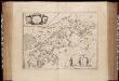
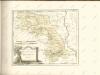
Comitatus Bentheim, et Steinfurt / auctore Ioanne Westenberg ; [Willem Jansz. Blaeu]
1 : 230000 Annotatie: Het eerst verschenen in: Ander Theil Novi Atlantis ... - Amsterdami : apud Guiljelmum et Johannem Blaeu, 1635; Origineel is Blad 78 in atlas factice; Annotatie geografische gegevens: Oost boven Westenberg, Johannes; Blaeu, Willem Jansz. [Amsterdam : Guljelm. Blaeu excudebat]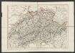
Comitatus Bentheimensis Nova Descriptio [Karte], in: Gerardi Mercatoris et I. Hondii Newer Atlas, oder, Grosses Weltbuch, Bd. 1, S. 173.
1 Karte aus Atlas Mercator, Gerhard und Hondius, Jodocus Jansson, Jan
Comitatus Bentheim, et Steinfurt. [Karte], in: Novus atlas absolutissimus, Bd. 2, S. 121.
1 Karte aus Atlas Janssonius Offizin
Comitatus Bentheim, et Steinfurt. [Karte], in: Novus Atlas, das ist, Weltbeschreibung, Bd. 1, S. 132.
1 Karte aus Atlas Blaeu, Joan Blaeu, Willem Janszoon
Comitatus Bentheim, et Steinfurt. [Karte], in: Le théâtre du monde, ou, Nouvel atlas contenant les chartes et descriptions de tous les païs de la terre, Bd. 1, S. 163.
1 Karte aus Atlas Blaeu, Willem Janszoon und Blaeu, Joan Blaeu, Willem Janszoon
Comitatus Bentheim, et Steinfurt. [Karte], in: Theatrum orbis terrarum, sive, Atlas novus, Bd. 1, S. 212.
1 Karte aus Atlas Blaeu, Joan Blaeu, Willem Janszoon
Comitatvs Bentheim, et Steinfvrt
1 : 160000 Mollova mapová sbírka Westenberg, Joann Schenk, Peter I
Comitatus Bentheimensis
1 : 160000 Mollova mapová sbírka Westenberg, Joann Schenk, Peter I
Transisalania Provincia; Vulgo Over-yssel
1 : 190000 Mollova mapová sbírka Have, Nicholas ten Schenk, Peter II
70. Laar, uit: Topographische Uebersichtskarte des Deutschen Reiches / herausgegeben v. d. Kartogr. Abt. d. Königl. Preuß. Landesaufnahme
1 : 200000 titelvariant: Topogr. Übersichtskarte des Deutschen Reiches; Annotatie: Titel boven bladen ook: Topogr. Übersichtskarte des Deutschen Reiches; Annotatie geografische gegevens: Op elk blad twee maatstokken: 10 Kilometer = 5,5 cm; 1 geogr. Meile = 3,6 cm; Legenda onder op elk blad Königlich Preußische Landesaufnahme. Kartographische Abtheilung [S.l : Königlich Preußische Landesaufnahme, Kartographische Abtheilung]