Maps of Emstek

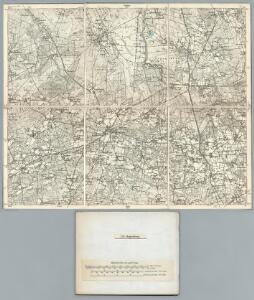
233. Cloppenburg.
1 : 100000 Reichsamt fur Landesaufnahme
Composite: 233. Cloppenburg.
1 : 100000 Reichsamt fur Landesaufnahme
Messtischblatt 1592 : Visbek, 1934 Visbek
1 : 250000 Visbek. - Hrsg. 1900, einz. Nachtr. 1925. - 1:25000. - [Berlin]: Reichsamt für Landesaufnahme, 1934. - 1 Kt.
Messtischblatt 1590 : Molbergen, 1925 Molbergen
1 : 250000 Molbergen. - Aufn. 1898, einz. Nachtr. 1925. - 1:25000. - [Berlin]: Reichsamt für Landesaufnahme, 1925. - 1 Kt.
Messtischblatt 1591 : Cloppenburg, 1900 Cloppenburg
1 : 250000 Cloppenburg. - Aufn. 1898. - 1:25000. - [Berlin]: Reichsamt für Landesaufnahme, 1900. - 1 Kt.
Meßtischblatt 1519 : Markhausen, 1900
1 : 250000 Markhausen. - Aufn. 1898. - 1:25000. - [Berlin]: Reichsamt für Landesaufnahme, 1900. - 1 Kt.
Meßtischblatt 1520 : Garrel, 1900
1 : 250000 Garrel. - Aufn. 1898. - 1:25000. - [Berlin]: Reichsamt für Landesaufnahme, 1900. - 1 Kt.
Meßtischblatt 1521 : Grossenkneten, 1925
1 : 250000 Grossenkneten. - Aufn. 1898, einz. Nachtr. 1925. - 1:25000. - [Berlin]: Reichsamt für Landesaufnahme, 1925. - 1 Kt.
Meßtischblatt 1662 : Vechta, 1900
1 : 250000 Vechta. - Aufn. 1898, hrsg. 1900. - 1:25000. - [Berlin]: Reichsamt für Landesaufnahme, 1900. - 1 Kt.
Meßtischblatt 1661 : Vestrup, 1900
1 : 250000 Vestrup. - Aufn. 1898, hrsg. 1900. - 1:25000. - [Berlin]: Reichsamt für Landesaufnahme, 1900. - 1 Kt.
Meßtischblatt 1660 : Essen, 1900
1 : 250000 Essen. - Aufn. 1898, hrsg. 1900. - 1:25000. - [Berlin]: Reichsamt für Landesaufnahme, 1900. - 1 Kt.
71. Cloppenburg, uit: Topographische Uebersichtskarte des Deutschen Reiches / herausgegeben v. d. Kartogr. Abt. d. Königl. Preuß. Landesaufnahme
1 : 200000 titelvariant: Topogr. Übersichtskarte des Deutschen Reiches; Annotatie: Titel boven bladen ook: Topogr. Übersichtskarte des Deutschen Reiches; Annotatie geografische gegevens: Op elk blad twee maatstokken: 10 Kilometer = 5,5 cm; 1 geogr. Meile = 3,6 cm; Legenda onder op elk blad Königlich Preußische Landesaufnahme. Kartographische Abtheilung [S.l : Königlich Preußische Landesaufnahme, Kartographische Abtheilung]
Bremen 44, uit: Special-Karte von Mittel-Europa / nach amtlichen Quellen bearbeitet von W. Liebenow
1 : 300000 titelvariant: W. Liebenow's Mittel-Europa; Annotatie: Titel boven de bladen: W. Liebenow's Mittel-Europa Johannes Wilhelm Liebenow 1822-1897 Frankfurt a. M. : Ludwig Ravenstein
Bremen 44, uit: [W. Liebenow's Special-Karte von Mittel-Europa]
1 : 300000 titelvariant: W. Liebenow's Mittel-Europa; Annotatie: Titel boven de bladen: W. Liebenow's Mittel-Europa Johannes Wilhelm Liebenow 1822-1897 Hannover : Hermann Oppermann
Le Theatre de Bellone :
Mollova mapová sbírka Schenk, Pieter Braakman, Adriaan
[8], uit: Hydro-Oro und Chorographische General Karte des Koenigreichs der Niederlande und der angrenzenden Länder bis Paris : mit der Angabe der Kunst und Heer-Strassen und der Entfernung der Poststationen / ... zusammengetragen und reducirt von ... Wilhelm Müller
1 : 400000 titelvariant: Generalkarte des Koenigreichs Hannover; Annotatie: 1e supplement bij: Generalkarte des Koenigreichs Hannover (1818) Müller, Wilhelm (fl. 1818) [Hannover : Wilhelm Müller]

Episcopatvs Monasteriensis Pars Septentrionalis
1 : 290000 Mollova mapová sbírka Gigas, Johann Michael
Episcopatvs Monasteriensis Pars Septentrionalis
1 : 290000 Mollova mapová sbírka Gigas, Johann Michael
Oldenburg Comit. [Karte], in: Theatrum orbis terrarum, S. 213.
1 Karte aus Atlas Ortelius, Abraham Vrients, Jan Baptista

Oldenbvrg Comit.
1 : 250000 Mollova mapová sbírka Michaelis, Laurentius Plantin, Christoph
Nobilis Saxoniae Fl. Visvrgis cum Terris adjacentib. Ab Inclyta Brema ad Ostium Maris
1 : 130000 Mollova mapová sbírka Merian, Matthaeus Merian, Matthäus - dědici
Oldenburg Comitatus [Karte], in: Le théâtre du monde, ou, Nouvel atlas contenant les chartes et descriptions de tous les païs de la terre, Bd. 1, S. 154.
1 Karte aus Atlas Blaeu, Willem Janszoon und Blaeu, Joan Blaeu, Willem Janszoon
Comitatvvm Oldenbvrg et Delmenhorst
1 : 170000 Mollova mapová sbírka Hunrichs, Johann Wilhelm Anton Homann, Johann Baptista - dědici
Comitatvvm Oldenbvrg et Delmenhorst
1 : 166000 Oldenburg (Německo) Hunrichs, Johann Wilhelm Anton Münnich, Anton Günther von Homannianorum heredum
205. Oldenburg. (Germany)
1 : 100000 Reichsamt fur Landesaufnahme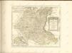

Oldenburg Grossherzogthum.
1 : 490000 Gotthard, A.